
NCERT Solutions Class 7 Social Science Chapter 1: Geographical Diversity of India
Answers to every question in Chapter 1, Geographical Diversity of India, of Exploring Society: India and Beyond Grade 7 Part 1 (Reprint 2026-27): the Big Questions, every Let’s Explore and Let’s Remember question, the puzzle in Don’t Miss Out, and all nine questions and activities. Page numbers follow the book (pages 1–25). Answers that depend on where you live are given as samples to adapt. Short notes: Chapter 1 notes.
The Big Questions (page 1)
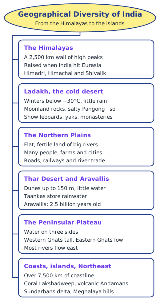
1. What are some key geographical features of India? The Himalayas across the north, with the cold desert of Ladakh; the fertile Gangetic (Northern) Plains; the Thar Desert in the west, with the ancient Aravalli Hills to its east; the Peninsular Plateau between the Western and Eastern Ghats; the long coastline with estuaries on the west, and deltas and lagoons on the east; the Lakshadweep and Andaman and Nicobar Islands; the Sundarbans delta; and the hills of the Northeast.
2. How does India’s geographical diversity affect our lives? It shapes almost everything: where people live (crowded plains, few people in the high mountains), the work they do (farming on the plains, fishing on the coasts, mining on the plateau, herding yaks in Ladakh), their houses (kath-kuni homes in the hills), food and clothing, how they find water (taankas in the Thar), how they travel, and their festivals and beliefs, such as sacred rivers and mountains.
Let’s Explore (page 2)
What can you observe on the physical map at the end of the book? High mountains along the north, wide plains below them, a desert in the west, a raised plateau in the south edged by hills, coastal plains along both seas, and two groups of islands. Mountains, plains and plateaus are all there. The colours show height above sea level: as the legend explains, greens mark low land, yellows and browns mark higher land, and the darkest shades mark the highest mountains; blue shows water.
Let’s Explore (page 3)
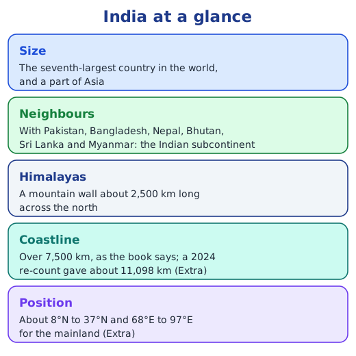
Where does India lie in latitude and longitude? Roughly between 8°N and 37°N, and between 68°E and 97°E (Extra: the mainland runs from about 8°4′N to 37°6′N and from 68°7′E to 97°25′E). The Tropic of Cancer passes through the middle of the country.
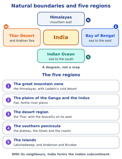
Identify the features on the physical map. The Himalayas along the north; the Thar Desert and the Arabian Sea on the west; the Indian Ocean to the south; and the Bay of Bengal on the east.
The altitude of the Himalayas from the legend. The foothills next to the plains are only a few hundred metres high, the middle ranges are a few thousand metres, and the highest peaks rise above 8,000 m, shown in the darkest colour.
Let’s Remember (page 4)
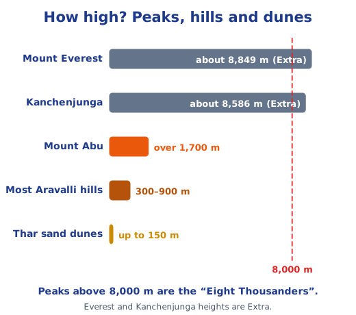
Can you name the highest mountain in the world? Mount Everest, on the border of Nepal and China, part of the Himadri. Extra: it is about 8,849 m high; Kanchenjunga, about 8,586 m, is the highest peak in India.
Let’s Explore (page 6)
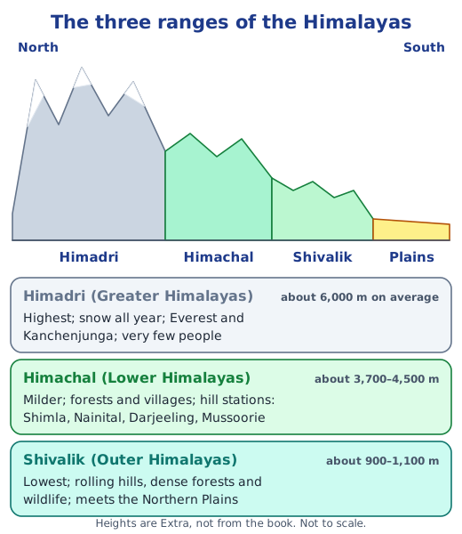
Which states lie in the different parts of the Himalayas? From west to east the Himalayas cross the union territories of Ladakh and Jammu and Kashmir, and the states of Himachal Pradesh, Uttarakhand, Sikkim, the northern hills of West Bengal, and Arunachal Pradesh. The hill stations in the book help to place the Himachal range: Shimla in Himachal Pradesh, Nainital and Mussoorie in Uttarakhand, and Darjeeling in West Bengal. The Shivalik foothills run along the edge of the plains in states such as Himachal Pradesh and Uttarakhand.
Don’t Miss Out (page 11)
The Brahmaputra grows bigger in summer instead of drying up. Why? In summer the snow and glaciers of the Himalayas melt and pour water into it, and soon after, the monsoon rains add even more. So its flow rises when you might expect a river to shrink.
Let’s Explore (page 11)
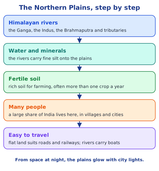
Why are the lights concentrated in the plains in the satellite image? Far more people live on the plains than in the mountains or the desert. Flat, fertile land supports farming, and many villages, towns and big cities have grown there, linked by roads and railways; their lights glow at night.
Let’s Explore (page 12)
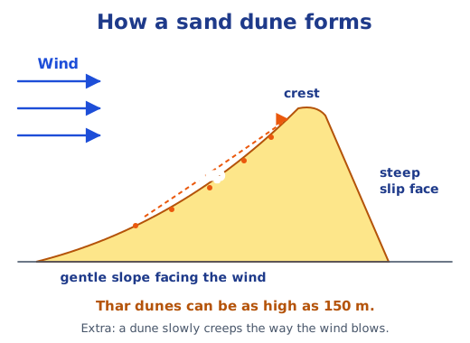
What is the shape of a sand dune, and why does it keep that shape though it is made of sand? A dune has a long, gentle slope on the side facing the wind and a short, steep slope on the sheltered side, often curving like a crescent. The wind keeps pushing sand up the gentle side; at the top, the sand slides down the steep side until it settles at a slope where it can rest. Because the same wind keeps doing the same work, the dune keeps a similar hill-like shape, even as it slowly moves.
Let’s Explore (pages 14–15)
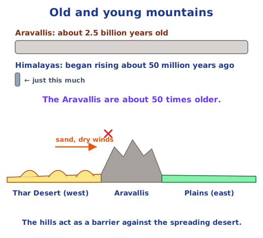
Trace a path east from the Thar Desert. Do you see the Aravalli Hills? Yes: a long belt of hills runs from near Delhi in the northeast to Gujarat in the southwest, along the eastern edge of the desert.
Which states does the range span? Delhi, Haryana, Rajasthan and Gujarat.
Let’s Explore (page 16)
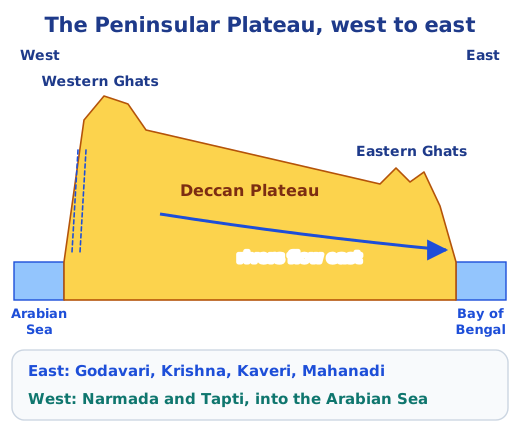
Notice the direction of the flow of the rivers. Most rivers of the peninsula, the Mahanadi, Godavari, Krishna and Kaveri, flow from west to east into the Bay of Bengal, because the plateau tilts towards the east. The Narmada and the Tapti are the exceptions: they flow west into the Arabian Sea.
Let’s Explore (page 17)
Locate the states with many tribal communities on the physical map. Jharkhand, Odisha, Chhattisgarh, Madhya Pradesh, Telangana, Maharashtra and Gujarat lie mostly on the forested plateau and hills of central and peninsular India; West Bengal’s western districts touch the same plateau; and Assam lies in the Brahmaputra valley of the Northeast. So most of these communities live in hilly, forested parts of the plateau, close to Nature.
Let’s Explore (page 19)
Five rivers that flow into the Bay of Bengal. Any five of the Ganga, Brahmaputra, Mahanadi, Godavari, Krishna and Kaveri.
India’s coastal states. On the west coast: Gujarat, Maharashtra, Goa, Karnataka and Kerala. On the east coast: Tamil Nadu, Andhra Pradesh, Odisha and West Bengal. Extra: the union territories of Puducherry, Daman and Diu, Lakshadweep, and the Andaman and Nicobar Islands also have coasts.
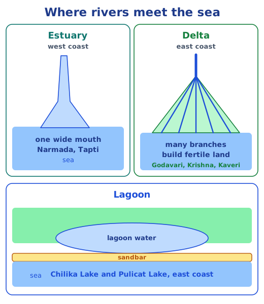
The difference between the western and eastern coastal plains. The western plain is narrow, because the Western Ghats come close to the sea; its short, swift rivers form estuaries, creeks and coves. The eastern plain is wider; its long rivers form large deltas, and it has lagoons such as Chilika and Pulicat.
What is it called when rivers split into many streams near the coast? The branches are called distributaries, and the land they build is a delta.
Questions and activities (pages 24–25)
1. Two important geographical features of India, and why. Sample answer: the Himalayas, because they guard the north, shape our climate and, as the Water Tower of Asia, feed the Ganga, Indus and Brahmaputra with snowmelt; and the Northern Plains, because their fertile soil grows much of India’s food and they are home to a large share of its people. (The Peninsular Plateau, with its minerals and forests, or the long coastline, with its ports and fishing, are also good choices.)
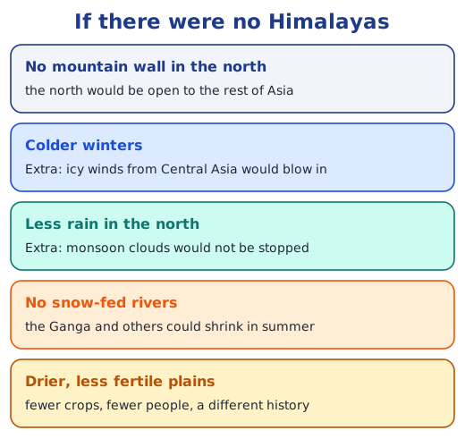
2. What might India look like without the Himalayas? Sample note: There would be no great wall in the north. Snow-fed rivers such as the Ganga would carry much less water in summer, so the plains would be drier and less fertile, with fewer farms and people. Extra: icy winds from Central Asia would sweep in, making winters colder, and the monsoon clouds would not be stopped, so the north would get less rain. India’s climate, culture and history would all be very different.
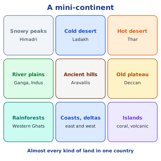
3. Why is India called a ‘mini-continent’? Because within one country it has nearly every kind of landscape you would expect across a whole continent: snowy peaks, a cold desert and a hot desert, great river plains, ancient hills, an old plateau, rainforests, long coasts with estuaries and deltas, and coral and volcanic islands. With them come many climates, plants, animals and ways of life. It is also large, the seventh-largest country, and gives its name to the subcontinent.
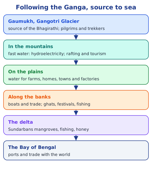
4. Follow a big river from source to sea: how do people use it? Sample for the Ganga: at Gaumukh, the source of the Bhagirathi, pilgrims and trekkers visit the glacier; in the mountains the fast water turns turbines for hydroelectricity and draws rafters and tourists; on the plains it waters fields and supplies homes, towns and factories, and boats carry goods and people; along its banks there are ghats, fairs and festivals, and people fish; in the delta, the Sundarbans give fish and honey; and at the Bay of Bengal, ports trade with the world.
5. Why is southern India called a peninsular plateau? It is a plateau because it is raised land with a fairly flat top, edged by the steep slopes of the Western and Eastern Ghats. It is a peninsula because water surrounds it on three sides: the Arabian Sea on the west, the Bay of Bengal on the east and the Indian Ocean on the south.
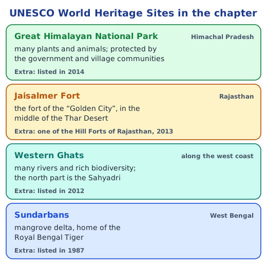
6. A UNESCO Heritage Site you found interesting. Sample paragraph about the Sundarbans: The Sundarbans interested me most because it is a forest that grows in water. At the mouth of the Ganga and the Brahmaputra, mangrove trees stand on stilt-like roots among countless channels where river and sea meet. About half of it is in India and half in Bangladesh, and it is home to the Royal Bengal Tiger. The other sites in the chapter are the Great Himalayan National Park, Jaisalmer Fort and the Western Ghats.
7. Describe where you are using a physical feature. Find your town on the political map, then look at the same spot on the physical map and note the landform and the nearest river or hills. Samples: “I live in Patna, on the Gangetic Plains, on the banks of the Ganga”; “Pune is on the Deccan Plateau, just east of the Western Ghats”; “Jodhpur is in the Thar Desert”; “Kochi is on the west coast, between the Western Ghats and the Arabian Sea”; “Shimla is in the Himachal range of the Himalayas”.
8. Food preservation across India (class project). Methods suit the local weather and produce. Samples: in the dry, sunny Thar, beans and berries such as ker and sangri are sun-dried; across India, vegetables, mangoes and lemons are pickled in salt, oil and spices; on the coasts, fish is salted and sun-dried; in the cold mountains, apricots and vegetables are dried for winter; in parts of the Northeast, meat is smoked over the kitchen fire and bamboo shoots are fermented; and many homes make papads and vadis, or store grain in large earthen bins. Make a class chart with the method, the region and why it suits that place.
9. How has geography helped unite India? The Himalayas and the seas give India shared natural borders. Rivers such as the Ganga link many regions and have carried trade and travel for thousands of years. Regions depend on one another: grain from the plains, fish and salt from the coasts, minerals from the plateau and water from the Himalayan rivers. People travel across the land on pilgrimages to sacred rivers and mountains, and most regions share the rhythm of the monsoon. Different landscapes, joined in these ways, have made a shared culture.
Practice
-
Which of these lakes has salty water?
Show answer
Answer: (b) Pangong Tso
-
The Bhagirathi, a main stream of the Ganga, begins at:
Show answer
Answer: (a) Gaumukh
-
Which UNESCO World Heritage Site is shared by India and Bangladesh?
Show answer
Answer: (c) The Sundarbans
-
Name two ways in which people of the Thar Desert save water.
Show answer
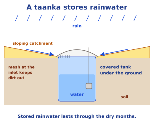
Answer: They scrub utensils clean with sand and use only a little water to rinse them, then reuse that water for plants; and they collect rainwater in covered tanks such as taankas or kunds, often for drinking.
-
How is the Sundarbans different from the delta of the Godavari?
Show answer
Answer: Both are deltas where rivers split and drop their silt, but the Sundarbans, at the mouth of the Ganga and the Brahmaputra, is a huge mangrove forest crossed by tidal rivers and shared with Bangladesh, while the Godavari delta in Andhra Pradesh is mostly farmland.
Stuck on a question?
Take a photo and Lagnever AI explains it step by step. Try it for 7 days for ₹2.
Get it on Google Play Open in browser
For parents: after the trial, the plan renews monthly by UPI or card autopay. You can cancel anytime in the app.