
Class 7 Social Science Chapter 1: Geographical Diversity of India Notes
This chapter in five lines
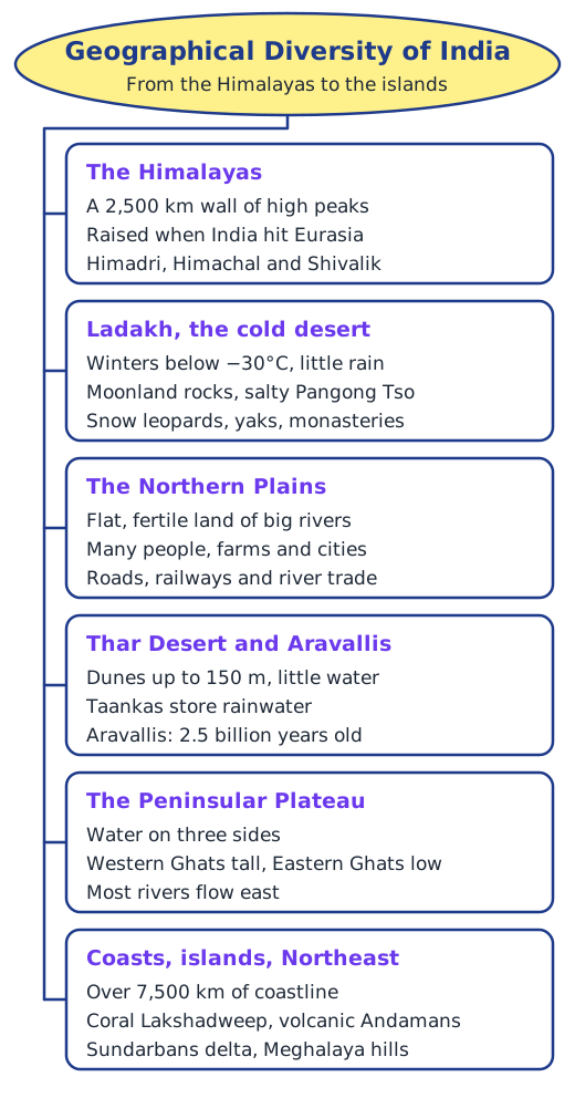
Geographical Diversity of India is a bird’s-eye journey across India’s landforms: the Himalayas in the north, the cold desert of Ladakh, the fertile Gangetic Plains, the Thar Desert and the ancient Aravallis, the Peninsular Plateau between the Western and Eastern Ghats, a coastline of over 7,500 km, two island groups, the Sundarbans delta and the hills of the Northeast. It shows how each region shapes the lives of the people who live there.
What is this chapter about?
In 1984 Rakesh Sharma, the first Indian in space, was asked how India looked from up there. He answered with the title of a famous poem, Saare jahan se achchha, meaning better than all the world. This chapter takes a similar view from above. It ‘flies’ over India, the world’s seventh-largest country, from the Himalayas to the islands, and stops for close-ups of a few places along the way. Keep the physical map at the end of the textbook open as you read: its colours show how high the land is.
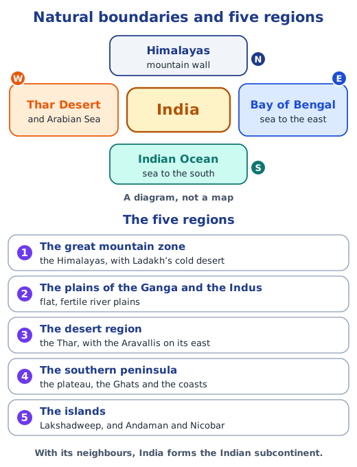
With its neighbours, India forms the Indian subcontinent. Natural features ring it: the Himalayas in the north, the Thar Desert and the Arabian Sea in the west, the Indian Ocean to the south and the Bay of Bengal to the east. They have shaped India’s climate, culture and history.
The Himalayas
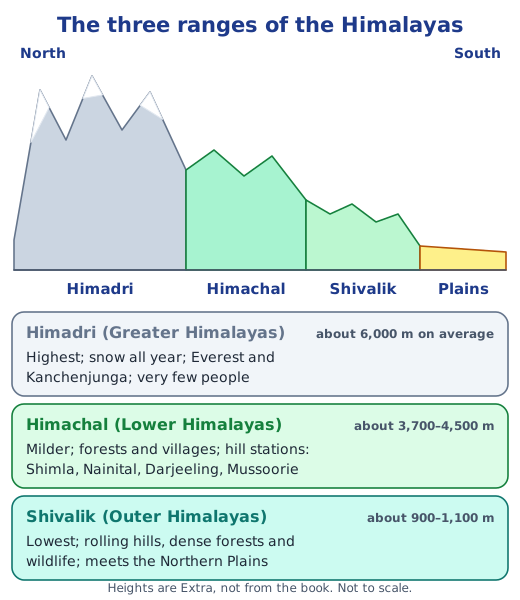
The Himalayas stretch about 2,500 km like a giant wall, with many peaks above 8,000 m. They formed when India, once part of a landmass called Gondwana, drifted north and crashed into Eurasia about 50 million years ago; the land between them crumpled upwards like a pushed carpet. India still pushes about 5 cm a year, so the mountains grow about 5 mm a year. They have three ranges: the snowy Himadri, the milder Himachal with its hill stations, and the low, forested Shivaliks. Melting snow feeds the Ganga, Indus and Brahmaputra, which is why the Himalayas are called the Water Tower of Asia. Read more in the Himalayas.
Ladakh, a cold desert
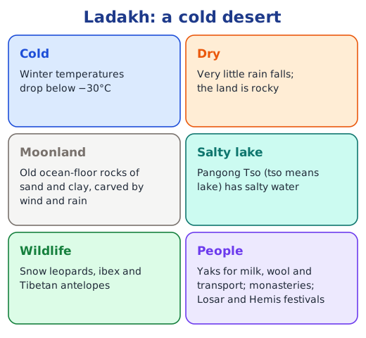
Deserts are not always hot. Ladakh gets very little rain and its winters drop below −30°C. Its rocks, once part of an ocean floor, were folded up with the Himalayas and then carved by wind and rain into a moon-like landscape. Pangong Tso is a salty lake. Snow leopards, ibex and yaks live here, and the region is known for its monasteries and festivals such as Losar and Hemis.
The Gangetic Plains
South of the mountains lie the wide, flat Gangetic or Northern Plains. Himalayan rivers bring water and minerals that make the soil very fertile, so farming thrives and a large share of India’s people live here. Flat land also makes roads and railways easy to build, and the rivers have carried boats and trade for thousands of years. Seen from space at night, the plains glow with lights.
The Thar Desert and the Aravallis
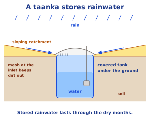
To the west lies the Thar, a dry land of sand dunes as high as 150 m, hot days and cold nights. People here save every drop: they scrub utensils with sand and store rainwater in underground tanks called taankas. East of the desert run the Aravallis, some 2.5 billion years old and among the oldest mountains on Earth. They act as a barrier that keeps the desert from moving east, and they are rich in minerals; Indians were extracting zinc at Zawar over 800 years ago.
The Peninsular Plateau
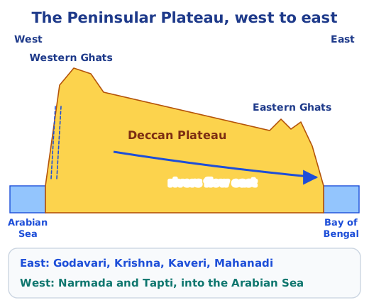
The triangular south of India is a very old plateau with water on three sides, so it is a peninsula. The tall Western Ghats rise like a wall near the west coast, while the Eastern Ghats are low and split into separate hills. The plateau tilts east, so the Godavari, Krishna, Kaveri and Mahanadi flow to the Bay of Bengal, while the Narmada and Tapti flow west. It is rich in minerals, forests and waterfalls, and is home to tribal communities such as the Santhal, Gond, Bhil and Baiga. See physical features of India.
Coasts and islands
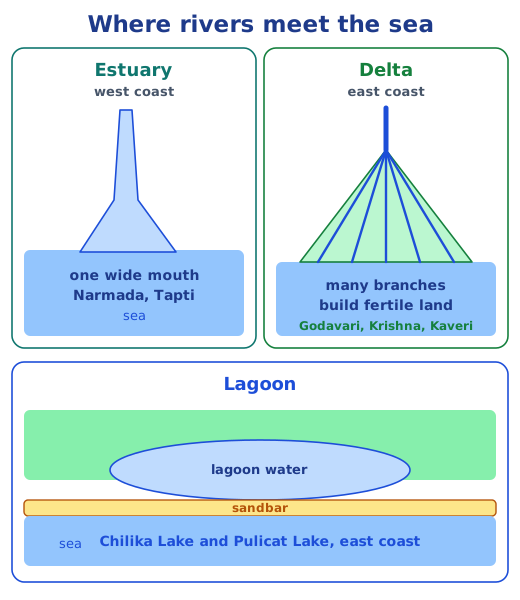
India’s coastline is over 7,500 km long. The narrow west coast, from Gujarat to Kerala, has short, swift rivers that form estuaries, and busy ports such as Mumbai. The wider east coast has big rivers that build fertile deltas, and lagoons such as Chilika and Pulicat. Out at sea are two island groups: the 36 coral islands of Lakshadweep in the Arabian Sea and, in the Bay of Bengal, the more than 500 volcanic islands of the Andaman and Nicobar Islands, with Barren Island, India’s only active volcano. Read coastlines and islands.
The Sundarbans and the Northeast
The journey ends in the east. The Sundarbans, in the delta of the Ganga and the Brahmaputra, is a mangrove forest shared with Bangladesh and home to the Royal Bengal Tiger. Further north, the Garo, Khasi and Jaintia hills of Meghalaya receive some of the heaviest rain in the world; local tribes weave tree roots into living bridges, and Mawlynnong is called the cleanest village in Asia.
Answers to the Big Questions, every Let’s Explore box and all nine questions and activities are in the NCERT solutions for Chapter 1.
Key terms
| Term | Meaning |
|---|---|
| Indian subcontinent | The region formed by India together with Nepal, Bhutan, Bangladesh, Myanmar, Sri Lanka and Pakistan. It is called a subcontinent because it is a large part of the continent of Asia. |
| Himalayas | The great mountain range across the north of India, about 2,500 km long. The name means ‘abode of snow’, from the Sanskrit hima (snow) and alaya (dwelling). |
| Himadri, Himachal and Shivalik | The three main ranges of the Himalayas: the Himadri or Greater Himalayas (highest), the Himachal or Lower Himalayas, and the Shivalik or Outer Himalayas (lowest). |
| Glacier | A huge, slowly moving mass of ice. The Bhagirathi, a main stream of the Ganga, begins at Gaumukh, the edge of the Gangotri Glacier. |
| Cold desert | A dry region with very little rain where it is cold for much of the year. Ladakh is India’s cold desert; its winters fall below −30°C. |
| Plateau | A landform that rises above the land around it and has a more or less flat top, often with steep sides. |
| Peninsula | Land with water on three sides. India’s southern plateau has the Arabian Sea, the Indian Ocean and the Bay of Bengal around it. |
| Western and Eastern Ghats | The two mountain ranges along the edges of the Peninsular Plateau. The Western Ghats are taller and unbroken; the Eastern Ghats are low and split into separate hills. |
| Estuary | The wide mouth where a river meets the sea in a single channel. The Narmada and Tapti estuaries on the west coast are the largest. |
| Delta | A fan- or triangle-shaped landform built where a river drops its sediment at its mouth and splits into many streams, as the Mahanadi, Godavari, Krishna and Kaveri do. |
| Lagoon | A body of water cut off from the larger sea by a natural barrier such as a sandbar, like Chilika Lake and Pulicat Lake. |
| Archipelago | A group of islands. Lakshadweep (36 coral islands) and the Andaman and Nicobar Islands (more than 500 volcanic islands) are India’s two archipelagos. |
Topics in this chapter
Practice
-
Which is the highest of the three Himalayan ranges?
Show answer
Answer: (c) Himadri
-
Why is Ladakh called a cold desert?
Show answer
Answer: (b) It gets very little rain and is very cold
-
Most rivers of the Peninsular Plateau flow into the Bay of Bengal because:
Show answer
Answer: (a) the plateau tilts to the east
-
Which of these is a lagoon?
Show answer
Answer: (b) Chilika Lake
-
Barren Island, India’s only active volcano, is part of:
Show answer
Answer: (c) the Andaman and Nicobar Islands
-
Which hills stop the Thar Desert from spreading east?
Show answer
Answer: (b) The Aravallis
Questions students ask
What are the main topics of Class 7 Social Science Chapter 1?
India’s place in Asia and its natural boundaries; the Himalayas, how they formed and their three ranges; Ladakh’s cold desert; the Gangetic Plains; the Thar Desert and the Aravalli Hills; the Peninsular Plateau and the Ghats; the west and east coasts with estuaries, deltas and lagoons; the Lakshadweep and Andaman and Nicobar Islands; the Sundarbans; and the hills of the Northeast.
Is Geographical Diversity of India in the new Exploring Society book?
Yes. It is Chapter 1 of Exploring Society: India and Beyond, the Class 7 Social Science textbook Part 1 (Reprint 2026-27), in the theme India and the World: Land and the People, on pages 1 to 25.
Why is India called a land of geographical diversity?
Because within one country it has snow-covered mountains, a cold desert and a hot desert, wide river plains, ancient hills, an old plateau, rainforests, long coastlines, deltas and coral and volcanic islands. Each of these shapes the soil, plants, animals, work, food and festivals of the people who live there.
Stuck on a question?
Take a photo and Lagnever AI explains it step by step. Try it for 7 days for ₹2.
Get it on Google Play Open in browser
For parents: after the trial, the plan renews monthly by UPI or card autopay. You can cancel anytime in the app.