
The Himalayas: how they formed and their three ranges
Answer in short
The Himalayas formed when India, once part of Gondwana, drifted north and collided with Eurasia about 50 million years ago; the land between crumpled and rose. They have three ranges: the snowy Himadri, the milder Himachal and the low Shivaliks. Their snow and glaciers feed the Ganga, Indus and Brahmaputra, so they are called the Water Tower of Asia.
Stuck on a question? Take a photo and Lagnever AI explains it step by step. Try it for 7 days for ₹2. Get it on Google Play
A wall of snow
On a physical map, the Himalayas look like a long, high wall across the north of India, about 2,500 km from end to end. Their name joins two Sanskrit words, hima (snow) and alaya (dwelling), so it means ‘abode of snow’. Many peaks rise above 8,000 m and are called the Eight Thousanders. The range crosses six countries: Afghanistan, Pakistan, India, China, Nepal and Bhutan.
How the Himalayas were formed
Long ago, India was part of a huge landmass called Gondwana, with Africa as its neighbour. It broke away and drifted slowly north over millions of years. About 50 million years ago it reached Eurasia and crashed into it. As India kept pushing, the land between them crumpled and rose, just as a carpet wrinkles when you push it against a wall. Bent and folded layers of rock in the mountains show this story clearly.
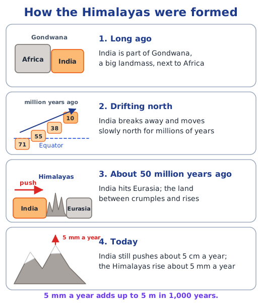
The push has not stopped. India still moves into Asia about 5 cm a year, slower than your hair grows. So the Himalayas are still rising, by about 5 mm a year. That sounds tiny, but in a thousand years it adds up to 5 m.
The three ranges
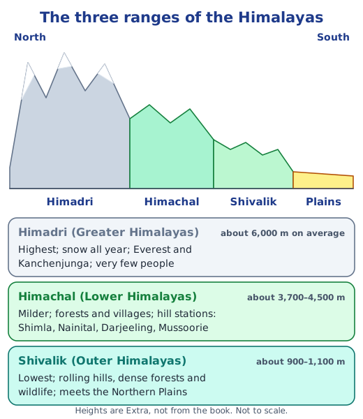
The Himalayas are grouped into three ranges, from north to south:
- The Himadri, or Greater Himalayas, form the tallest, roughest part, with peaks such as Mount Everest and Kanchenjunga. Snow covers them all year, life is hard and there are few settlements.
- The Himachal, or Lower Himalayas, lie to the south and have a milder climate, so plants, animals and people thrive. Hill stations such as Shimla, Nainital, Mussoorie and Darjeeling are here.
- The Shivalik Hills, or Outer Himalayas, are the lowest range: rolling, forested foothills full of wildlife that lead down to the Gangetic Plains.
The Water Tower of Asia
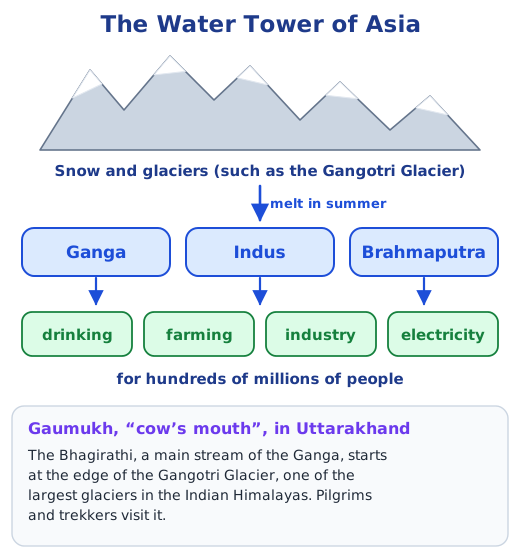
In summer the snow and glaciers melt and feed great rivers: the Ganga, the Indus and the Brahmaputra. With their tributaries, they give water for drinking, farming and industry to hundreds of millions of people, which is why the Himalayas are called the Water Tower of Asia. The Bhagirathi, a main stream of the Ganga, begins at Gaumukh, ‘the cow’s mouth’, at the edge of the Gangotri Glacier in Uttarakhand, a place visited by pilgrims and trekkers.
Living in the mountains
People have adapted to the mountains in clever ways. In the western Himalayas, kath-kuni houses, also called dhajji-dewari, are built of local stone and wood that keep the home warm and help it withstand mild earthquakes. In Ladakh, yaks give milk, meat, wool and dung, and carry loads. The mountains are also sacred to many people, and temples and monasteries stand among the peaks. Himachal Pradesh’s Great Himalayan National Park, a UNESCO World Heritage Site, protects the Himalayan monal, the snow leopard and many other species, with help from the villages inside it.
Why it matters
The Himalayas give India water, shape its weather and form a natural wall in the north. See how they fit with the rest of the land in physical features of India, follow the rivers to the sea in coastlines and islands, and find every textbook answer in the NCERT solutions for Chapter 1; see all of the Chapter 1 notes.
Practice
-
What does the word Himalaya mean?
Show answer
Answer: (b) Abode of snow
-
Which range has hill stations such as Shimla and Nainital?
Show answer
Answer: (b) Himachal
-
The Himalayas formed when India collided with:
Show answer
Answer: (c) Eurasia
-
Why are the Himalayas called the Water Tower of Asia?
Show answer
Answer: Their snow and glaciers melt in summer and feed great rivers such as the Ganga, the Indus and the Brahmaputra. These rivers and their tributaries give water for drinking, farming and industry to hundreds of millions of people.
-
How do kath-kuni houses suit the western Himalayas?
Show answer
Answer: They are built from local stone and wood laid in layers. The thick walls keep the house warm in the cold, and the mix of wood and stone helps the house survive mild earthquakes.
Questions students ask
How were the Himalayas formed?
India was once part of a large landmass called Gondwana, next to Africa. It broke away and slowly moved north. About 50 million years ago it collided with Eurasia, and the land caught between them buckled and was pushed upwards, the way a carpet wrinkles when you push it. The folded rock layers can still be seen in the mountains.
What are the three ranges of the Himalayas?
The Himadri or Greater Himalayas are the highest, snow-covered all year, with peaks like Mount Everest and Kanchenjunga. The Himachal or Lower Himalayas are lower and milder, with forests, villages and hill stations. The Shivaliks or Outer Himalayas are the lowest foothills, with rolling hills, dense forests and wildlife, next to the plains.
Which countries do the Himalayas cross?
Six Asian countries: Afghanistan, Pakistan, India, China, Nepal and Bhutan. Many of their peaks are above 8,000 m and are known together as the Eight Thousanders; the highest, Mount Everest, is about 8,849 m (Extra).
Stuck on a question?
Take a photo and Lagnever AI explains it step by step. Try it for 7 days for ₹2.
Get it on Google Play Open in browser
For parents: after the trial, the plan renews monthly by UPI or card autopay. You can cancel anytime in the app.