
Physical features of India: from the mountains to the sea
Answer in short
India’s main physical features are the Himalayan mountains in the north, the flat and fertile Northern Plains, the Thar Desert with the Aravalli Hills to its east, the Peninsular Plateau between the Western and Eastern Ghats, the coastal plains along both seas, and the islands. Together they make India one of the most varied countries in the world.
Stuck on a question? Take a photo and Lagnever AI explains it step by step. Try it for 7 days for ₹2. Get it on Google Play
India’s place in the world
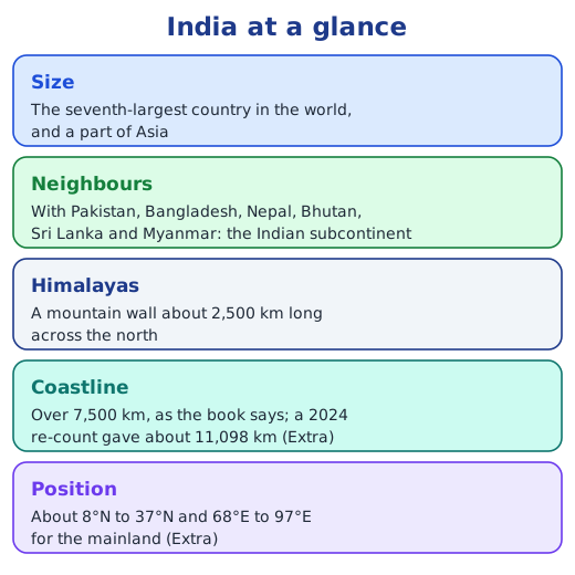
India, a part of Asia, ranks seventh in the world by area. Its mainland stretches roughly from 8°N to 37°N and from 68°E to 97°E (Extra). Mountains in the north, a desert and a sea in the west, the ocean in the south and a bay in the east set it apart from the rest of the continent. A useful way to study it is region by region.
From north to south
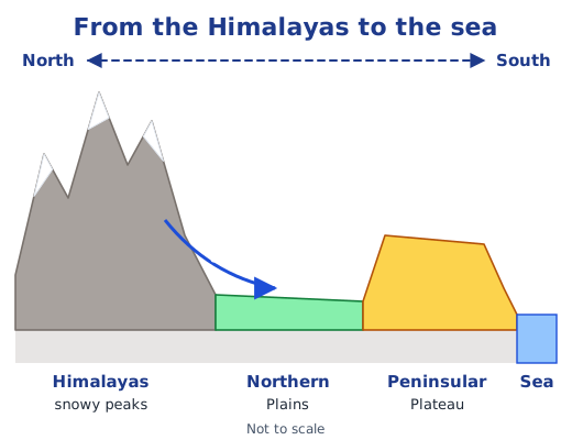
If you could cut India from north to south and look at the cut edge, you would see high mountains first, then low, flat plains, and then a raised plateau that drops to the coast. The physical map at the end of the textbook shows the same thing in colour: each shade in its legend stands for a range of heights.
The mountains of the north
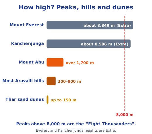
The Himalayas run for about 2,500 km and include many peaks above 8,000 m. They are young mountains, still rising as India pushes into Asia. Their snow and glaciers feed great rivers, and their three ranges, the Himadri, Himachal and Shivalik, step down from snowy peaks to forested foothills. In the far north, Ladakh is a cold desert, dry and freezing, with salty lakes and bare, moon-like slopes.
The Northern Plains
Between the Himalayas and the plateau lie the Gangetic or Northern Plains, built by the Ganga, the Indus, the Brahmaputra and their many tributaries. The rivers spread fine, mineral-rich soil, so the land is very fertile. That is why the plains are crowded with farms, villages and cities, and why roads and railways cross them easily.
The Thar Desert and the Aravallis
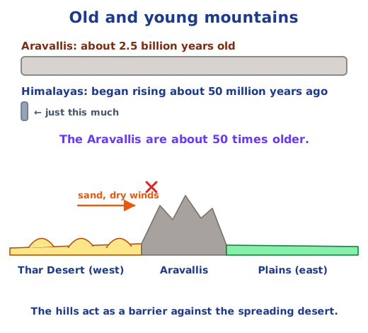
West of the plains is the Thar Desert, spread across Rajasthan, Gujarat, Punjab and Haryana. Wind shapes its sand into dunes up to 150 m high; water is scarce, so people have learnt to store rainwater and use very little. Along its eastern edge run the Aravalli Hills. Once tall mountains, they have been worn down over about 2.5 billion years to hills mostly 300 to 900 m high, with Mount Abu rising over 1,700 m. They hold back the desert and are rich in minerals.
The Peninsular Plateau
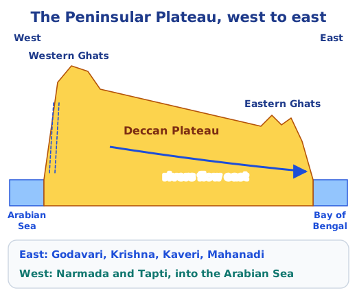
The south of India is an old, triangular plateau with water on three sides. The Western Ghats, called the Sahyadri in the north, are tall and continuous and catch heavy monsoon rain, which pours down their sides as waterfalls. The Eastern Ghats are low and split into separate hills. Between them lies the Deccan Plateau, which tilts gently east. So the Godavari, Krishna, Kaveri and Mahanadi flow east into the Bay of Bengal, while the Narmada and Tapti flow west into the Arabian Sea. The plateau holds coal and other minerals, thick forests and many tribal communities.
Coasts, islands and the Northeast
Coastal plains line both sides of the peninsula: a narrow one in the west with estuaries, and a wider one in the east with deltas and lagoons. Beyond them lie the coral islands of Lakshadweep and the volcanic Andaman and Nicobar Islands. In the east, the Sundarbans delta and the rainy Garo, Khasi and Jaintia hills complete the picture.
Why it matters
Each physical feature shapes how people live: what they grow, how they build houses, how they save water and how they travel. Read how the mountains formed in the Himalayas, explore the seaside in coastlines and islands, and find every textbook answer in the NCERT solutions for Chapter 1; see all of the Chapter 1 notes.
Practice
-
Which physical feature lies between the Himalayas and the Peninsular Plateau?
Show answer
Answer: (b) The Northern Plains
-
The northern part of the Western Ghats is also called:
Show answer
Answer: (b) the Sahyadri
-
Which river flows west into the Arabian Sea?
Show answer
Answer: (c) Narmada
-
Why do so many people live in the Northern Plains?
Show answer
Answer: The land is flat and the soil is fertile, because Himalayan rivers bring water and minerals. Farming does well, water is easy to get, and roads and railways are easy to build, so villages, towns and cities have grown there.
-
How do the Aravalli Hills help the land to their east?
Show answer
Answer: They act as a natural barrier between the Thar Desert and the plains, stopping the desert from spreading east. They also hold minerals such as marble, granite, zinc and copper.
Questions students ask
What are the physical divisions of India?
The chapter groups India into five regions: the Himalayan mountain zone, the Ganga–Indus plains, the Thar desert region, the southern peninsula with its plateau, Ghats and coasts, and the islands. The coastal plains and the hills of the Northeast are also described.
What is the difference between a plateau and a plain?
Both have a fairly flat surface, but a plateau rises above the land around it and often has steep sides, like the Deccan Plateau between the Ghats. A plain is low, flat land, often built by rivers, like the Northern Plains.
Which is the oldest landform described in the chapter?
The Aravalli Hills, about 2.5 billion years old, rank among the oldest mountains anywhere on Earth. The Peninsular Plateau is also a very old land formation, while the Himalayas are young mountains that are still rising.
Stuck on a question?
Take a photo and Lagnever AI explains it step by step. Try it for 7 days for ₹2.
Get it on Google Play Open in browser
For parents: after the trial, the plan renews monthly by UPI or card autopay. You can cancel anytime in the app.