
India’s coastlines and islands
Answer in short
India’s coastline is over 7,500 km long. The narrow west coast, from Gujarat to Kerala, has short, swift rivers that end in estuaries; the wider east coast has big rivers that build fertile deltas, and lagoons such as Chilika. India also has two island groups: the coral islands of Lakshadweep and the volcanic Andaman and Nicobar Islands.
Stuck on a question? Take a photo and Lagnever AI explains it step by step. Try it for 7 days for ₹2. Get it on Google Play
A coastline full of surprises
India’s coastline is over 7,500 km long, as the book says (Extra: a 2024 re-count using more detailed charts put it at about 11,098 km). Along it you find golden and black-sand beaches, rocky cliffs, green forests, coral reefs and busy ports. The two sides of the peninsula are quite different, because of the hills behind them and the rivers that cross them.
The west coast
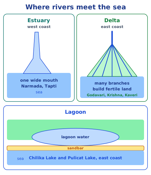
The west coast runs from Gujarat to Kerala, through Maharashtra, Goa and Karnataka. Here the Western Ghats stand close to the Arabian Sea, so the coastal strip is narrow. Rivers that start in the Ghats are short and flow fast; they do not have time to build big deltas, so they meet the sea through estuaries, single wide mouths where river water and sea water mix. The Narmada and Tapti estuaries are the largest. The coast is also cut by coves and creeks, and its ports and cities, such as Mumbai, India’s financial centre, have been centres of trade for thousands of years.
The east coast
The east coast runs from the Ganga delta down to Kanyakumari, with the Eastern Ghats behind it and the Bay of Bengal in front. Its plains are wider, and its rivers are long and slow by the time they reach the sea. They drop their load of silt and split into many smaller streams, called distributaries, building deltas: fan- or triangle-shaped areas of very fertile land. The Mahanadi, Godavari, Krishna and Kaveri deltas are rich farmland.
The east coast also has lagoons, bodies of water cut off from the sea by a natural barrier such as a sandbar. Chilika Lake and Pulicat Lake are well-known examples.
Two groups of islands
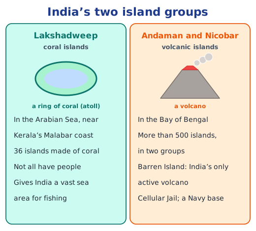
India has islands in both the Bay of Bengal and the Arabian Sea. Lakshadweep, near the Malabar coast of Kerala, is an archipelago of 36 islands made of coral; people live on only some of them. Its islands also give India a vast area of sea for fishing, exploring resources and protecting the environment.
The Andaman and Nicobar Islands are a much bigger archipelago of more than 500 volcanic islands, big and small, in two groups. Far out in the Bay of Bengal, they act like India’s outposts on the ocean. They have rich plants and animals and coral reefs, and Barren Island is India’s only active volcano. The Cellular Jail in the Andamans, where many freedom fighters suffered harsh imprisonment, is kept today as a memorial to their sacrifice.
The Sundarbans
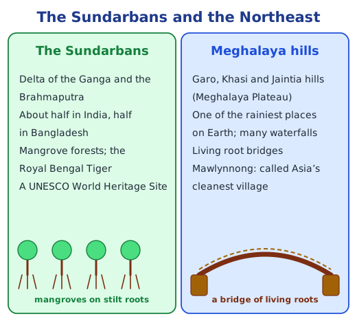
Where the Ganga and the Brahmaputra and their tributaries reach the Bay of Bengal, they form a huge delta. Its southern part is the Sundarbans, a maze of rivers, sea and islands covered in mangrove forest. About half of it lies in India and the rest in Bangladesh. It is a UNESCO World Heritage Site and where many species live, among them the Royal Bengal Tiger.
Why it matters
Coasts and islands give India fish, ports, trade, tourism and a large share of the ocean, and their deltas feed millions of people. See how the rest of the land fits together in physical features of India and the Himalayas. Every textbook question is answered in the NCERT solutions for Chapter 1; see all of the Chapter 1 notes.
Practice
-
Which river forms one of the largest estuaries on the west coast?
Show answer
Answer: (b) Narmada
-
Chilika Lake is an example of:
Show answer
Answer: (b) a lagoon
-
Lakshadweep is made up of:
Show answer
Answer: (b) coral islands in the Arabian Sea
-
Why are the east coast deltas good for farming?
Show answer
Answer: The rivers drop the fine, mineral-rich silt they carry when they reach the sea, building up flat land with very fertile soil. Water from the rivers and their branches is also close at hand.
-
Why are the Andaman and Nicobar Islands important for India?
Show answer
Answer: They sit far out in the Bay of Bengal, so they work like outposts that watch over the ocean, with Navy bases nearby. They also have rich wildlife and coral reefs, and the Cellular Jail, where freedom fighters were imprisoned.
Questions students ask
What is the difference between the west and east coasts of India?
The west coast, from Gujarat to Kerala, is narrow because the Western Ghats come close to the sea; its short, fast rivers end in estuaries, creeks and coves. The east coast, from the Ganga delta to Kanyakumari, is wider, and its big rivers form large deltas and lagoons.
What is a delta, and which rivers form deltas in India?
A delta is a fan- or triangle-shaped piece of land built where a river slows down, drops its sediment and splits into many smaller streams before entering the sea. On the east coast, the Mahanadi, Godavari, Krishna and Kaveri form deltas, and the Ganga and Brahmaputra form the huge delta of the Sundarbans.
Which is the only active volcano in India?
Barren Island in the Andaman and Nicobar Islands. It still erupts from time to time, sending smoke and lava into the sky.
Stuck on a question?
Take a photo and Lagnever AI explains it step by step. Try it for 7 days for ₹2.
Get it on Google Play Open in browser
For parents: after the trial, the plan renews monthly by UPI or card autopay. You can cancel anytime in the app.