
NCERT Solutions Class 7 Social Science Part 2 Chapter 2: India and Her Neighbours
Answers to every question in Part 2 Chapter 2, India and Her Neighbours, of Exploring Society: India and Beyond (2026-27): the Big Questions, every Let’s Explore and figure question, and all 8 questions and activities. The page numbers match the book (pages 29–60). Short notes: Part 2 Chapter 2 notes.
The Big Questions (page 29)
1. What defines a neighbour? Is it just shared land borders? No. Traditionally a neighbour is a country with a shared land boundary, but countries across a shared sea are neighbours too, such as Sri Lanka and the Maldives for India. Neighbours are also defined by shared history, culture, trade and the problems they face together.
2. How do geography and history shape India’s relations with her neighbours? Geography decides who is close and how people can travel: the Himalayas separate India and China, open plains and rivers join India with Nepal and Bangladesh, and the seas link India with Sri Lanka, the Maldives and Southeast Asia. History adds both bonds and wounds: Buddhism, epics and trade routes created deep ties, while the Partition of 1947 left a difficult relationship with Pakistan.
3. How are India and her neighbours connected today? Through trade, ports and highways, energy projects such as Bhutan’s hydropower, open borders, pilgrimages, films and music, groups such as SAARC, and cooperation in disasters, such as the tsunami early warning network.
Let’s Explore: the waters around India (page 30)
Name the three large water bodies around India. The Arabian Sea to the west, the Bay of Bengal to the east and the Indian Ocean to the south.
The Kartarpur Corridor (page 36)
Can the Kartarpur Corridor be a model for peace and dialogue? Yes, in a small way. It shows that even neighbours with a difficult relationship can agree on a practical step that matters to ordinary people: pilgrims need only a permit, not a visa, to visit Guru Nānak’s resting place. Such steps build trust, and similar corridors for other shrines, trade or families could follow. But a corridor alone cannot end conflict; lasting peace also needs an end to terrorism and steady dialogue.
Bhutan’s emblem (page 40)
What other elements of Bhutan’s emblem look familiar? Besides the two dragons, the emblem shows a lotus and crossed vajras, the thunderbolt symbols of Vajrayāna Buddhism, with a jewel at the top. The lotus, India’s national flower, and the vajra are also common in Indian Buddhist and Hindu art. (Extra: the description of the emblem’s parts.)
Let’s Explore: Bangkok’s airport (page 51)
The airport is named Suvarnabhumi. Does it remind you of something? Yes. Suvarṇabhūmi, the ‘golden land’, is what ancient Indian traders called the lands of Southeast Asia. The churning of the ocean sculpture in the same airport also comes from an Indian story.
Let’s Explore: Tamil in Singapore (page 53)
Tamil is one of Singapore’s official languages. What does that suggest? That south India and Singapore have long and close ties. Many traders and workers from Tamil Nadu settled there over the centuries, so about 9% of Singapore’s residents today are of Indian origin, many of them Tamil speakers, and their language is respected officially.
Questions and activities (page 60)
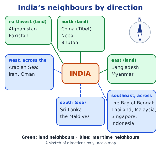
1. Who is a maritime neighbour? Give two examples for India. A maritime neighbour is a country that faces another across a shared sea or ocean, even if no land border joins them. Examples: Sri Lanka, only about 32 km from India across the Palk Strait, and the Maldives, about 130 km from Minicoy in Lakshadweep. Indonesia, Thailand and Oman are others.
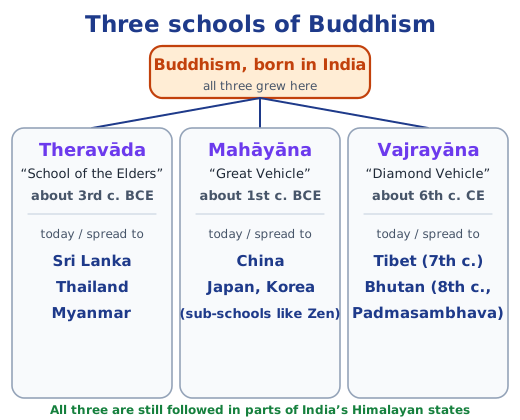
2. How has Buddhism linked India with her neighbours? Give examples.
- It travelled to China in about the 1st century CE; Faxian and Xuanzang came to study in India, and Bodhidharma, Dharmakṣhema and Kumārajīva taught in China.
- Sri Lanka received it in the 3rd century BCE from Mahendra and Sanghamitrā.
- Guru Padmasambhava took Vajrayāna to Bhutan in the 8th century, and Bhutanese pilgrims visit Bodh Gaya, Rajgir and Nalanda.
- Theravāda is followed in Sri Lanka, Thailand and Myanmar, and Mahāyāna spread to China, Japan and Korea.
- In Myanmar, India restored the Ananda temple at Bagan and gifted a Buddha replica to the Shwedagon Pagoda; the Bamiyan Buddhas in Afghanistan and the Borobudur Stūpa in Indonesia show the same reach.
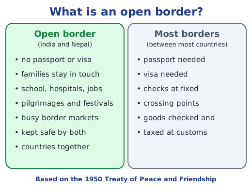
3. What does an open border policy mean? How does the India–Nepal open border affect people near it? An open border is one that the people of both countries can cross without a passport or visa. Along the India–Nepal border, families living on both sides stay connected; people cross daily for school, hospitals and work; pilgrims visit shrines such as Paśhupatinātha; and border towns have busy markets and trade. Both governments work together so that the open border is not misused.
4. Explain, with an example, that being neighbours is not just about geography. Good neighbours also share history, culture and help. Thailand has no land border with India, yet its kingdoms were named after Dvārakā and Ayodhyā, its kings are named Rama, and the Rāmāyaṇa appears in its royal ceremonies. The Maldives, across the sea, has Dhivehi words from Sanskrit and Tamil, and India was its first responder in the 2004 tsunami and the 2014 water crisis. Working together for everyone’s benefit is what makes a good neighbour.
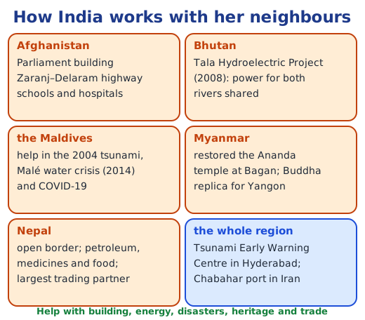
5. How has India helped smaller countries in her neighbourhood? Give examples.
- Afghanistan: the Parliament building, the Zaranj–Delaram highway, and support for education and health care.
- Bhutan: the Tala Hydroelectric Project, whose power helps both countries.
- The Maldives: quick help in the 2004 tsunami, the 2014 Malé water crisis and COVID-19.
- Myanmar: restoring the earthquake-damaged Ananda temple at Bagan.
- Nepal: an open border for work, study and health care, and supplies of petroleum, medicines and food.
- The region: the Tsunami Early Warning Centre in Hyderabad, which also alerts neighbours.
6. How do shared challenges become chances to cooperate? Were there examples in the chapter? Yes. A problem that crosses borders can only be solved together, so it pushes neighbours to cooperate.
- After the 2004 tsunami, India, Indonesia, Sri Lanka, Thailand and others built a shared warning network.
- India and Bangladesh jointly protect the Sundarban, which shields both from cyclones as seas rise.
- The Maldives, threatened by rising seas, joined the International Solar Alliance.
- India and Bhutan turned shared rivers into hydropower.
- India and Indonesia work together against piracy and for safe sea lanes.
- India and Nepal work together to keep their open border safe.
7. If borders were drawn only by culture and connections, how would the map look? It would show overlapping zones instead of sharp lines. A Bangla-speaking zone would join West Bengal and Bangladesh, and a Punjabi zone would cross the India–Pakistan border. A Tamil zone would reach Sri Lanka, Singapore and Malaysia, and a Buddhist zone would link Ladakh, Sikkim and Bhutan with Tibet, Myanmar, Thailand and Sri Lanka. A Rāmāyaṇa zone would stretch to Thailand and Indonesia, and an Indian Ocean trade zone would run from Oman to Indonesia. Many places would belong to several zones at once, showing how connected the region is.
8. Activities on blank maps.
- Label India’s neighbours: the land neighbours Pakistan, Afghanistan, China, Nepal, Bhutan, Bangladesh and Myanmar, and the maritime neighbours Sri Lanka, the Maldives, Thailand, Malaysia, Singapore, Indonesia, Iran and Oman. Use the official map in your textbook or atlas for correct borders.
- Arrows for cultural flows: for example, Buddhism from India to Sri Lanka, Myanmar, Thailand, China and Bhutan; the Rāmāyaṇa to Thailand and Indonesia; south Indian food and dance to the Maldives; Bangla shared with Bangladesh; Holi, Daśhain and Tihar shared with Nepal; and the Persian language from Iran to India.
- Borders of friendship: draw the Ganga–Brahmaputra rivers shared with Bangladesh, Bhutan’s rivers that give power, the Uttarāpatha to Afghanistan, the spice routes across the Bay of Bengal, and the Trilateral Highway to Thailand.
- Flags: collect the flags and note what you see. (Extra) Several carry a crescent, such as those of Pakistan, Malaysia, Singapore and the Maldives. Red and white are common, as on the flags of Indonesia and Singapore. Nepal’s is the only national flag that is not a rectangle, Bhutan’s shows a dragon, and Sri Lanka’s shows a lion holding a sword.
Practice
-
Which neighbour shares an open border with India?
Show answer
Answer: (c) Nepal
-
Which school of Buddhism is followed mainly in Sri Lanka, Thailand and Myanmar?
Show answer
Answer: (a) Theravāda
-
The Tala Hydroelectric Project was built with India’s support in:
Show answer
Answer: (b) Bhutan
-
The Maldives lies about 130 km from which Indian island?
Show answer
Answer: (a) Minicoy
-
Name two maritime neighbours of India and say how each is linked to India.
Show answer
Answer: Sri Lanka, about 32 km away across the Palk Strait, received Buddhism from Mahendra and Sanghamitrā. Oman, across the Arabian Sea, traded copper with the Harappans over 5,000 years ago and is India’s nearest defence partner in the Gulf.
Stuck on a question?
Take a photo and Lagnever AI explains it step by step. Try it for 7 days for ₹2.
Get it on Google Play Open in browser
For parents: after the trial, the plan renews monthly by UPI or card autopay. You can cancel anytime in the app.