
NCERT Solutions Class 8 Social Science Part 2 Chapter 7: India’s Urban Landscape
Answers to the Big Questions, every Let’s Explore, Think About It and Let’s Remember box, and all fourteen Questions and activities in Chapter 7, India’s Urban Landscape, of Exploring Society: India and Beyond, Grade 8 Part 2. Page numbers follow the book (pages 191–214). Short notes: Part 2 Chapter 7 notes.
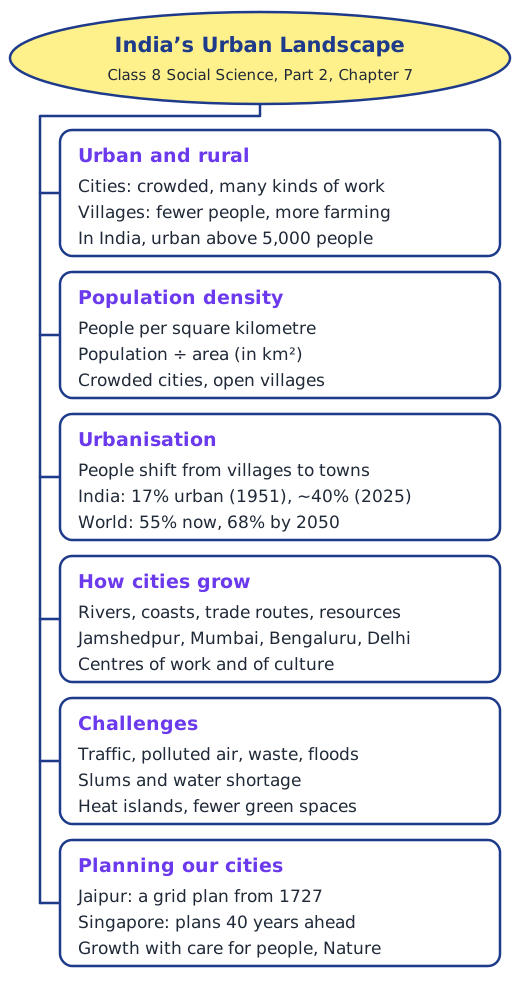
The Big Questions (page 191)
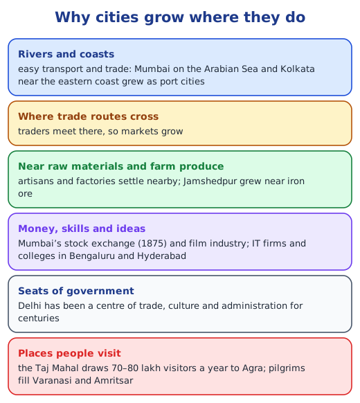
1. Why do cities become centres of so many kinds of work? Because of their location and what gathers there. Rivers, coasts and trade routes bring trade and markets; nearby raw materials bring artisans and factories, as iron ore did for Jamshedpur; banks, firms and colleges bring skilled jobs, as in Mumbai and Bengaluru; government offices bring work to capitals such as Delhi; and monuments and holy places bring visitors to Agra, Varanasi and Amritsar. Once some jobs arrive, people follow, and more businesses come to serve them.
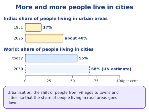
2. How does urbanisation change people’s lives? It brings more kinds of jobs, education, healthcare, entertainment and a mix of cultures, and new ideas grow where many people meet. But it can also mean crowded homes, long journeys, polluted air, costly housing, and slums for those who cannot afford a proper home. Villages change too, as young people leave for the cities.
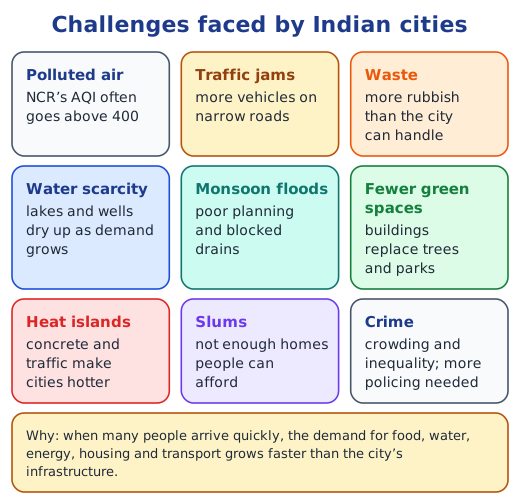
3. What problems do cities face in this century? Polluted air, traffic jams, waste, water scarcity, floods in the monsoon, the loss of green spaces, heat islands, the growth of slums and crime, all made harder by a changing climate.
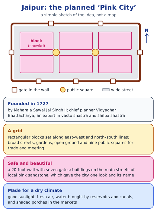
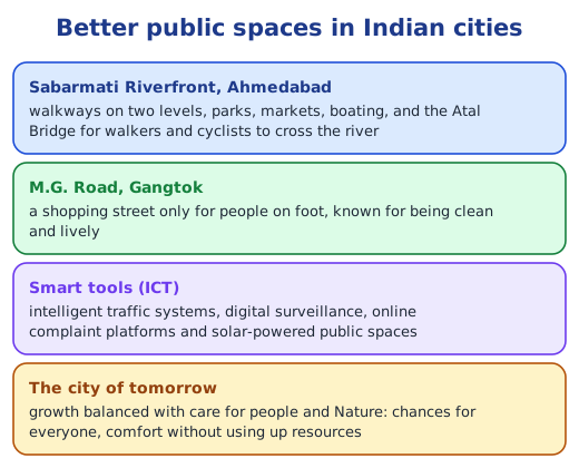
4. How can good planning make city life better? Planners decide where homes, jobs, parks, schools and hospitals go, how people travel and how streets stay safe, and they update the plan as needs change. Jaipur’s grid plan from 1727 still works; Singapore plans 40 years ahead and updates its plan every 5 years; and Ahmedabad’s Sabarmati Riverfront and Gangtok’s M.G. Road show how public spaces can be improved.
Let’s Explore, Think About It and Let’s Remember (pages 192–203)
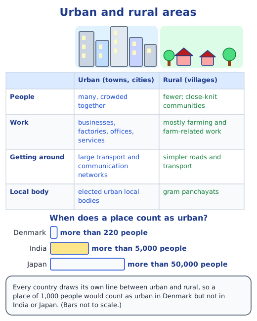
Village, town or city? (page 192). A sample answer from a student in a small town: “I live in a town. It has a market, a bus stand, a few banks, schools and a hospital, and a municipal council looks after it, but there are fields all around it.” Ways to tell urban from rural areas: how many people live there and how close together; whether most people farm or work in shops, offices and factories; how many businesses there are; how good the transport and communication links are; and whether a gram panchayat or an urban local body runs the place.
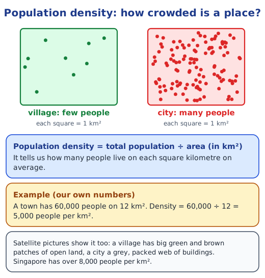
Two satellite views in Haryana (page 193). The village has a low population density: it is mostly open fields with a few homes, so few people live on each square kilometre. Gurugram has a very high density: buildings and roads cover almost all the land. The difference exists because the city has offices, factories, shops and services that draw many people to live close to their work, while village land is used for farming, which needs space and fewer workers per km².
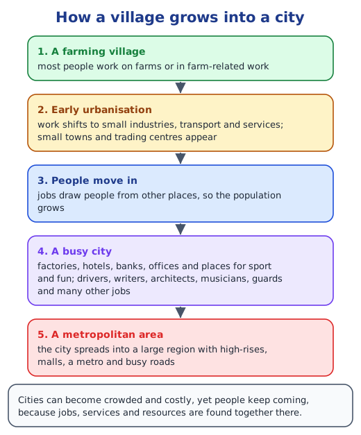
Electronic City, Bengaluru, 2012 and 2025 (page 194). In 2025 there are many more buildings and far less open green land, the built-up area has spread on every side, and a metro station has appeared on the main road. Likely causes: technology companies set up offices there, jobs drew people from across India, and they needed homes, shops, schools and transport, so empty plots and farmland were built over.
Talking to older people about change (page 195). A sample questionnaire: (1) How long have you lived here? (2) What did this place look like when you were young? (3) What are the biggest changes you have seen? (4) Has it grown bigger? Why, do you think? (5) What do you miss about the old days? (6) What do you like about life here now? Typical findings: more people, buildings and vehicles; better roads, hospitals and phones; less open land, more noise and pollution, and neighbours who know each other less well. Reasons often given: new jobs, people moving in, and higher incomes. Present the answers to the class as a short talk with a chart or photos.
Surat (page 198). As the Grade 7 chapter Understanding Markets shows, Surat has traded from its west-coast port for centuries, and its port, highways and railways bring in raw cotton and carry its cloth and diamonds across India and abroad. Cotton from nearby markets in Gujarat and Maharashtra, thousands of weaving, dyeing and garment units, a large wholesale market and many skilled artisans, including diamond cutters and polishers, together made it a hub. Businesses of one kind clustering in one city helped each other grow.
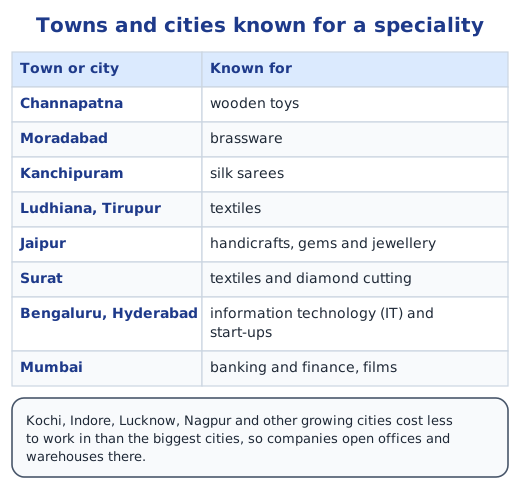
Towns near you (page 203). A sample: Lucknow is known for its Awadhi food, such as kebabs and biryani, for chikan embroidery and for polite speech; Kolkata for its Durga Puja, sweets such as rosogolla and its book fair; Madurai for the Meenakshi Temple festivals and jasmine flowers. Find two or three such features for towns near you and share them in class.
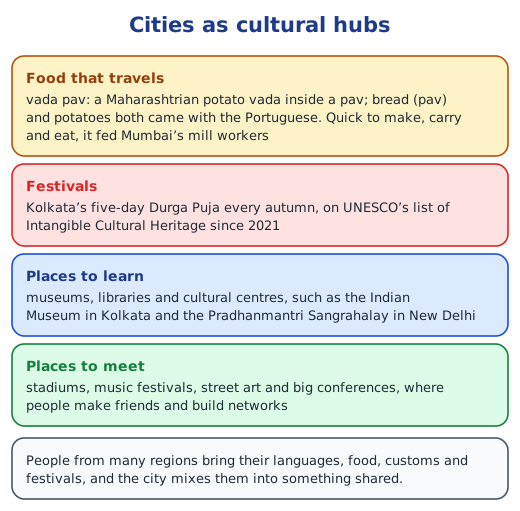
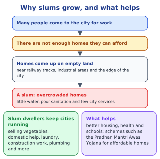
The other side of the city (page 203). Yes: next to tall buildings and busy roads there are slums, piles of waste, flooded streets and polluted air. People living in urban slums face crowded, unsafe homes; little clean water and few toilets; drains that overflow in the rain; diseases that spread easily; long trips to work; no secure ownership of their homes; and children who find it harder to study.
Questions and activities (pages 212–214)
Q1. “What are some common features of cities?” Cities have large populations living close together, so their population density is high. People do many kinds of work in industry, trade and services rather than farming. There are many businesses, markets and offices, government institutions, and big transport and communication networks such as roads, buses, metro and railways. Cities have schools, colleges, hospitals, museums, stadiums and other facilities, and an elected urban local body runs them. They also mix people of many regions, languages and cultures.
Q2. “Can you think of a city or town near you that has grown in population? What could be the underlying reasons for the urban migration?” A sample: Gurugram, near Delhi, has grown from a small town into a large city. Reasons people move to such places: jobs in offices, factories, shops and construction; colleges and schools; better hospitals; more services, such as electricity, water and transport; and the hope of higher incomes. Some people are pushed out of villages by too little land, low farm incomes, droughts or floods, and a lack of facilities.
Q3. “With reference to the epigraph at the beginning of the chapter, who are the participants in the making of the city and what could be their contribution?” Jane Jacobs says a city can give something to everyone only if everyone helps to make it. The participants include residents, who keep their streets clean, save water, follow rules and vote; workers, including street vendors, domestic helpers, construction workers and plumbers, who keep daily life running; businesses and industries, which give jobs and pay taxes; the urban local body and government, which provide services and make rules; planners, architects and engineers, who design the city; Resident Welfare Associations and non-profit groups, which take on local work, such as Bengaluru’s lake revivals; and children, elders and people with disabilities, whose needs and ideas make the city fair for all.
Q4. “In what ways can urbanisation affect rural areas? Do cities also depend on rural areas? If yes, how? In what ways can rural and urban areas help each other develop?” Urbanisation draws young workers out of villages, so farms may be short of labour, and cities spread onto village farmland and forests. On the other hand, migrants send money home, villages near cities get better roads and services, and farmers find bigger markets. Yes, cities depend on villages for food grains, vegetables, milk and fruit, raw materials such as cotton, water from rivers and reservoirs, and many workers. They can help each other: villages supply food and raw materials while cities buy them at fair prices; cities provide hospitals, colleges, technology and jobs; good roads and transport link the two; and small industries and services set up in villages can create jobs there, so that people do not have to leave.
Q5. “What is urban planning? What are the risks of ignoring sustainable urban planning as cities expand into villages and forest areas?” Urban planning is deciding how land in a town or city is used, where homes, businesses, parks and public facilities go, how people travel and how they stay safe, so that the city works well for its people now and in the future. If cities grow without sustainable planning, forests, farmland, lakes and wetlands are lost; water becomes scarce as groundwater is overused; unplanned colonies and slums come up without water, drains or waste collection; floods get worse when lakes and drains are built over, as in Bengaluru; traffic and pollution increase; heat islands make summers hotter; wildlife loses its home; and people in the villages lose their land and livelihoods.
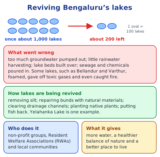
Q6. “Observe your own neighbourhood. What signs of good or poor planning do you notice? How do they affect daily life for you and others?” A sample observation. Signs of good planning: a park within walking distance, a school and a clinic nearby, footpaths and street lights, a bus stop close by, and regular waste collection. These make it easy and safe to walk to school, play outside and reach a doctor. Signs of poor planning: narrow lanes jammed with parked vehicles, no footpaths, drains that overflow in the rain, garbage on empty plots and no space for children to play. These cause traffic, accidents, waterlogging, mosquitoes and illness, and they make life hardest for children, elders and people with disabilities.
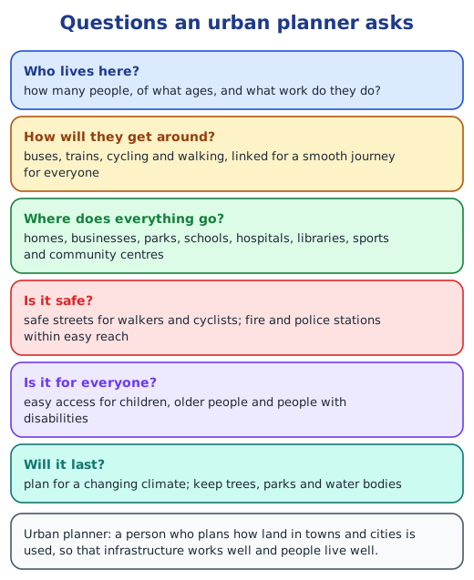
Q7. “Imagine you are an urban planner, what are the things you would consider to plan a city? Do groups like children, the elderly, and people with disabilities get easy access to parks, toilets, and public transport? What changes would you introduce to make it more inclusive?” I would consider how many people live in the city and what work they do; housing for every income group; transport linking buses, trains, cycling and walking; where to place homes, workplaces, schools, hospitals, markets and parks; water, sewerage, electricity and waste; safety, with lit streets and nearby fire and police stations; and green spaces and water bodies for a changing climate. In many cities these groups do not get easy access: footpaths are broken or blocked, buses have high steps, toilets are few and often unusable for wheelchair users, and parks are far away. Changes I would make: level footpaths with ramps and curb cuts; low-floor buses, lifts at metro stations and audio announcements; clean, accessible toilets in every market and park; benches and shade at regular intervals; small parks and play areas in every neighbourhood; and signs in large print and Braille.
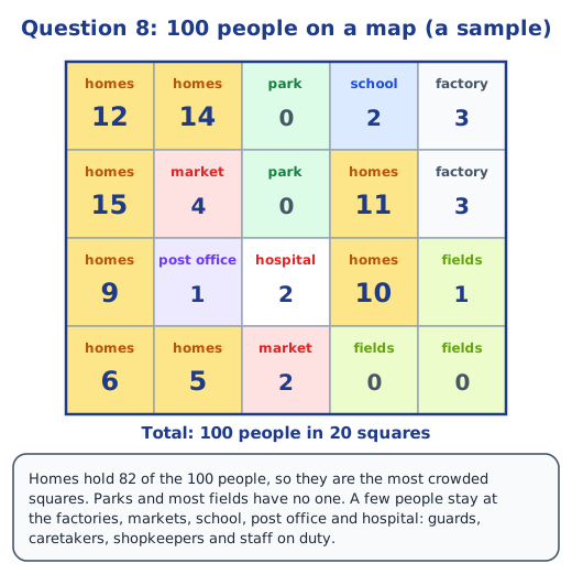
Q8. “Suppose your town, village or city has 100 people. Draw a rough map of the place on a graph paper. Imagine each square on the paper represents a specific area of the place, like residential neighbourhoods, parks, schools, factories, post offices and so on. Now, distribute the 100 people throughout the area. You can decide where the people will live, whether they all live in the residential areas, or some live in the commercial or industrial areas. Write this number in each of the boxes. In your depiction of the map, which areas are heavily populated and which are not? What were the reasons behind your choices of allocation of people?” A sample map with 20 squares is below. Homes hold 82 of the 100 people, so the residential squares are the most crowded, especially those near the market and school, where people want to live close to shops and classes. Parks and fields are not populated, because they are open spaces. A few people are placed at the factories, markets, school, post office and hospital: guards, caretakers, shopkeepers who live above their shops and staff on duty. Your own map will look different.
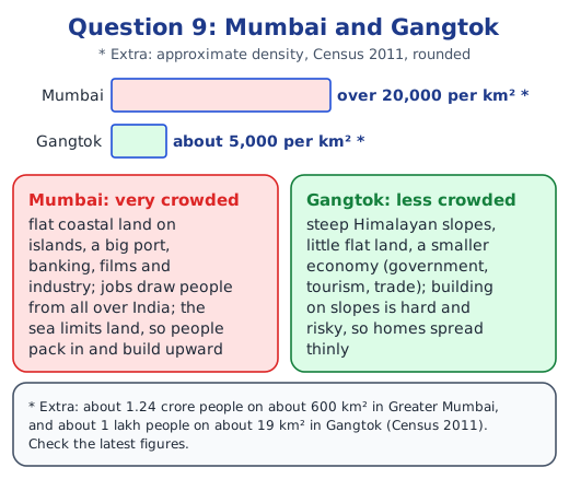
Q9. “Observe the satellite view of Mumbai and Gangtok, respectively. Find out their population density and likely reasons for the difference.” The satellite view of Mumbai shows land covered with buildings right up to the sea, while Gangtok shows small clusters of buildings among forested hills. Extra, from the Census of 2011 (not in the chapter; check the latest figures): Greater Mumbai had about 1.24 crore people on about 600 km², over 20,000 people per km², and Gangtok about 1 lakh people on about 19 km², roughly 5,000 per km². Likely reasons: Mumbai is a flat coastal city and a big port, India’s financial capital and home of the film industry, so jobs draw people from all over the country, while the sea limits how far it can spread. Gangtok lies on steep Himalayan slopes with little flat land, building is harder and risky because of landslides, and its economy, based on government, tourism and trade, is much smaller.
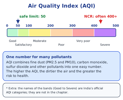
Q10. “Find out how the city of Beijing, China, tackled the problem of air pollution. Prepare a report outlining measures that can be taken in India to mitigate air pollution in cities.” Extra: these facts about Beijing are not in the chapter; check them with a teacher or in news reports. A sample report. Beijing: from the early 2010s the city switched power plants and home heating from coal to gas and electricity; closed or moved polluting factories; set stricter limits on vehicle smoke and capped the number of new cars; added metro lines and electric buses; controlled dust at building sites; put up air monitors and warned people on bad days; and worked with nearby provinces, since polluted air crosses borders. Over the next decade its fine-dust levels fell sharply. Measures for Indian cities: more and better buses and metro lines, and cleaner fuels such as CNG and electric vehicles; regular checks on vehicle pollution; covering building sites and sprinkling water on dusty roads; cleaner fuels for factories, power plants and kitchens; helping farmers deal with crop stubble instead of burning it; no burning of waste; more trees and green belts; and air-quality monitors with public alerts, with neighbouring States working together. Citizens can help by using public transport, sharing rides and saving electricity.
Q11. “Talk to a family or community member who has moved from a village to a city. Ask them the reason for the same and their experience, challenges and opportunities. How does city life compare to rural life?” A sample from an interview with an uncle who moved from a village to a city: Reason: he wanted a steady job and better schools for his children. Experience: the first months were hard; he shared a small rented room and missed his family. Challenges: high rent, long bus journeys, crowds, noise and polluted air, and fewer people who knew him. Opportunities: a regular salary, the chance to learn new skills, good hospitals and colleges, and money to send home. Comparison: city life gives more choices, services and income, but it is costly, rushed and lonely at first; village life is calmer, cheaper and close-knit, with clean air, but has fewer jobs and facilities.
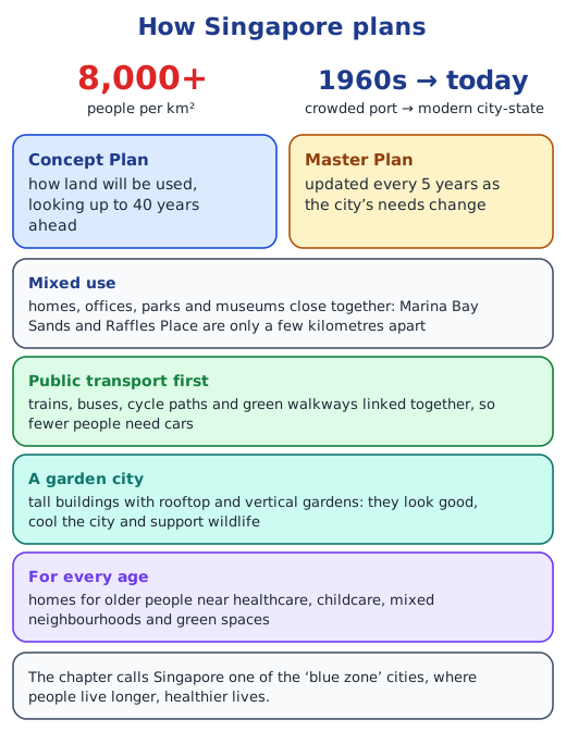
Q12. “Learn about urban planning in other cities around the world. In what ways can some of those aspects be adapted for a city near you?” From the chapter: Singapore plans land use 40 years ahead and updates its Master Plan every 5 years, keeps homes, offices and parks close together, links rail, buses, cycling and walking, and grows gardens on rooftops and walls. Extra, beyond the chapter: Curitiba in Brazil runs fast buses in their own lanes, a cheaper option than a metro; Copenhagen in Denmark has long, safe cycle lanes, so a large share of people cycle to work. Ideas for a city near you: bus-only lanes on main roads; safe footpaths and cycle lanes; parks, schools and markets within walking distance in every neighbourhood; green roofs and trees to cool the streets; and a city plan that is reviewed every few years with citizens’ ideas.
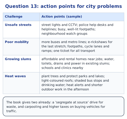
Q13. “Explore and suggest action points with respect to urban planning in cities to mitigate the challenges below and write a report. Two have been completed for you.” The challenges left to do are “Inadequate safety of residents”, “Poor mobility within the city”, “Expansion of slums” and “Heat waves during summers”; the book has already filled in waste management (a ‘segregate at source’ drive) and traffic congestion (carpooling and higher taxes on buying vehicles). Sample action points for the four are in the table below. Safety: street lights and CCTV on every road, police help desks and helplines, busy, well-lit footpaths and neighbourhood watch groups. Mobility: more buses and metro lines, e-rickshaws for the last stretch, footpaths, cycle lanes and ramps, and one ticket for all transport. Slums: affordable and rental homes near places of work, water, toilets, drains and electricity in existing slums, and schools and clinics nearby. Heat waves: plant trees and protect parks and lakes, light-coloured roofs, shaded bus stops and drinking-water points, heat alerts, and less outdoor work in the hottest hours.
Q14. “Find out about a slum rehabilitation program where people moved from slums to proper housing in your city. What do you think its possible benefits could be for the communities there?” Ask your municipal office, a local newspaper or a teacher about such a programme; many cities have them, some under the Pradhan Mantri Awas Yojana, which the chapter mentions. In some, families get new flats on the same land (in-situ redevelopment); in others, they move to new colonies. Possible benefits: safe, pucca homes that do not leak or flood; tap water, toilets, drains and electricity; fewer illnesses; a home that legally belongs to the family; a quieter, cleaner place for children to study; dignity and safety, especially for women and girls; and the chance to save and plan for the future. A good programme keeps people close to their places of work, schools and markets, so that moving does not cost them their jobs.
Practice
-
A city has 50 lakh people living on 500 km². What is its population density?
Show answer
Answer: (b) 10,000 per km²
-
Which of these did NOT cause Bengaluru’s lakes to shrink?
Show answer
Answer: (c) planting native plants
-
The Atal Bridge, for walkers and cyclists, is part of:
Show answer
Answer: (a) the Sabarmati Riverfront, Ahmedabad
-
Give two ways in which a city depends on villages.
Show answer
Answer: Villages supply the city’s food, such as grain, vegetables and milk, and raw materials such as cotton; many city workers also come from villages.
-
Why is a heat island hotter than the land around it?
Show answer
Answer: Concrete, roads and buildings soak up the sun’s heat and give it off slowly, traffic adds more heat, and there are few trees or water bodies to cool the air.
Stuck on a question?
Take a photo and Lagnever AI explains it step by step. Try it for 7 days for ₹2.
Get it on Google Play Open in browser
For parents: after the trial, the plan renews monthly by UPI or card autopay. You can cancel anytime in the app.