
Class 8 Social Science Part 2 Chapter 7: India’s Urban Landscape Notes
This chapter in five lines
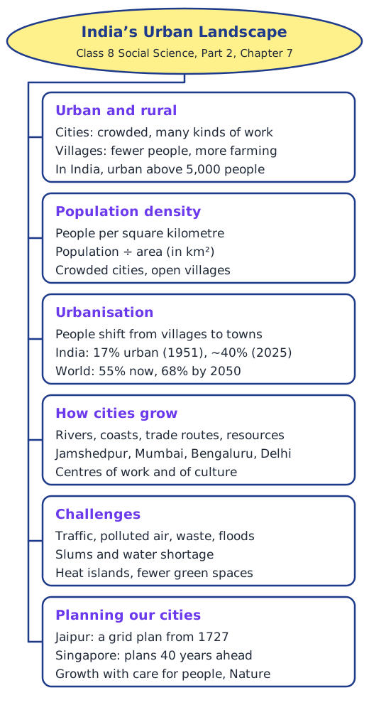
India’s Urban Landscape is about towns and cities: how they differ from villages, how crowded they are and why people keep moving to them. Cities grow near rivers, coasts, trade routes and resources and become centres of work and culture. Fast growth brings traffic, polluted air, slums and water shortages, so cities need careful, sustainable planning.
What is this chapter about?
The chapter opens with a thought from the American urbanist Jane Jacobs: a city can give something to everyone only when everyone takes part in making it. Its Big Questions ask why cities become centres of so many kinds of work, how urbanisation changes people’s lives, what problems cities face in this century, and how good planning can make city life better.
Urban or rural?
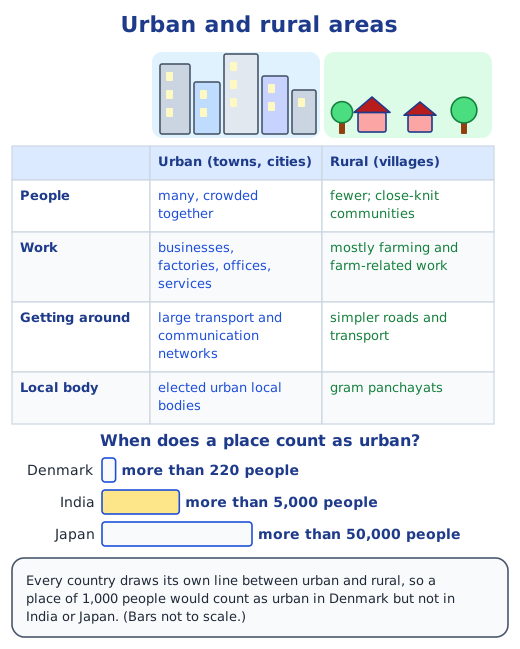
India has a long history of cities, from Harappan Dholavira, Kalibangan and Rakhigarhi to Vijayanagara, Varanasi and Ujjain, many of which are still busy today. An urban area is a town or city: many people live close together, there are all kinds of businesses and jobs, government offices and big transport and communication networks, and an elected urban local body looks after roads, water and other services. A rural area is made of villages, with fewer people, close-knit communities and mostly farm-based work, run by gram panchayats. Countries draw the line differently: a place becomes urban above 220 people in Denmark, 5,000 in India and 50,000 in Japan.
How crowded is a place?
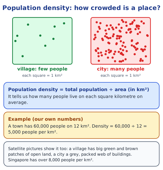
Five friends in your home have room to move; thirty people in the same room feel squeezed. Demographers, people who study populations, measure this crowding as population density: the number of people living on each square kilometre. It is found by dividing the total population of a region by its area in km². Satellite pictures of a village and of Gurugram city in Haryana show the difference at a glance: open green and brown fields in one, a packed grey web of buildings in the other.
What is urbanisation?
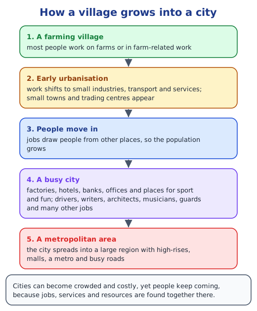
Urbanisation is the shift of people from rural to urban areas, so that a smaller share of the population lives in villages. A farming village first gains small industries, transport and services and becomes a small town or trading centre; jobs draw people in; new factories, banks, hotels and offices follow; and in time the city spreads into a large metropolitan area. In India, the share of people living in urban areas grew from 17 per cent in 1951 to about 40 per cent in 2025. Worldwide, 55 per cent of people live in cities now, and the United Nations expects 68 per cent by 2050. Read what is urbanisation?.
How do cities become centres of work?
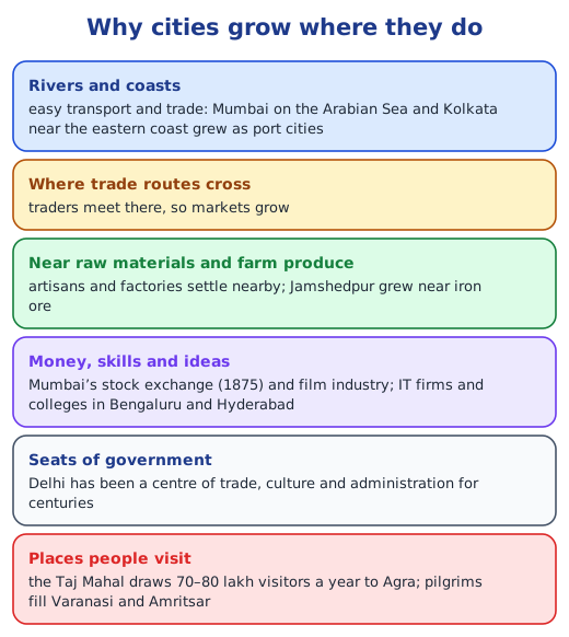
Places grow into cities because of where they are. Rivers and coasts make transport and trade easy, crossing trade routes give rise to markets, and nearby farm produce and raw materials attract artisans and factories. Sakchi, a village near iron ore, became the steel city of Jamshedpur. Mumbai, a port, became India’s financial capital after the Bombay Stock Exchange opened in 1875; Bengaluru and Hyderabad grew into hubs of technology; and smaller cities specialise, such as Moradabad in brass and Kanchipuram in silk sarees. Agra, Varanasi and Amritsar live on visitors, and Delhi grew into the National Capital Region. Read cities as economic and cultural hubs.
Cities as cultural hubs
People who move to a city bring their languages, food, customs and festivals, and the city mixes them. Mumbai’s vada pav, a potato vada inside a bread roll, became the quick meal of mill workers. Kolkata still has the Indian Museum and the Victoria Memorial from its years as the capital of British India, and every autumn it celebrates a five-day Durga Puja, which UNESCO added to its list of Intangible Cultural Heritage in 2021. Museums, libraries, stadiums and festivals give city people new experiences and help them build friendships and networks.
What challenges do cities face?
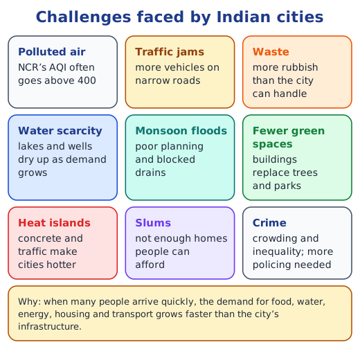
When many people arrive quickly, the demand for food, water, energy, housing and transport grows faster than the city can cope. Roads jam, unplanned colonies come up without water or drains, waste piles up, and concrete creates hot ‘heat islands’. The National Capital Region often records an Air Quality Index above 400, while the chapter gives 50 as the safe limit. Slums grow because there are not enough affordable homes. Bengaluru, once a city of about 1,000 lakes, has about 200 left, and faces both water shortages and floods. Read challenges and planning of cities.
How can planning help?
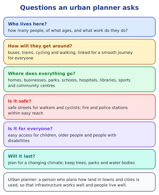
Urban planners ask how many people live in a place, what work they do, how they travel, where homes, parks, schools and hospitals should go, and how to keep streets safe. Jaipur, planned in 1727 by Vidyadhar Bhattacharya for Maharaja Sawai Jai Singh II, used a grid of blocks, wide streets, public squares and pink sandstone. Singapore, with over 8,000 people per km², plans land use up to 40 years ahead and updates its Master Plan every 5 years. In India, Ahmedabad’s Sabarmati Riverfront and Gangtok’s pedestrian-only M.G. Road show what good public spaces look like.
Before we move on
Cities are large settlements that gather work, culture and people. Location, business clusters, tourism and good infrastructure make them grow; growth then brings pollution, slums, traffic, waste and a loss of green spaces. With planning that keeps changing as people’s needs change, and care for Nature, cities can stay centres of new ideas, culture and prosperity. Answers to every question are in the NCERT solutions for Part 2 Chapter 7.
Key terms
| Term | Meaning |
|---|---|
| Urban area | A town or city with many people, many kinds of work, government offices and large transport networks, run by an elected urban local body. |
| Rural area | A village area with fewer people, close-knit communities and mostly farm-based work, run by a gram panchayat. |
| Population density | The number of people living on each square kilometre: total population ÷ area in km². |
| Demographer | A person who studies populations: their size, age structure, where people live and so on. |
| Satellite view | A picture of the Earth’s surface taken from above by a satellite going round the Earth. |
| Urbanisation | The shift of people from villages to towns and cities, so that a smaller share of people lives in rural areas. |
| Metropolitan area | A large city together with the built-up region that has grown around it. |
| Business Process Outsourcing (BPO) | When a company hires another firm to do some of its work, to save costs or to get expert help. |
| Air Quality Index (AQI) | One number that sums up how polluted the air is; the higher it is, the greater the risk to health. |
| Heat island | A built-up part of a city that stays hotter than the land around it, because of concrete, roads and traffic. |
| Slum | An overcrowded settlement with poor housing and little water, sanitation or other city services. |
| Urban planner | A person who plans how land in towns and cities is used, so that infrastructure and daily life work well. |
| Master Plan | A long-term plan that sets out how a city should grow and develop. |
| Vertical garden | Plants grown on walls, fences or other upright surfaces instead of on the ground. |
| Blue zone | A place where people live much longer, healthier lives than usual, often to 90 or 100, with less heart disease or diabetes. |
Topics in this chapter
Practice
-
In India, a place counts as urban when its population is more than:
Show answer
Answer: (b) 5,000
-
Population density tells us the number of:
Show answer
Answer: (b) people per square kilometre
-
Which city grew from the village of Sakchi?
Show answer
Answer: (c) Jamshedpur
-
Which city is called the Silicon Valley of India?
Show answer
Answer: (b) Bengaluru
-
Who was the chief planner of Jaipur?
Show answer
Answer: (b) Vidyadhar Bhattacharya
-
Singapore updates its Master Plan every:
Show answer
Answer: (b) 5 years
Questions students ask
What are the main topics of Class 8 Social Science Part 2 Chapter 7?
Urban and rural areas; population density; urbanisation and how a village grows into a city; why cities such as Jamshedpur, Mumbai, Bengaluru and Delhi grew; cities as cultural hubs; the challenges cities face, from traffic and polluted air to slums and water shortage; and how planning, as in Jaipur and Singapore, can improve city life.
Is India’s Urban Landscape in the new NCERT Class 8 Social Science book?
Yes. It is Chapter 7 of Exploring Society: India and Beyond, Grade 8 Part 2, in the theme Economic Life Around Us, on pages 191 to 214.
What is the difference between urban and rural areas?
Urban areas are towns and cities with many people, many kinds of work, big transport networks and elected urban local bodies. Rural areas are villages with fewer people, close-knit communities and mostly farm-based work, run by gram panchayats.
Why do cities need planning?
Because a city’s needs keep changing as more people arrive. Planning decides where homes, jobs, parks and services go and how people travel, so that the city stays safe, healthy and pleasant without using up its resources.
Stuck on a question?
Take a photo and Lagnever AI explains it step by step. Try it for 7 days for ₹2.
Get it on Google Play Open in browser
For parents: after the trial, the plan renews monthly by UPI or card autopay. You can cancel anytime in the app.