
NCERT Solutions Class 6 Social Science Chapter 2: Oceans and Continents
Answers to the Big Questions, every Let’s Explore and Think About It box and the “Questions, activities and projects” of Chapter 2, Oceans and Continents, in Exploring Society: India and Beyond. Some tasks are activities, so the answers below are models and methods: use them to prepare, then add your own work. Short notes: Chapter 2 notes.
The Big Questions (page 27)
1. What are oceans and continents? What are their names and their distribution?
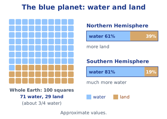
Oceans are the largest water bodies on the Earth, and continents are large continuous expanses of land. Water covers almost three-fourths of the surface and land a little over one-fourth. There are five oceans, the Pacific, Atlantic, Indian, Southern and Arctic, all connected. Continents are most often counted as seven: Asia, Africa, North America, South America, Antarctica, Europe and Australia. They are not spread evenly: the Northern Hemisphere has more land, and the Southern Hemisphere much more water.
2. In what ways do oceans and continents impact life on Earth, including human life?
They shape the climate. Oceans send rain to the continents, like India’s monsoon; their plants make more than half of the world’s oxygen; and they are home to countless marine plants and animals. People have used the seas for migration, trade, military campaigns and fishing, and coastal cultures have rich sea legends. Oceans also bring dangers such as cyclones and tsunamis. In turn, human activity harms the oceans through plastic, other pollution and overfishing.
In-text questions (pages 28 and 33)
The most widespread colour on the globe is blue, which represents water; the Earth is mostly covered with water. The white shapes in the picture of the Earth are large masses of clouds, which bring rain to the continents.
Let’s Explore: the polar maps (page 29)
- The circular lines around each pole are parallels of latitude, and the lines radiating out of the poles are meridians of longitude, seen from above the poles.
- The Southern Hemisphere holds more water.
- Proportions: the Northern Hemisphere is roughly 3 parts water to 2 parts land, and the Southern Hemisphere roughly 4 parts water to 1 part land. (Extra: about 61 per cent and 81 per cent water.)
- Are the oceans connected? Yes. They form one connected body of water; the separations between them are only lines drawn by convention.
Think About It: water scarcity (page 31)
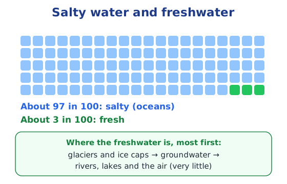
Why is there talk of water scarcity when there is so much water? Almost all of it is salty seawater that we cannot drink or use for farming. Freshwater is a very small part, and much of it is locked in glaciers or deep underground. What is left in rivers, lakes and groundwater is unevenly spread, often polluted, and used up fast by growing towns, farms and industries.
Ways of saving water: closing taps while brushing, fixing leaking taps and pipes, using a bucket instead of a shower or hose, reusing water (for example, water used for washing vegetables, for plants), collecting rainwater (rainwater harvesting), and drip irrigation on farms. Answers will vary with what you have seen at home, at school and in your village, town or city.
Let’s Explore: oceans and hemispheres (page 32)
| Ocean | Northern Hemisphere | Southern Hemisphere |
|---|---|---|
| Pacific Ocean | ✓ | ✓ |
| Atlantic Ocean | ✓ | ✓ |
| Indian Ocean | ✓ (a smaller part) | ✓ (most of it) |
| Southern Ocean | ✓ | |
| Arctic Ocean | ✓ |
Let’s Explore: the continents diagram (page 36)
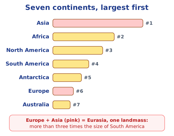
- Largest: Asia. Smallest: Australia.
- North America or South America? North America is larger. Africa or North America? Africa. Antarctica or Australia? Antarctica.
- Eurasia: colouring Europe and Asia together gives Eurasia, more than three times the size of South America.
- From the smallest to the largest: Australia, Europe, Antarctica, South America, North America, Africa, Asia.
Questions, activities and projects (pages 39–40)
1. Explain the following terms
- (a) Continent: a large, continuous expanse of land on the Earth, such as Asia or Africa. Most often seven continents are counted.
- (b) Ocean: one of the largest water bodies on the Earth, holding salty water. There are five, all connected: the Pacific, Atlantic, Indian, Southern and Arctic.
- (c) Island: a piece of land smaller than a continent, surrounded by water on all sides, such as Greenland or the Andaman Islands.
2. Draw the continents freehand
Without looking at a map, draw seven rough shapes in roughly the right places: the Americas on the left (North America above, South America below), Europe and Africa in the middle, Asia to the upper right, Australia to the lower right and Antarctica along the bottom. Colour each one, then compare with the map in the book. Notice where your shapes or sizes differ, for example whether you drew Asia large enough or Africa reaching far enough south.
3. Label the continents and oceans on the outline map
Label the seven continents and the five oceans in these positions:
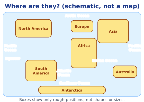
- Pacific Ocean: the largest, west of the Americas and east of Asia and Australia (it appears at both edges of a world map).
- Atlantic Ocean: between the Americas on one side and Europe and Africa on the other.
- Indian Ocean: south of Asia, between Africa and Australia.
- Arctic Ocean: around the North Pole, at the top.
- Southern Ocean: around Antarctica, at the bottom.
4. The crossword
Across
| Clue | Answer |
|---|---|
| 1. Abundantly produced by the oceans | OXYGEN |
| 3. A large expanse of landmass | CONTINENT |
| 6. A large continent of which India is a part | EURASIA |
| 8. A major source of pollution of the oceans | PLASTIC |
| 10. The coldest continent | ANTARCTICA |
Down
| Clue | Answer |
|---|---|
| 2. The largest island on Earth | GREENLAND |
| 4. A huge destructive wave from the ocean | TSUNAMI |
| 5. The smallest continent | AUSTRALIA |
| 7. The largest body of water on the Earth | PACIFIC |
| 9. A landmass (but not a continent) surrounded by the sea or ocean | ISLAND |
6 Across has seven squares, so the answer is EURASIA rather than ASIA; its letters fit the crossing words GREENLAND, TSUNAMI and AUSTRALIA.
For more practice, read oceans of the world and continents of the world.
Practice
-
Which is the second largest ocean?
Show answer
Answer: (b) Atlantic
-
India set up its first base in Antarctica, Dakshin Gangotri, in:
Show answer
Answer: (c) 1983
-
World Oceans Day is observed on:
Show answer
Answer: (c) 8 June
-
Why are the oceans called ‘the planet's lungs’?
Show answer
Answer: Because more than half of the world's oxygen is produced by the plants of the oceans.
-
Name India's two major island groups and the seas they lie in.
Show answer
Answer: The Andaman and Nicobar Islands in the Bay of Bengal and the Lakshadweep Islands in the Arabian Sea.
Stuck on a question?
Take a photo and Lagnever AI explains it step by step. Try it for 7 days for ₹2.
Get it on Google Play Open in browser
For parents: after the trial, the plan renews monthly by UPI or card autopay. You can cancel anytime in the app.