
India’s land neighbours
Answer in short
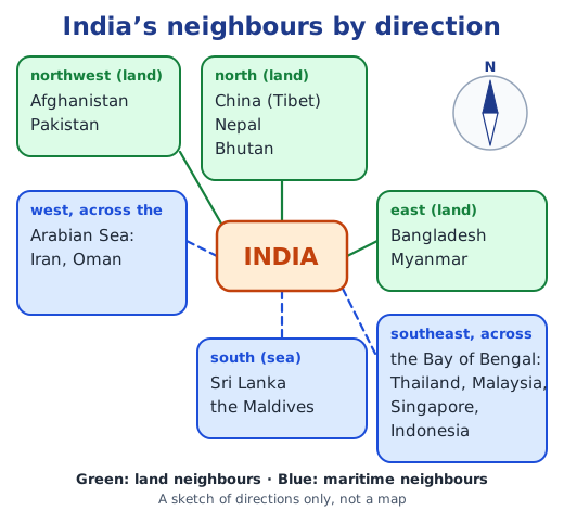
India has seven land neighbours: Pakistan and Afghanistan lie to the northwest; Tibet (a region of China), Nepal and Bhutan to the north; and Bangladesh and Myanmar to the east. The land boundary runs for over 15,100 km. History, rivers, Buddhism and trade link these neighbours to India, in friendship and in tension.
Stuck on a question? Take a photo and Lagnever AI explains it step by step. Try it for 7 days for ₹2. Get it on Google Play
Neighbours on land
India’s land boundary is over 15,100 km long and crosses deserts and plains, forests and mountains, marshes and river valleys. Seven neighbours lie along it: to the northwest Pakistan and Afghanistan, to the north Tibet (a region of China), Nepal and Bhutan, and to the east Bangladesh and Myanmar.
China
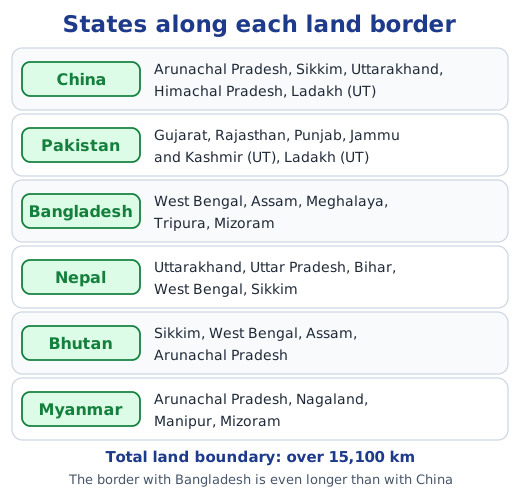
China, about three times larger than India, is our largest neighbour. The Himalayas separate them, and the border runs along Arunachal Pradesh, Sikkim, Uttarakhand, Himachal Pradesh and Ladakh. Buddhism reached China from India around the 1st century CE, carried along trade and pilgrim routes; Faxian and Xuanzang came to study in India, and Bodhidharma, Dharmakṣhema and Kumārajīva taught in China. By the 13th century, Hindu merchants had built temples in the Chinese port of Quanzhou. Today India sells China iron ore, chemicals and cotton yarn, and buys electronics and machinery, but China’s sales to India are about eight times larger. Border tensions have flared at times, while dialogue and trade continue.
Pakistan and Afghanistan
Pakistan was part of India until the Partition of 1947. Wars in 1948, 1965 and 1971, the Kargil War of 1999 and frequent terrorist attacks backed by the Pakistan army have kept relations tense. The border runs along Gujarat, Rajasthan, Punjab, Jammu and Kashmir and Ladakh. Still, shared heritage survives: the Katas Raj temples, the Hinglaj Mata Mandir, and the Kartarpur Corridor, opened in 2019 so that Indian pilgrims can visit Guru Nānak’s resting place with a permit instead of a visa. Afghanistan, a landlocked country, was linked to India by the ancient Uttarāpatha route; it was once a centre of Buddhist and Hindu culture, as the Bamiyan Buddhas showed until their destruction in 2001. India has built its Parliament building and the Zaranj–Delaram highway.
Bangladesh
Bangladesh, earlier East Pakistan, was born in 1971 after a war between India and Pakistan. It shares the Bangla language with West Bengal, and its border with India, longer even than the one with China, runs along West Bengal, Assam, Meghalaya, Tripura and Mizoram. Rivers of the Ganga and Brahmaputra systems support farming, fishing and transport in both countries, and the two protect the Sundarban, the world’s largest mangrove forest and a shield against cyclones, together.
Nepal and Bhutan
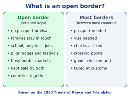
Nepal’s border with India runs from Uttarakhand in the west, past Uttar Pradesh, Bihar and West Bengal, to Sikkim. Under the 1950 Treaty of Peace and Friendship it is an open border: people cross without passports or visas for school, hospitals, jobs, trade and family visits. Pilgrims visit the Paśhupatinātha temple in Kathmandu, festivals such as Holi are shared, and India is Nepal’s largest trading partner.
Bhutan, the ‘Land of the Thunder Dragon’, touches Sikkim, West Bengal, Assam and Arunachal Pradesh. Guru Padmasambhava took Vajrayāna Buddhism there in the 8th century, and Bhutanese pilgrims visit Bodh Gaya, Rajgir and Nalanda. Rivers from Bhutan run hydroelectric plants, such as the Tala project, that power both countries. Bhutan measures progress by Gross National Happiness.
Myanmar
Myanmar borders Arunachal Pradesh, Nagaland, Manipur and Mizoram and also shares a sea boundary in the Bay of Bengal. A 2018 agreement eased crossings for border people, though conflict has since brought some limits. India helped restore the Ananda temple at Bagan, and the Trilateral Highway will link Manipur through Myanmar to Thailand.
Why it matters
Knowing who our land neighbours are, and what links and divides us, helps us understand news, trade and travel. Continue with India’s maritime neighbours. Answers to the textbook questions are in the NCERT solutions for Part 2 Chapter 2; see all of Part 2 Chapter 2 notes.
Practice
-
Which neighbour is called the ‘Land of the Thunder Dragon’?
Show answer
Answer: (b) Bhutan
-
Which Indian states border Nepal?
Show answer
Answer: (b) Sikkim, West Bengal, Bihar, Uttar Pradesh and Uttarakhand
-
The Kartarpur Corridor lets Indian pilgrims visit a gurdwara in:
Show answer
Answer: (c) Pakistan
-
Name two ways in which India and Bangladesh are linked.
Show answer
Answer: They share a common history and the Bangla language, which is also spoken in West Bengal. They also share rivers of the Ganga and Brahmaputra systems and the Sundarban mangrove forest, which they protect together.
-
Why is Myanmar called India’s gateway to Southeast Asia?
Show answer
Answer: It shares a land border with India’s northeast and a sea boundary in the Bay of Bengal, so roads, trade and people from India can reach Southeast Asia through it, for example along the India–Myanmar–Thailand Trilateral Highway.
Questions students ask
Which are India’s land neighbours?
To the northwest, Pakistan and Afghanistan; to the north, Tibet (a region of China), Nepal and Bhutan; and to the east, Bangladesh and Myanmar.
What is an open border?
An open border is one that the people of the two countries can cross without a passport or visa. The India–Nepal border is open under the 1950 Treaty of Peace and Friendship, so people cross for work, study, health care, trade and family.
Which Indian states border China?
From west to east along the Himalayas: Ladakh (a Union Territory), Himachal Pradesh, Uttarakhand, Sikkim and Arunachal Pradesh.
Stuck on a question?
Take a photo and Lagnever AI explains it step by step. Try it for 7 days for ₹2.
Get it on Google Play Open in browser
For parents: after the trial, the plan renews monthly by UPI or card autopay. You can cancel anytime in the app.