
What are the components of a map?
Answer in short
A map has three main components: distance, direction and symbols. Distance is shown by the scale, such as 1 cm = 500 m, which links the map to the ground. Direction uses north, east, south and west and the four directions between them. Symbols are small signs for features like roads, rivers and buildings.
Stuck on a question? Take a photo and Lagnever AI explains it step by step. Try it for 7 days for ₹2. Get it on Google Play
What is a map?
A map is a representation, or drawing, of an area as if you were looking at it from the top. It may show a small area like a village or town, a bigger one like a district or State, or a very large one like India or the whole world. An atlas is a book or collection of maps.
Maps are of several kinds. Physical maps mainly show natural features such as mountains, oceans and rivers. Political maps show countries or States, boundaries, cities and capitals, like a map of India with all its States and Union Territories. Thematic maps show one specific kind of information.
Whatever its kind, a map is useful because of three components: distance, direction and symbols.
Distance: the scale
How can a whole city fit on a small sheet of paper? Thanks to the map’s scale. Each centimetre on the map stands for a fixed distance on the ground. If one centimetre stands for 500 metres, we write the scale as 1 cm = 500 m.
Some maps show the scale as a small ruler, called a scale bar. On the map of India in Chapter 5 of the textbook, a ruler 2.5 cm long stands for 500 km. That means 1 cm stands for 200 km.
To find a real distance:
- Measure the distance on the map with a ruler, in centimetres.
- Multiply by the distance that 1 cm stands for.
For example, if two towns are 3 cm apart on a map with 1 cm = 200 km, they are 3 × 200 = 600 km apart on the ground.
You can also go the other way and draw something to scale. The textbook asks you to draw a school playground 40 m long and 30 m wide on the scale 1 cm = 10 m.
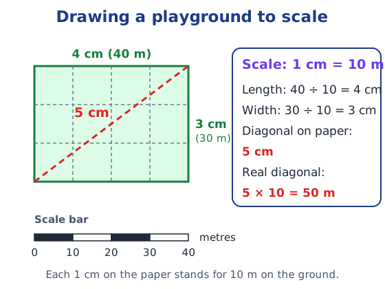
Divide each length by 10: the playground becomes a rectangle 4 cm by 3 cm. Measure its diagonal and you get 5 cm, so the real diagonal is 5 × 10 = 50 m.
Direction
Most maps have north at the top. Moving clockwise from north, we have east, south and west. These four are the cardinal directions, also called cardinal points. Halfway between them are the intermediate directions: northeast (NE), southeast (SE), southwest (SW) and northwest (NW).
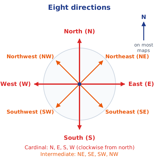
Many maps do not draw all eight. They simply show an arrow marked N, pointing north. Once you know where north is, you can work out every other direction: turn the map so that the arrow points away from you, and east is on your right.
Practise with the town map below. Stand at the chowk in the middle and name the direction of each place.
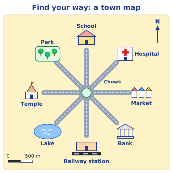
From the chowk, the school is to the north and the railway station to the south. The market is east and the temple west. The hospital is northeast, the bank southeast, the lake southwest and the park northwest. You can also compare two places: the market is east of the temple, and the park is northwest of the bank.
Symbols
The textbook’s city map has small drawings of buildings, but on the map of a large city or a whole country there is no space to draw them all. Instead, symbols are used: small signs for buildings like a railway station, a school or a post office, for roads and railway lines, and for natural features such as a river, a pond or a forest. In that way many details fit into the limited space.
Different countries use different sets of symbols. In India, the Survey of India, a government body, has fixed a standard set for maps of India, so that every user reads them the same way.
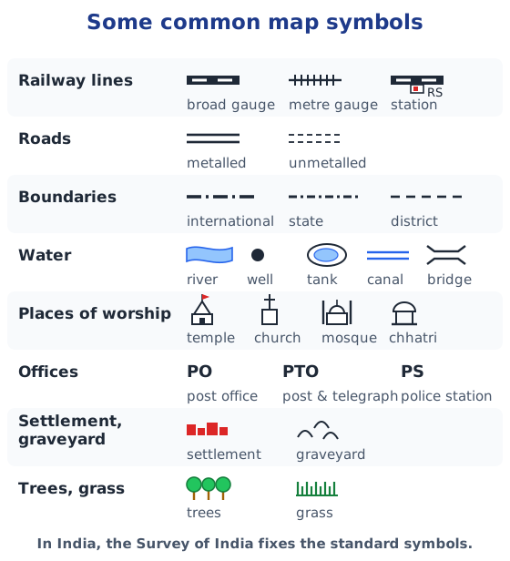
Colours help too. On most maps, blue shows water such as rivers, lakes and the sea, and green often shows trees or low land.
Try it yourself
Draw a rough map of your locality or village. Mark your home, your school and a few landmarks such as a shop, a temple or a pond. Add an arrow marked N, use some of the symbols above, and note roughly in which direction your home lies from your school. For all the textbook questions on maps, see the Chapter 1 NCERT solutions, and for the rest of the chapter the Chapter 1 notes.
Practice
-
Which of these is an intermediate direction?
Show answer
Answer: (c) Southeast
-
On the town map on this page, which place is to the northeast of the chowk?
Show answer
Answer: (b) Hospital
-
On a map with the scale 1 cm = 200 km, two towns are 3 cm apart. How far apart are they on the ground?
Show answer
Answer: 3 × 200 km = 600 km.
-
On the town map, in which direction is the railway station from the school?
Show answer
Answer: South. The school is north of the chowk and the railway station is south of it.
-
Why do maps use symbols instead of drawings of every building?
Show answer
Answer: There is not enough space on the map of a large city or country to draw everything. Small standard symbols show many features in little space, and everyone can read them the same way.
Questions students ask
What are the three components of a map?
Distance, direction and symbols. Distance is shown with a scale, direction with the cardinal and intermediate directions (often just an arrow marked N), and features such as roads, rivers and buildings with symbols.
What is the scale of a map?
It tells how a distance on the map stands for a distance on the ground. On the scale 1 cm = 500 m, every centimetre on the map means 500 metres in reality, so a 3 cm line means 1,500 m.
What are cardinal and intermediate directions?
The cardinal directions are north, east, south and west, in clockwise order from north. The intermediate directions lie between them: northeast, southeast, southwest and northwest.
Who decides the symbols used on maps of India?
The Survey of India, a government body. It has fixed a standard set of symbols for maps of India, such as those for railway lines, metalled roads, wells, post offices and police stations.
Stuck on a question?
Take a photo and Lagnever AI explains it step by step. Try it for 7 days for ₹2.
Get it on Google Play Open in browser
For parents: after the trial, the plan renews monthly by UPI or card autopay. You can cancel anytime in the app.