
NCERT Solutions Class 6 Social Science Chapter 1: Locating Places on the Earth
Answers to the Big Questions, every Let’s Explore box and the “Questions, activities and projects” of Chapter 1, Locating Places on the Earth, in Exploring Society: India and Beyond. Some questions are activities, so the answers below are models and methods: use them to prepare, then add your own observations. Short notes: Chapter 1 notes.
The Big Questions (page 7)
1. What is a map and how do we use it? What are its main components?
A map is a drawing of an area, small or large, as if seen from the top. We use maps to find places and plan how to reach them, and to learn about an area: its natural features (physical maps), its boundaries and cities (political maps) or one kind of information (thematic maps). Its three main components are distance (shown by the scale, such as 1 cm = 500 m), direction (north, east, south, west and the intermediate directions) and symbols (standard signs for roads, railways, rivers, buildings and so on).
2. What are coordinates? How can latitude and longitude be used to mark any location on the Earth?
Coordinates are two values that fix a position, like “the 7th shop in the 5th row” in a market or d4 on a chessboard. On the Earth, the two coordinates are latitude, the distance north or south of the Equator (0° to 90°), and longitude, the distance east or west of the Prime Meridian at Greenwich (0° to 180°). The parallels and meridians form a grid on the globe, so every place has its own pair of values: Delhi, for example, lies at about 29°N, 77°E.
3. How are local time and standard time related to longitude?
The Earth turns 360° in 24 hours, 15° every hour, so local time changes by 4 minutes for each degree of longitude; places to the east are ahead. Standard time is one time chosen for a whole country, the local time of a meridian passing through it. India’s standard time, IST, is the local time of 82°30′E, 5 hours 30 minutes ahead of GMT.
Let’s Explore: the map of a small city (page 9)
1. Mark the hospital. On Fig. 1.1, the hospital is the pink building with a red cross, in the middle-left of the map, between the lake and the market.
2. What is the meaning of the blue-coloured areas? Water: a stream that flows down into the lake. On maps, blue is used for water bodies such as rivers, lakes, ponds and the sea.
3. Which is farther away from the railway station: the school, the Nagar Panchayat or the public garden? The public garden, in the top-right corner of the map. The school is the closest of the three, and the Nagar Panchayat, in the middle of the map, comes next.
Group activity: a map of your school. Draw the school building and playground, the roads or streets leading to it and a few neighbouring buildings. Agree on where north is and add an arrow marked N, keep sizes roughly in proportion, and use simple symbols. When the groups compare maps, notice what each group chose to show and what it left out.
Let’s Explore: a playground to scale (page 10)
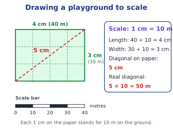
On the scale 1 cm = 10 m, the 40 m × 30 m playground becomes a rectangle 4 cm × 3 cm. Its diagonal measures 5 cm, so the real diagonal is 5 × 10 = 50 m.
Let’s Explore: directions on the city map (page 11)
Remember that north is at the top of the map, east on the right, south at the bottom and west on the left.
| Statement | Correct or incorrect? | Why |
|---|---|---|
| 1. The market is north of the hospital. | Incorrect | The market is below the hospital, so it is south of it. |
| 2. The museum is southeast of the bank. | Correct | The museum is below the bank and a little to its right (almost due south). |
| 3. The railway station is northwest of the hospital. | Correct | The station is to the left of the hospital and a little above it. |
| 4. The lake is northwest of the apartment blocks. | Incorrect | The lake is to the left of and below the apartments, so it is southwest of them. |
In which direction is your home from your school? Answers will vary. Stand at the school gate facing the rising sun: that is roughly east, with north on your left. Then decide which way your home lies, for example “my home is to the northeast of my school”.
Let’s Explore: a rough map of your locality (page 11)
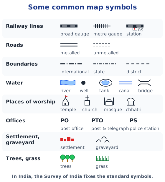
Draw your home, your school and a few landmarks such as a market, a temple, a pond or a bus stop. Show the cardinal directions with an arrow marked N and use symbols from Fig. 1.2, for example two solid lines for a metalled road, a black dot for a well and PO for a post office.
Let’s Explore: the chess move (page 13)
If you play black and reply with the same move, your queen’s pawn also moves two squares forward: from d7 to d5.
Let’s Explore: four cities on the grid (page 17)
Approximate values from a globe or atlas:
| City | Latitude | Longitude |
|---|---|---|
| Mumbai | about 19°N | about 73°E |
| Kolkata | about 22.5°N | about 88°E |
| Singapore | about 1°N | about 104°E |
| Paris | about 49°N | about 2°E |
Let’s Explore: the two friends (page 21)
Why is it dark in Assam but still daylight in Gujarat? The Earth spins from west to east, so the sun rises and sets earlier in places farther east. Tinsukia, in Assam, is far to the east of Porbandar, in Gujarat, so the sun sets there much earlier.
Difference in local time. Taking the difference in longitude as 30°: 30 × 4 minutes = 120 minutes, so Tinsukia’s local time is 2 hours ahead of Porbandar’s. (Extra: the precise longitudes, about 95.4°E and 69.6°E, are nearly 26° apart, which gives about 1 hour 43 minutes.)
Local time and standard time. Both friends’ watches show the same time, because all of India follows IST. But their local, or sun, times differ by about 2 hours: when the watches show 5:30 pm, it is already evening by the sun in Tinsukia and still afternoon in Porbandar. Local time follows each place’s longitude; standard time is one shared time for the whole country.
Questions, activities and projects (pages 24–25)
1. Using the scale 2.5 cm = 500 km on Fig. 5.2, calculate the real distance from the estuary of the Narmada to the estuary of the Ganga.
First simplify the scale: 2.5 cm = 500 km means 1 cm = 200 km. Measure the straight line on the map from the mouth of the Narmada (on the Gulf of Khambhat, west coast) to the mouth of the Ganga (Bay of Bengal, east coast) and round it off. If you measure about 8 cm, the real distance is 8 × 200 = about 1,600 km. Your answer may differ a little with your measurement.
2. Why is it 5:30 pm in India when it is 12 pm or noon in London?
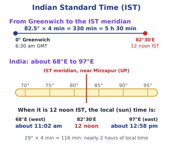
London is on the Prime Meridian (0°), and Indian Standard Time is based on the meridian at 82°30′E. The Earth spins from west to east, so places to the east have a later time, 4 minutes for each degree: 82.5 × 4 = 330 minutes, or 5 hours 30 minutes. So when it is 12 noon in London (GMT), it is 5:30 pm in India. (Extra: from late March to late October the UK moves its clocks one hour ahead, and the gap is then 4 hours 30 minutes.)
3. Why do we need symbols and colours in the map?
There is not enough space on a map to draw every building, road or river. Small symbols show many features in little space, and because the Survey of India fixes standard symbols, everyone reads them the same way. Colours make features easy to tell apart at a glance: blue for water, for example, and green for trees or low land.
4. Find out what you have in the eight directions from your home or school.
Answers will vary. Find north first (with a compass app, or face the rising sun: north is on your left), then note one feature in each direction, for example: North, a temple; Northeast, a park; East, the main road; Southeast, a shop; South, a pond; Southwest, a bus stop; West, a field; Northwest, a hospital.
5. What is the difference between local time and standard time? Answer in 100 to 150 words.
A model answer: Local time is the time at a place according to the position of the Sun, so it depends on the place’s longitude. The Earth turns 360° in 24 hours, or 15° each hour, so local time changes by 4 minutes for every degree of longitude: places to the east are ahead and places to the west are behind. If every town kept its own local time, clocks in Porbandar and Tinsukia would differ by almost two hours, and trains, offices and phone calls would be confusing. So a country chooses one standard time, the local time of a meridian passing through it, and all clocks follow it. India’s standard time, IST, is the local time of 82°30′E, 5 hours 30 minutes ahead of GMT. Local time differs from place to place; standard time is the same across the country.
6. Delhi’s and Bengaluru’s latitudes are 29°N and 13°N; their longitudes are almost the same, 77°E. How much will be the difference in local time between the two cities?
Almost none. Local time depends only on longitude, not latitude. Both cities are at about 77°E, so their local times are practically the same, even though Bengaluru is far to the south.
7. True or false? Explain each with a sentence or two.
| Statement | True or false | Explanation |
|---|---|---|
| All parallels of latitude have the same length. | False | The Equator is the longest; parallels get shorter towards the poles, where they shrink to a point. |
| The length of a meridian of longitude is half of that of the Equator. | True | A meridian is a half-circle from pole to pole, while the Equator is a full circle around the same globe. |
| The South Pole has a latitude of 90°S. | True | The poles are 90° from the Equator: 90°N and 90°S. |
| In Assam, the local time and the IST are identical. | False | Assam lies at about 90°E to 96°E, east of the IST meridian (82°30′E), so its local time is about half an hour to nearly an hour ahead of IST. |
| Lines separating the time zones are identical with meridians of longitude. | False | They broadly follow 15° bands but bend along international borders. |
| The Equator is also a parallel of latitude. | True | It is the 0° parallel, the longest one. |
8. Solve the crossword.
Across
| Clue | Answer |
|---|---|
| 1. Lets you squeeze a huge area into your map | SCALE |
| 4. A convenient sphere | GLOBE |
| 5. The longest parallel of latitude | EQUATOR |
| 6. The place the Prime Meridian is attached to | GREENWICH |
| 8. So convenient to find your way | MAP |
| 10. Distance from the Equator | LATITUDE |
Down
| Clue | Answer |
|---|---|
| 2. Distance from the Prime Meridian | LONGITUDE |
| 3. Together they locate a place | COORDINATES |
| 6. What latitudes and longitudes create | GRID |
| 7. The time we all follow in India | IST |
| 9. On top of the world | POLE |
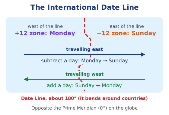
| 11. The line where the day and date change | IDL (International Date Line) |
For more practice, read components of a map, latitudes and longitudes and Indian Standard Time.
Practice
-
Who fixes the standard map symbols for maps of India?
Show answer
Answer: (a) The Survey of India
-
In which year was the meridian through Greenwich chosen as the Prime Meridian?
Show answer
Answer: (b) 1884
-
In which two hemispheres does India lie?
Show answer
Answer: (a) Northern and Eastern
-
If it is 9 am at Greenwich (GMT), what time is it in India (IST)?
Show answer
Answer: IST is 5 hours 30 minutes ahead of GMT, so it is 2:30 pm in India.
-
What is an atlas?
Show answer
Answer: A book or collection of maps.
Stuck on a question?
Take a photo and Lagnever AI explains it step by step. Try it for 7 days for ₹2.
Get it on Google Play Open in browser
For parents: after the trial, the plan renews monthly by UPI or card autopay. You can cancel anytime in the app.