
What are latitudes and longitudes?
Answer in short
Latitudes and longitudes are imaginary lines that form a grid on the globe. Latitude measures how far a place is north or south of the Equator, from 0° to 90°. Longitude measures how far it is east or west of the Prime Meridian at Greenwich, from 0° to 180°. Together they give every place two coordinates.
Stuck on a question? Take a photo and Lagnever AI explains it step by step. Try it for 7 days for ₹2. Get it on Google Play
Two values fix a place
Imagine telling a friend to meet you at “the 7th shop in the 5th row from the entrance” of a big market. Those two numbers let your friend find the exact shop. A chessboard works the same way: its columns are named a to h and its rows 1 to 8, so every square has a name. When White opens by moving the queen’s pawn two squares forward, we write that the pawn moved from d2 to d4.
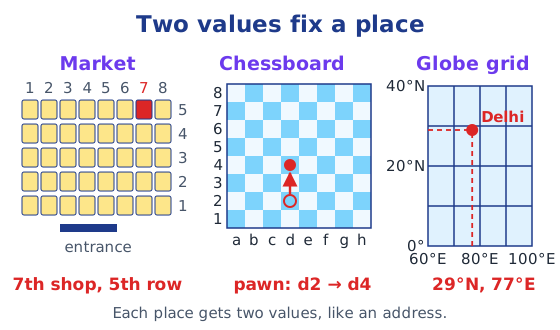
Such a system is called a system of coordinates. Maps use one too, made of two sets of imaginary lines on the globe: latitudes and longitudes.
Latitudes: distance from the Equator
Spin a globe: the two fixed points at the top and bottom are the North Pole and the South Pole. Halfway between them runs the Equator.
Walk from the Equator towards a pole and your distance from the Equator grows. Latitude measures this distance. At any point you can draw an imaginary line running east and west, parallel to the Equator. It is called a parallel of latitude and makes a circle around the Earth.
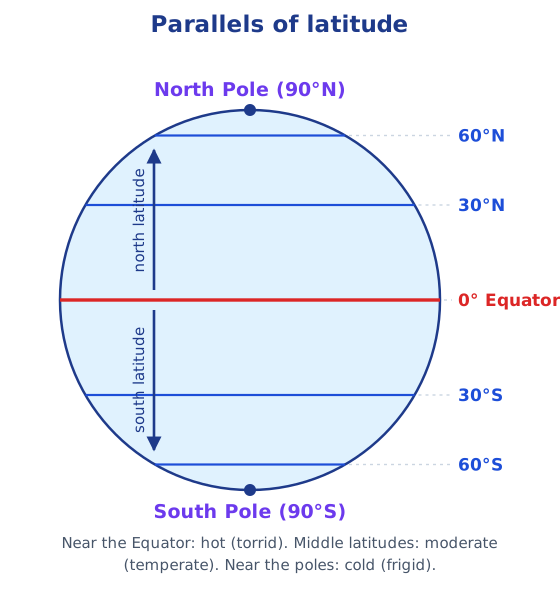
Latitude is measured in degrees. The Equator is 0°; the poles are 90°N and 90°S. The Equator is the largest circle, and the parallels grow smaller towards the poles.
Latitude is connected with climate. Near the Equator it is generally hot, or ‘torrid’. As latitude increases, the climate becomes moderate, or ‘temperate’, and near the poles it is cold, or ‘frigid’.
Longitudes: distance from the Prime Meridian
Now travel from the North Pole to the South Pole by the shortest path. You could pass through Europe and Africa, or through Asia; the distance is the same. These shortest pole-to-pole lines are meridians of longitude, all half-circles of equal length.
To measure longitude we need a starting line. In 1884, nations agreed that the meridian through Greenwich, an area of London, would be the Prime Meridian, marked 0°. Longitude is the distance east or west of it, measured along the Equator in degrees from 0° to 180°, with E or W added.
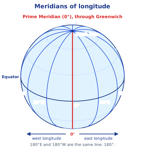
In round figures, New York is at 74°W, Delhi at 77°E and Tokyo at 140°E. Going east or west you finally reach the same meridian on the far side of the globe, so 180°E and 180°W are one line, written simply 180°.
The grid and coordinates
Latitude and longitude together are the two coordinates of a place. The parallels and meridians form a grid, so their lines are called grid lines. “Delhi lies at 29°N latitude and 77°E longitude” fixes Delhi on the Earth (the values are rounded). In the same way, Mumbai is at about 19°N, 73°E, Kolkata about 22.5°N, 88°E, Singapore about 1°N, 104°E and Paris about 49°N, 2°E.
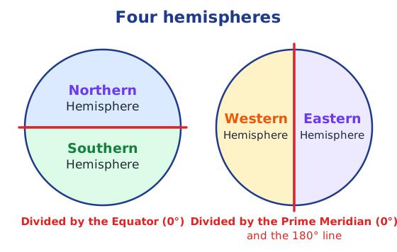
The Equator divides the Earth into the Northern and Southern Hemispheres. The Prime Meridian, with the 180° line opposite it, divides the Earth into the Western and Eastern Hemispheres. India lies in the Northern and Eastern Hemispheres.
India’s own prime meridian
Greenwich was not the first prime meridian. Many centuries before Europe, India had one of its own, the madhya rekhā or ‘middle line’. It passed through Ujjayinī (today Ujjain), a famous centre of astronomy where Varāhamihira lived and worked about 1,500 years ago. All Indian astronomical texts used it for their calculations.
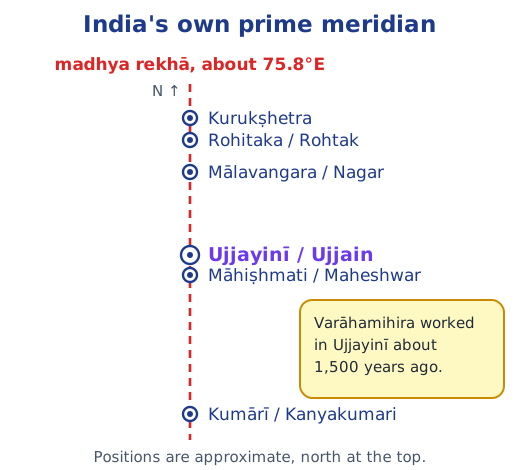
Some of the ancient cities named on this meridian lie a little off it, because measuring longitude needs accurate timekeeping, which was less precise then.
Latitude and longitude compared
| Latitude | Longitude | |
|---|---|---|
| Measured from | the Equator (0°) | the Prime Meridian (0°) |
| Goes up to | 90°N and 90°S | 180°E and 180°W |
| Its lines | parallels, running east–west | meridians, running pole to pole |
| Length of lines | shrink towards the poles | all equal half-circles |
India stretches from about 8°N to 37°N and from 68°E to 97°E. Its longitude also explains its time; see Indian Standard Time. For the whole chapter, see the Chapter 1 notes.
Practice
-
The longest parallel of latitude is:
Show answer
Answer: (b) the Equator
-
The latitude of the North Pole is:
Show answer
Answer: (b) 90°N
-
Through which city did ancient India's prime meridian, the madhya rekhā, pass?
Show answer
Answer: (a) Ujjayinī (Ujjain)
-
Delhi lies at about 29°N, 77°E. Which value is its latitude and which is its longitude?
Show answer
Answer: 29°N is the latitude (distance north of the Equator) and 77°E is the longitude (distance east of the Prime Meridian).
-
Why are 180°E and 180°W written simply as 180°?
Show answer
Answer: Going east or west from Greenwich, you reach the same meridian on the far side of the globe, so 180°E and 180°W are one line and need no letter.
Questions students ask
What is the difference between latitude and longitude?
Latitude tells how far north or south of the Equator a place is (0° to 90°N or S); its lines, the parallels, run east–west. Longitude tells how far east or west of the Prime Meridian a place is (0° to 180°E or W); its lines, the meridians, run from pole to pole.
Why is the Prime Meridian at Greenwich?
Any meridian could serve as the starting line, so one had to be chosen. In 1884, a group of nations agreed that the meridian through Greenwich, an area of London, would be the international standard, marked 0° longitude.
What was the madhya rekhā?
The ‘middle line’, India's own prime meridian, used many centuries before Greenwich. It passed through Ujjayinī (Ujjain), a centre of astronomy where Varāhamihira worked about 1,500 years ago, and Indian astronomical texts used it as their reference.
Are all meridians the same length?
Yes. Every meridian is a half-circle from the North Pole to the South Pole, so all are equal, and each is half as long as the Equator. Parallels of latitude are different: they get shorter towards the poles.
Stuck on a question?
Take a photo and Lagnever AI explains it step by step. Try it for 7 days for ₹2.
Get it on Google Play Open in browser
For parents: after the trial, the plan renews monthly by UPI or card autopay. You can cancel anytime in the app.