
Class 6 Social Science Chapter 1: Locating Places on the Earth Notes
This chapter in five lines
A map is a drawing of an area seen from above, and its three main components are distance, shown by the scale, direction and symbols. Because the Earth is nearly a sphere, a globe shows it more truly. A grid of latitudes, measured from the Equator, and longitudes, measured from the Prime Meridian at Greenwich, gives every place two coordinates. Longitude also sets local time: the Earth turns 15° an hour, and India follows one standard time, IST, 5 hours 30 minutes ahead of GMT.
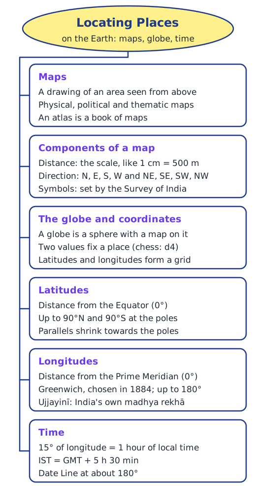
Why do we need maps?
The chapter opens with words of the astronomer Āryabhaṭa (about 500 CE), who described the Earth as a globe standing in space. Then it asks a practical question: if you visit a city for the first time, how do you find the places you want to see? You could ask someone, or you could look at a map. The book’s map of an imaginary small city lets you plan a route from the railway station to the bank, find the school, the public garden and the museum, and walk on from the bank to the market.
A map is a representation, or drawing, of an area as if you were looking at it from the top. The area can be small (a village or town), bigger (a district or State) or very large (India or the whole world). An atlas is a book or collection of maps. There are several kinds:
| Kind of map | What it mainly shows |
|---|---|
| Physical map | Natural features: mountains, oceans, rivers |
| Political map | Countries or States, boundaries, cities and capitals |
| Thematic map | One specific kind of information |
The three components of a map
Every map is built on three components: distance, direction and symbols. Read more in components of a map.
Distance and scale. A huge area fits on a small sheet thanks to the map’s scale. If each centimetre on the city map stands for 500 metres on the ground, the scale is 1 cm = 500 m. On the book’s map of India in Chapter 5, a small ruler 2.5 cm long stands for 500 km.
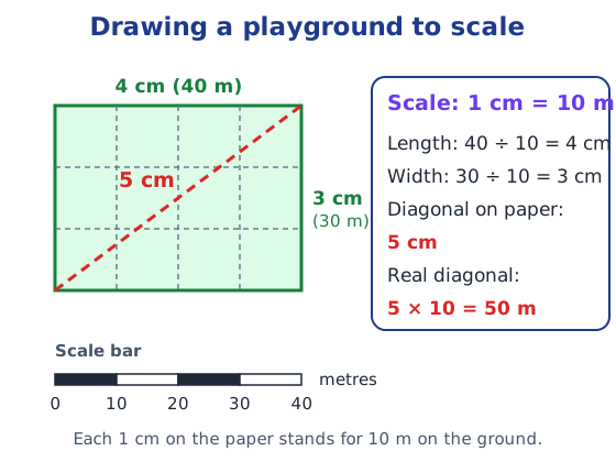
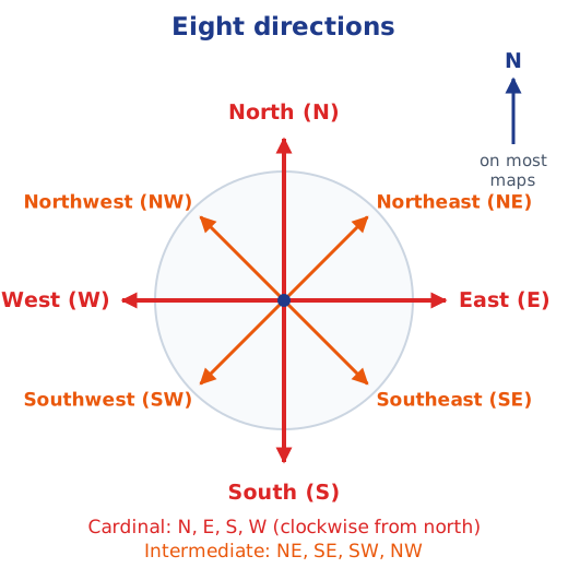
Direction. North is at the top of most maps; moving clockwise come east, south and west. These four are the cardinal directions. Between them lie the intermediate directions: northeast (NE), southeast (SE), southwest (SW) and northwest (NW). Most maps just show an arrow marked N.
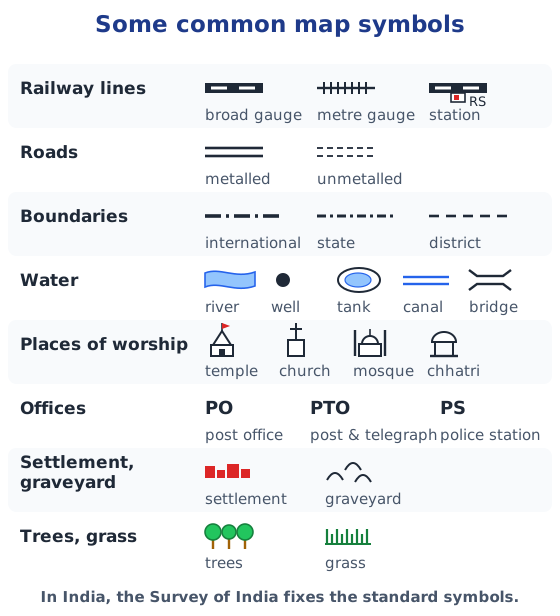
Symbols. There is no room to draw every building on the map of a large city or a country, so symbols stand for railway lines, roads, boundaries, rivers, wells, tanks, bridges, places of worship, post offices, police stations, trees and more. In India, the Survey of India, a government body, fixes a standard set of symbols so that everyone reads maps the same way.
Mapping the Earth: the globe
The Earth is not flat. It is nearly a sphere, slightly flattened at the poles. A sphere cannot be shown accurately on flat paper: try flattening three or four large pieces of orange peel on a table and they tear at the edges. A globe is a sphere on which a map is drawn, so it shows the Earth’s shape truly.
Coordinates: latitude and longitude
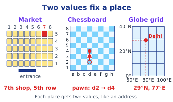
To tell a friend where to meet in a market with neat rows of shops, you might say “the 7th shop in the 5th row from the entrance”. A chessboard works the same way: columns a to h and rows 1 to 8 name every square, so a pawn moving from d2 to d4 is recorded exactly. Two values that fix a place are called coordinates. On the Earth, they are latitude and longitude.
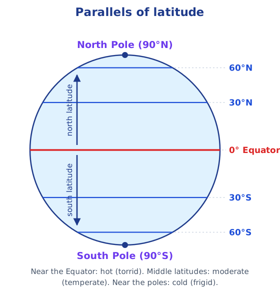
Latitudes. The Equator circles the globe halfway between the North and South Poles. Latitude measures how far a place is from the Equator: 0° at the Equator, up to 90°N and 90°S at the poles. An east–west line through any point is a parallel of latitude; the Equator is the longest, and the parallels get smaller towards the poles. Latitude is linked to climate: hot (torrid) near the Equator, moderate (temperate) farther away, and cold (frigid) near the poles.
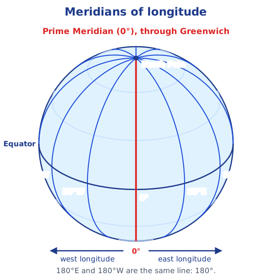
Longitudes. Meridians of longitude are half-circles from pole to pole. In 1884, nations chose the meridian through Greenwich, in London, as the Prime Meridian (0°). Longitude measures distance east or west of it, from 0° to 180°E or 180°W. In round figures, New York is at 74°W, Delhi at 77°E and Tokyo at 140°E. Because 180°E and 180°W are the same line, it is written simply as 180°.
Together, parallels and meridians form a grid, and any place can be located by its two coordinates: Delhi lies at about 29°N latitude and 77°E longitude. The Equator divides the Earth into the Northern and Southern Hemispheres; the Prime Meridian divides it into the Western and Eastern Hemispheres. India lies roughly between 8°N and 37°N, and between 68°E and 97°E. Long before Greenwich, India had a prime meridian of its own, the madhya rekhā through Ujjayinī (Ujjain). Read more in latitudes and longitudes.
Local time, standard time and time zones
The Earth spins from west to east, making a full turn of 360° in about 24 hours: 15° every hour, or 1° every 4 minutes. If it is 12 noon at Greenwich, the local time is 1 pm at 15°E and 11 am at 15°W. That is why the sun has already set in Tinsukia (Assam) while it is still daylight in Porbandar (Gujarat), about 30° farther west.
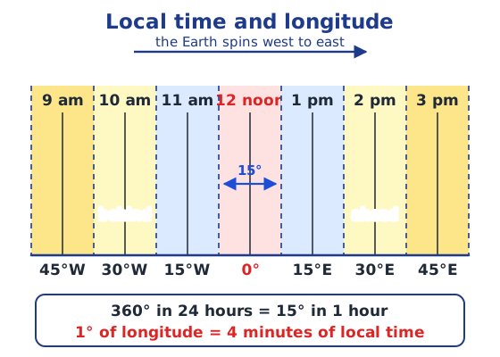
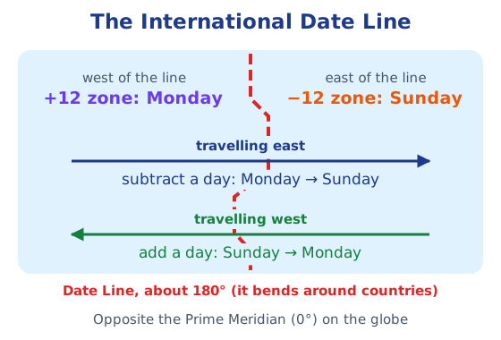
Many local times in one country would be confusing, so most countries follow one standard time. Indian Standard Time (IST) is 5 hours 30 minutes ahead of Greenwich Mean Time (GMT). Time zones roughly follow 15° bands but bend along borders; large countries have several, the USA six and Russia eleven. Opposite the Prime Meridian, at about 180°, runs the International Date Line: cross it eastward and you subtract a day, cross it westward and you add one. Read more in Indian Standard Time.
Answers to every question in the chapter are in the NCERT solutions for Chapter 1.
Key terms
| Term | Meaning |
|---|---|
| Map | A drawing of an area, small or large, as if you were looking at it from the top. |
| Atlas | A book or collection of maps. |
| Scale | How a distance on the map stands for a distance on the ground, for example 1 cm = 500 m. |
| Cardinal directions | The four main directions: north, east, south and west. Intermediate directions lie between them: NE, SE, SW and NW. |
| Symbols | Small signs that stand for features such as roads, railway lines, rivers, wells and buildings. In India the Survey of India fixes a standard set. |
| Globe | A sphere on which a map is drawn, such as a map of the Earth, the Moon or the stars. |
| Coordinates | Two values that fix a position, like ‘7th shop, 5th row’ or d4 on a chessboard. On the Earth they are latitude and longitude. |
| Equator | The imaginary circle halfway between the North and South Poles. It is latitude 0° and the longest parallel. |
| Latitude | The distance of a place north or south of the Equator, in degrees from 0° up to 90°N or 90°S. |
| Meridian of longitude | An imaginary half-circle running from the North Pole to the South Pole. |
| Prime Meridian | The 0° meridian through Greenwich in London, chosen in 1884 as the starting line for measuring longitude. |
| Longitude | The distance of a place east or west of the Prime Meridian, in degrees from 0° up to 180°E or 180°W. |
| Local time and standard time | Local time depends on a place's own longitude. Standard time is one time that a whole country follows, based on a meridian passing through it. |
| International Date Line | The line at about 180° longitude where the date changes by one day; it bends in places so that no country is split. |
Topics in this chapter
Practice
-
Which of these is NOT one of the three main components of a map?
Show answer
Answer: (d) Colour of the paper
-
On a map with the scale 1 cm = 10 m, a playground 40 m long is drawn as:
Show answer
Answer: (b) 4 cm
-
The latitude of the Equator is:
Show answer
Answer: (b) 0°
-
The Prime Meridian passes through:
Show answer
Answer: (c) Greenwich
-
Local time changes by one hour for every:
Show answer
Answer: (c) 15° of longitude
Questions students ask
What are the main topics of Class 6 SST Chapter 1?
Maps and their three components (distance or scale, direction and symbols), the globe, coordinates, latitudes and longitudes, the Prime Meridian and India's own madhya rekhā, local time, Indian Standard Time, time zones and the International Date Line.
Is Locating Places on the Earth in the new Exploring Society book?
Yes. Locating Places on the Earth is Chapter 1 of Exploring Society: India and Beyond, the Class 6 Social Science textbook used in the 2026-27 session. It opens the theme ‘India and the World: Land and the People’.
How many end-of-chapter questions does Chapter 1 have?
The “Questions, activities and projects” section has 8 questions, ending with a set of true-or-false statements and a crossword. Our NCERT solutions page answers them, along with the Big Questions and every Let's Explore box.
Stuck on a question?
Take a photo and Lagnever AI explains it step by step. Try it for 7 days for ₹2.
Get it on Google Play Open in browser
For parents: after the trial, the plan renews monthly by UPI or card autopay. You can cancel anytime in the app.