
NCERT Solutions Class 6 Social Science Chapter 3: Landforms and Life
Answers to the Big Questions, every Let’s Explore and Think About It box, the in-text questions and all 5 “Questions, activities and projects” in Chapter 3, Landforms and Life, of Exploring Society: India and Beyond (2026-27 session). The page numbers match the book. Activities about your own surroundings have sample answers; yours will differ. Short notes: Chapter 3 notes.
The Big Questions (page 41)
1. What are the major types of landforms and their significance to life and culture?
The three major landforms are mountains, plateaus and plains; deserts are another. They matter for life because they shape climate, water, soil and work: mountains store snow that feeds rivers, plateaus hold minerals, and plains have fertile soil for farming. They matter for culture too: mountains such as Kailash and Everest are worshipped, rivers and their confluences are sacred, poets like Kalidasa praised the Himalayas, Thar communities sing of the desert, and Tamil Sangam poetry built its five tinais on landscapes.
2. What are the challenges and opportunities of life on each landform?
| Landform | Opportunities | Challenges |
|---|---|---|
| Mountains | Pure air, scenery, tourism, pilgrimage, herding, forests, snow-fed rivers | Steep, rugged land; landslides, avalanches, cloudbursts, flash floods, cold, too many tourists |
| Plateaus | Minerals and mining, waterfalls, black soil on lava plateaus | Rocky, less fertile soil in many places |
| Plains | Fertile soil, farming, fishing, easy river travel, many towns | Crowding, pollution, falling groundwater, floods |
| Deserts | Unique plants, animals and cultures | Very little rain, heat or cold |
Let’s Explore: landscapes around us (page 42)
Around the school (sample): a school in a plains town sees flat land, fields, roads and a river or canal; within 50 km the land may stay flat, while a school near the Western Ghats or the Himalayas would soon reach hills. Groups usually find that the landscape changes faster in hilly areas than in plains.
A journey (sample): a train trip from Delhi to Shimla passes the flat, farmed plains of Haryana, then the foothills near Kalka, and then steep, forested mountain slopes with terraced fields and pine trees. A trip from Mumbai to Pune climbs from the coastal plain up the steep Western Ghats on to the Deccan Plateau.
Think About It: snow (page 43)
Snow is precipitation of water in a solid state. When the air high up is cold enough, water vapour in clouds freezes into tiny ice crystals that join into soft white flakes and fall as snow instead of rain. It falls in the Himalayan regions, such as Kashmir, Ladakh, Himachal Pradesh, Uttarakhand, Sikkim and Arunachal Pradesh, because they are high and cold. Hailstones are also frozen water, but they are hard balls of ice that can fall even in a warm-weather storm.
Kalidasa’s verses (page 46)
The ‘western to the eastern oceans’: the Arabian Sea in the west and the Bay of Bengal in the east. The poet imagines the Himalayas, the ‘Lord of mountains’, stretching right across the north of the subcontinent, from one sea to the other; on a map of India, they arc across the north from Jammu and Kashmir to Arunachal Pradesh.
Why is the Gangā mentioned? Several reasons: the Ganga is born in the Himalayas, from the snows of Gangotri; it is India’s most sacred river; its falling water fills the mountain air with cool spray; and it shows how the mountains give life to the plains below.
Let’s Explore: challenges of mountain life (pages 49–50)
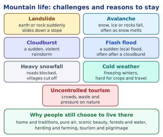
- Landslide: earth or rock suddenly slides down a slope, often after heavy rain or when slopes are cut for roads. It can bury homes and block roads for days.
- Flash flood: a sudden local flood, often after a cloudburst, that sweeps through narrow valleys with little warning, carrying away bridges, houses and fields.
- Uncontrolled tourism: too many visitors bring traffic jams, plastic waste, shortages of water and new buildings on fragile slopes, harming the environment that attracts them.
- Avalanche: a sudden fall of snow, ice or rocks, often when snow starts melting. It is dangerous for villages, roads and climbers.
- Heavy snowfall: roads and passes close, villages are cut off, and food, fuel and medicine are hard to bring in.
- Cloudburst: a sudden, violent rainstorm over a small area that dumps huge amounts of water in minutes, causing floods and landslides.
- Cold weather: long, freezing winters make farming possible only in a short season and make daily life, travel and keeping warm hard.
Why people still live there: the mountains are their home, with family, land, traditions and festivals; the air is pure and the scenery beautiful; forests, springs and rivers provide wood, water and food; herding, terrace farming, tourism and pilgrimages bring a living; and mountain communities have learnt over centuries how to live with these challenges.
Let’s Explore: landforms on the world map (page 53)
Using the colour code of the book’s map (Fig. 3.8):
| Mountain ranges | Plateaus | River plains |
|---|---|---|
| Rocky range, Alaska range, Andes range, Atlas range, Ural range, Himalaya range | Tibetan plateau, Mongolian plateau, East African plateau, Patagonian plateau | Mississippi plain, Amazon plain, Nile plain, Indus plain, Ganga and Brahmaputra plain, Yangtze plain |
Let’s Explore: the satellite view (page 54)
- The Ganga plain is the wide green expanse in the middle of the picture, the colour of its fields and crops.
- The white expanse at the top is the snow-covered Himalayas, with some clouds.
- The brown expanse at the bottom left is drier land with little green cover, towards the deserts and rocky uplands of the west.
Let’s Explore: rivers and tourist places (pages 55–56)
Sacred sources and confluences (examples): Gangotri (source of the Bhagirathi, the main stream of the Ganga) and Yamunotri (source of the Yamuna) in Uttarakhand; Devprayag, where the Bhagirathi and the Alaknanda meet to form the Ganga; Prayagraj, the confluence of the Ganga and the Yamuna; Amarkantak, source of the Narmada; Talakaveri, source of the Kaveri; and Trimbakeshwar, near the source of the Godavari. Choose the ones from your region.
Visiting a river (sample notes): economic activities such as fishing, boats carrying people or sand, washing clothes, irrigation pumps, and farms on the banks; cultural activities such as bathing on festival days, prayers and lamps at the ghats, immersion of idols, and fairs on the banks.
Tourist places and their landforms:
| Landform | Tourist places |
|---|---|
| Mountains and hills | Shimla, Manali, Darjeeling, Gangtok, Munnar, Ooty |
| Plateaus | Pachmarhi, Mahabaleshwar, Ranchi’s waterfalls, Cherrapunji |
| Plains | Agra, Varanasi, Delhi, Amritsar, Kolkata |
| Desert | Jaisalmer, Bikaner |
Questions, activities and projects (page 58)
1. Your town and its landform
Sample: Lucknow lies in the Ganga plain. Features from the chapter seen around it: flat land, fertile soil, fields of wheat and rice, a river (the Gomti), canals and tube wells for irrigation, and a large population. Someone in Shimla would describe mountains: steep slopes, terraces, pine and deodar forests, snow in winter and tourism.
2. The trip from Chhota Nagpur to Prayagraj and Almora
- Chhota Nagpur (plateau): raised, rolling land with a more or less flat top and steep edges, rocky soil, forests, mines of coal and iron, and waterfalls such as Hundru.
- Prayagraj (plain): flat, low, fertile land of the Ganga plain, with wide fields of wheat and rice, the Ganga and the Yamuna meeting at the Sangam, and many towns and villages.
- Almora (mountains): the Himalayan hills of Uttarakhand, with steep slopes, terraced fields, pine and deodar forests, winding roads and views of snow-capped peaks.
3. Pilgrimage spots and their landforms
| Landform | Pilgrimage spots |
|---|---|
| Mountains | Kedarnath, Badrinath, Amarnath, Vaishno Devi, Hemkund Sahib, Sabarimala |
| Plateau | Pandharpur and Shirdi on the Deccan Plateau, Amarkantak |
| Plains | Varanasi, Prayagraj, Bodh Gaya, Amritsar, Haridwar at the edge of the plain |
| Coasts | Puri, Rameswaram, Dwarka |
4. True or false
- The Himalayas are young mountains with rounded tops. False: they are young, with tall, sharp peaks; rounded tops belong to old mountains such as the Aravalli.
- Plateaus usually rise sharply at least on one side. True: some of their sides are often steep slopes.
- Mountains and hills belong to the same type of landform. True: both are highlands; hills are lower, with gentler slopes and rounded tops.
- Mountains, plateaus and rivers in India have the same types of flora and fauna. False: each environment has its own plants and animals, such as conifers and yaks in the mountains.
- Ganga is a tributary to the Yamuna. False: the Yamuna is a tributary of the Ganga.
- Deserts have unique flora and fauna. True.
- Melting snow feeds rivers. True.
- Sediments from rivers deposited in the plains make the land fertile. True.
- All deserts are hot. False: the Gobi is a cold desert, and some experts call Antarctica a desert.
5. Match the pairs
| Word | Pair |
|---|---|
| Mount Everest | climbing |
| rafting | river |
| camels | desert |
| plateau | roof of the world |
| Ganga plains | rice fields |
| waterway | Ganga |
| Mount Kilimanjaro | Africa |
| Yamuna | tributary |
For more practice, read mountains and life in the mountains, what is a plateau and what are plains.
Practice
-
Which is the highest mountain in south India?
Show answer
Answer: (b) Anamudi
-
Which falls drop 340 metres from the Cherrapunji Plateau?
Show answer
Answer: (c) Nohkalikai Falls
-
In the Sangam tinais, Neydal stands for:
Show answer
Answer: (b) coastal regions
-
Name two tributaries of the Ganga that rise in the Himalayas and one that rises in the Vindhya Range.
Show answer
Answer: The Yamuna and the Ghaghara rise in the Himalayas; the Son rises in the Vindhya Range.
-
What does ‘resilience’ mean?
Show answer
Answer: The capacity to meet challenges and difficulties, adapt to them or overcome them, as people have done by making every landform their home.
Stuck on a question?
Take a photo and Lagnever AI explains it step by step. Try it for 7 days for ₹2.
Get it on Google Play Open in browser
For parents: after the trial, the plan renews monthly by UPI or card autopay. You can cancel anytime in the app.