
Weather forecasts and warnings
Answer in short
A weather forecast predicts the weather hours, days or weeks ahead. Meteorologists collect readings from weather stations over long periods and study them scientifically. In India the India Meteorological Department issues colour-coded warnings, yellow to watch, orange to be prepared and red to take action, so that people and governments can prepare for heat waves, storms and floods.
Stuck on a question? Take a photo and Lagnever AI explains it step by step. Try it for 7 days for ₹2. Get it on Google Play
Reading Nature’s signs
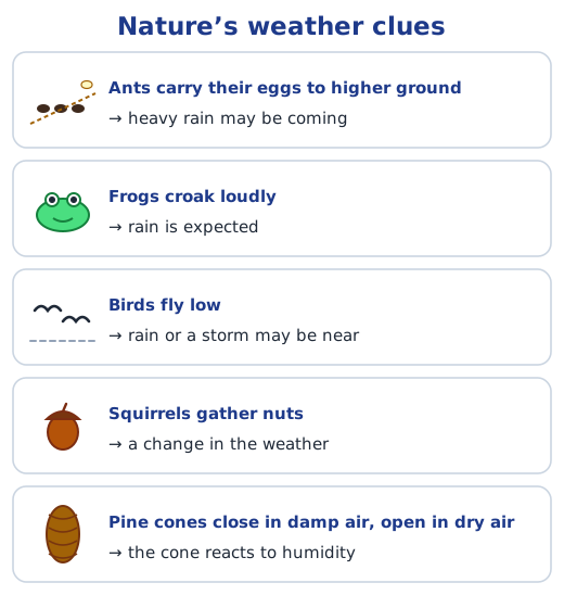
People forecast the weather long before there were instruments. Watching animals and plants gave them clues: ants shifting their eggs to higher ground before heavy rain, frogs croaking loudly when rain was near, birds flying low and squirrels gathering nuts. Pine cones shut tight when the air is damp, keeping their seeds safe, and open up when it is dry so the seeds can fall. This knowledge passed from one generation to the next, and in many parts of India people still use such signs, especially to guess when the monsoon will arrive. Ask the elders around you which signs they trust, and note any sayings about the weather in your language.
How forecasts are made
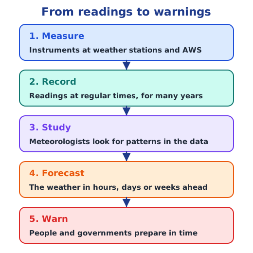
Meteorology, the careful scientific study of weather and how it develops, is the basis of forecasting. Meteorologists do not simply look at the sky and guess. Instruments at weather stations measure temperature, rainfall, pressure, wind and humidity; readings are taken at regular intervals and stored for many years; and scientists study these data to work out how the weather is likely to behave over the next few hours, days or even weeks. Automated Weather Stations now send many of these readings by themselves.
The India Meteorological Department
India’s national weather service, the India Meteorological Department (IMD), was set up in 1875. Its motto, adityat jayate vrishti, means “from the sun arises rain”. The line comes from the Manusmriti, which goes on to say that food comes from rain and living beings from food. The idea fits science: the sun’s heat evaporates water from seas, rivers and land, and that water vapour later falls as rain.
Colours and icons on a warning map
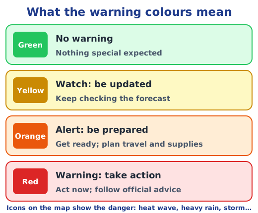
The IMD issues maps that colour each region by how serious the expected weather is, and add icons for the kind of danger: heat waves and cold waves, fog, hailstorms, dust storms, heavy snow, rain that is heavy, very heavy or extremely heavy, thunder and lightning, strong surface winds, hot and humid weather, and more.
The map of 19 May 2024
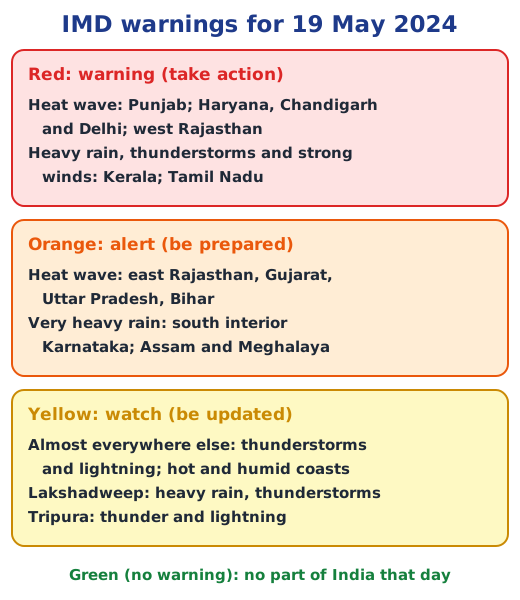
The chapter shows the IMD warning map for 19 May 2024. Two big events stand out. A heat wave gripped north-west and north India: Punjab, Haryana with Chandigarh and Delhi, and west Rajasthan were red, and east Rajasthan, Gujarat, Uttar Pradesh and Bihar were orange. In the south, Kerala and Tamil Nadu were red for heavy rain, thunderstorms and strong winds, while south interior Karnataka and Assam and Meghalaya were on alert for very heavy rain. Nearly everywhere else was yellow, mostly for thunderstorms and lightning, and the coasts of Konkan and Goa and Odisha were hot and humid. No region was green that day, so every part of India had some weather to watch.
Why predictions matter
Accurate forecasts give time to act. When a storm is expected at sea, fishermen are warned not to go out in their boats; when a cyclone approaches, a whole coastal area may be evacuated; and local governments can gather resources before a disaster. Farmers decide when to sow and harvest, pilots and sailors plan safe journeys, and families choose clothes and travel plans. Predictions matter even more now, as climate change makes droughts, floods and cyclones more frequent.
Why it matters
A forecast is only useful if you can read it. Learn what each element means in elements of weather and how it is measured in weather instruments. Worked answers to every textbook question, including the questions on the 19 May 2024 map, are in the NCERT solutions for Chapter 2; see all of the Chapter 2 notes.
Practice
-
What does red mean on an IMD warning map?
Show answer
Answer: (d) Warning: take action
-
Which Nature’s clue suggests that heavy rain is coming?
Show answer
Answer: (b) Ants moving their eggs to higher ground
-
Who studies weather data to make forecasts?
Show answer
Answer: (b) Meteorologists
-
How does a cyclone forecast help people on a coast?
Show answer
Answer: Fishermen are warned not to take their boats out, and the government can move people from the coast to safe shelters and get food, water and rescue teams ready before the storm arrives.
-
On the IMD map of 19 May 2024, which states faced the most severe heat wave?
Show answer
Answer: Punjab; Haryana, Chandigarh and Delhi; and west Rajasthan, which were coloured red (warning: take action) with heat-wave icons.
Questions students ask
How do meteorologists forecast the weather?
They measure temperature, rainfall, pressure, wind and humidity with instruments at weather stations, collect these readings for many years, and study them with scientific methods to see how the weather is likely to change over the next hours, days or weeks. Meteorology, the study of weather, is the basis of forecasting.
What do the colours on an IMD weather warning map mean?
Green means no warning; yellow means watch, so stay updated; orange means alert, so be prepared; and red means warning, so take action. Small icons show the kind of danger, such as a heat wave, heavy rain, thunder and lightning, strong winds or a dust storm.
What is the motto of the India Meteorological Department?
Adityat jayate vrishti, which means “from the sun arises rain”. It comes from the Manusmriti, where the full line says that rain comes from the sun, food from rain and living beings from food. The sun’s heat evaporates water, which later falls as rain.
Stuck on a question?
Take a photo and Lagnever AI explains it step by step. Try it for 7 days for ₹2.
Get it on Google Play Open in browser
For parents: after the trial, the plan renews monthly by UPI or card autopay. You can cancel anytime in the app.