
Class 8 Social Science Part 2 Chapter 1: World Geography: Some Glimpses Notes
This chapter in five lines
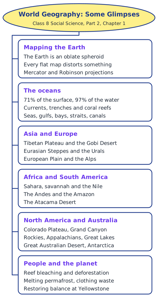
World Geography: Some Glimpses takes a quick tour of the Earth. It explains why every flat map distorts the round Earth, describes the oceans with their currents, trenches and coral reefs, and visits landforms on every continent, from the Tibetan Plateau and the Sahara to the Amazon and the Rocky Mountains. Along the way it shows how these features shape climate and life, and how human actions are harming them.
What is this chapter about?
In India the Earth has long been honoured as a mother, Bhudevi or Vasudha, and our lives depend on features far away: winds over the distant southern Indian Ocean help bring the monsoon to the Gangetic Plains. This chapter takes a quick tour of the planet. It asks three Big Questions: what makes each continent’s physical features special, why we should understand world geography, and how human actions cause environmental problems.
Mapping a round Earth
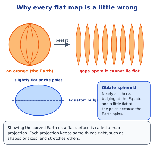
The Earth is an oblate spheroid, almost a ball but slightly flattened at the poles. Try to press the peel of an orange flat and it splits, and in the same way no flat map can show the Earth without distortion. Each map projection makes a different compromise. The Mercator projection keeps shapes and directions, so it suits navigation, but it swells lands near the poles until Greenland looks as large as Africa. The Robinson projection balances size and shape and looks more natural. For exact positions, professionals use latitude and longitude. Read mapping the Earth.
The blue planet
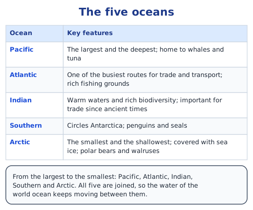
Oceans cover about 71% of the Earth’s surface and hold about 97% of its water. They are home to everything from plankton, which give us almost half our oxygen, to the blue whale, and they control climate by storing heat and adding moisture to the air. Currents move water like rivers in the sea: the warm Gulf Stream keeps the United Kingdom milder than other places at its latitude. The seafloor has mountains, plains and deep trenches; the Challenger Deep in the Mariana Trench is over 11,000 m deep. Coral reefs such as the Great Barrier Reef shelter a quarter of all ocean species. Smaller seas, gulfs, bays, straits and canals carry trade, and the Suez Canal, opened in 1869, is the shortest sea route from India to Europe. Read continents and oceans.
Asia and Europe
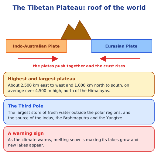
The tour starts near home. North of the Himalayas lies the Tibetan Plateau, the highest and largest plateau, pushed up by the same collision of tectonic plates that raised the Himalayas. Called the Third Pole, it stores more fresh water than anywhere outside the polar regions and feeds the Indus, Brahmaputra and Yangtze. To the north-east is the cold Gobi Desert, then the vast Eurasian Steppes, a grassland that locks carbon into the soil. The old Ural Mountains separate Europe from Asia. West of them spreads the fertile European Plain, and to its south the crescent of the Alps, which feeds the Rhine and the Danube.
Africa and the Americas
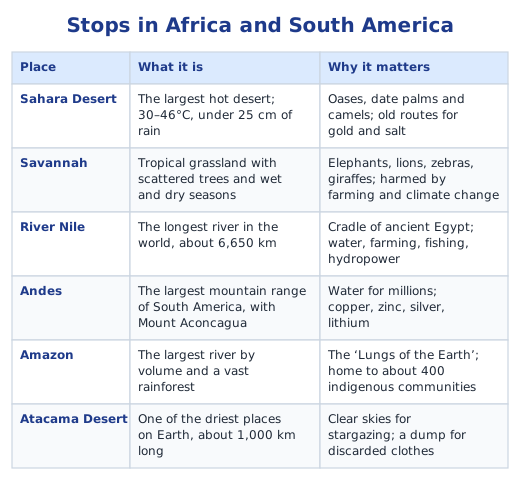
The Sahara is the largest hot desert, crossed for centuries by nomads and traders in gold and salt. South of it the savannah, a grassland with scattered trees, supports elephants, lions, zebras and giraffes, and the Nile, about 6,650 km long, gave rise to ancient Egypt. In South America the Andes feed the Amazon, the largest river by volume, whose rainforest is called the ‘Lungs of the Earth’, while the Atacama is one of the driest places on Earth. North America has the Colorado Plateau with the Grand Canyon, the Rocky Mountains with Yellowstone, the very old Appalachians and the five Great Lakes.
Australia and Antarctica
Much of Australia is dry land, the Great Australian Desert, which includes the Great Victoria Desert. Wallabies, bilbies, dingoes and wild camels live there, and the Spinifex people have lived in it for over 25,000 years. The largest desert of all is not hot: Antarctica, over 14 million km², over four times as big as India, is the coldest desert on Earth.
People and the planet
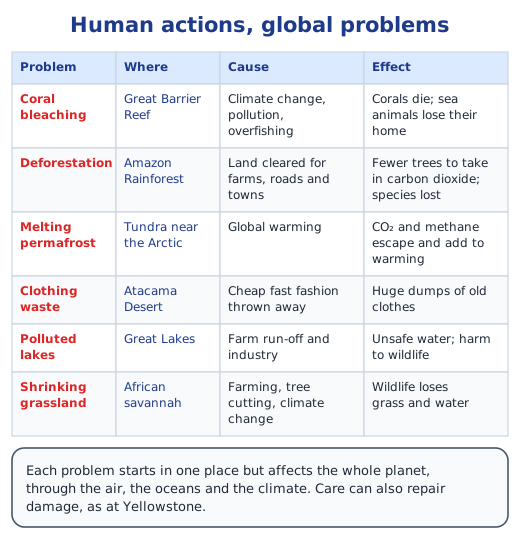
Everywhere on the tour, human actions leave marks. Changing ocean water bleaches corals, forests are cleared in the Amazon, melting permafrost releases greenhouse gases, and cheap clothes pile up in the Atacama. Care can also heal: wolves brought back to Yellowstone in 1995 restored the balance of its ecosystem. Read human actions and environmental issues.
Looking back and forward
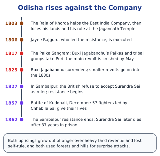
The chapter ends with a bridge to the next one, recalling two early revolts in Odisha. In the Paika Sangram of 1817, the Paikas, peasant soldiers who had lost their lands to high British revenue demands, rose with tribal groups under Buxi Jagabandhu and took Puri. In Sambalpur, Surendra Sai led resistance from 1827 to 1862.
Before we move on
The Earth’s mountains and plateaus, its plains, deserts and grasslands, and its rivers and oceans shape climate, wildlife, farming, settlement and trade. Human actions such as cutting forests, overusing resources and polluting upset this balance, so understanding world geography helps us use the planet wisely. Answers to every question are in the NCERT solutions for Part 2 Chapter 1.
Key terms
| Term | Meaning |
|---|---|
| Oblate spheroid | The Earth’s true shape: nearly a sphere, bulging a little at the Equator and slightly flattened at the poles because it spins. |
| Map projection | A way of showing the curved surface of the Earth on a flat map; every projection distorts shape, size, distance or direction. |
| Cartographer | A person who draws or makes maps. |
| Plankton | Tiny organisms floating in water; those with chlorophyll make food from sunlight and carbon dioxide and give off oxygen. |
| Ocean current | A steady flow of ocean water, like a river in the sea; warm currents move towards the poles and cold ones towards the Equator. |
| Trench | A very deep, V-shaped part of the seafloor; the Mariana Trench is the deepest. |
| Reef | A ridge at or near the surface of the sea, made of rock or built by tiny animals called corals. |
| Strait | A narrow channel of water joining two seas or oceans, such as the Strait of Malacca. |
| Tectonic plates | Huge pieces of the Earth’s crust whose movements build mountains and plateaus; the Himalayas rose where two of them collided. |
| Steppe | A large, flat, treeless grassland with hot summers, cold winters and moderate, often seasonal rain. |
| Water towers | A name for mountains, because their snow and glaciers melt slowly and feed rivers with fresh water. |
| Tundra and permafrost | A treeless, cold plain whose soil, called permafrost, stays frozen most of the time and holds greenhouse gases. |
| Savannah | A tropical grassland with scattered trees and a wet and a dry season, lying between rainforests and deserts. |
| Conservation hotspot | A region where people work to protect native plants and animals that are disappearing, usually because of human activity. |
Topics in this chapter
Practice
-
On a physical map, dark brown usually shows:
Show answer
Answer: (c) high mountains
-
Which projection makes Greenland look as big as Africa?
Show answer
Answer: (b) Mercator
-
About what share of the Earth’s surface do the oceans cover?
Show answer
Answer: (c) 71%
-
The mountain range that forms a natural boundary between Europe and Asia is the:
Show answer
Answer: (b) Urals
-
Which is the largest desert on Earth?
Show answer
Answer: (d) Antarctica
-
The Suez Canal joins the Red Sea to the:
Show answer
Answer: (b) Mediterranean Sea
Questions students ask
What are the main topics of Class 8 Social Science Part 2 Chapter 1?
Physical maps and why every map projection distorts the Earth; the oceans, their currents, trenches and coral reefs; seas, gulfs, bays, straits and canals; a tour of landforms on each continent, from the Tibetan Plateau and the Urals to the Sahara, the Andes, the Rockies and the Great Australian Desert; and how human actions cause environmental problems.
Is World Geography: Some Glimpses in the new NCERT Class 8 book?
Yes. It is Chapter 1 of Exploring Society: India and Beyond, the Class 8 Social Science textbook Part 2 (first edition June 2026). It is part of the book’s theme on India and the world, its land and its people. Part 2 numbers its chapters from 1 again, after the 7 chapters of Part 1.
What are the three Big Questions of this chapter?
They ask what makes the physical features of each continent special, why world geography is worth understanding, and how human actions lead to environmental problems. The chapter answers them through a tour of oceans and landforms, showing how each affects climate, wildlife and people.
Why is the Earth called the blue planet?
Because about 71% of its surface is covered by oceans, which hold about 97% of all its water. Seen from space the Earth looks mostly blue, which is why early astronauts gave it that name.
Stuck on a question?
Take a photo and Lagnever AI explains it step by step. Try it for 7 days for ₹2.
Get it on Google Play Open in browser
For parents: after the trial, the plan renews monthly by UPI or card autopay. You can cancel anytime in the app.