
NCERT Solutions Class 8 Social Science Part 2 Chapter 1: World Geography: Some Glimpses
Answers to every question in Part 2 Chapter 1, World Geography: Some Glimpses, of Exploring Society: India and Beyond Grade 8 (first edition, June 2026): each Let’s Explore and Think About It, the figure questions, and all eleven Questions and activities. Page numbers follow the chapter (pages 1–34). Short notes: Part 2 Chapter 1 notes.
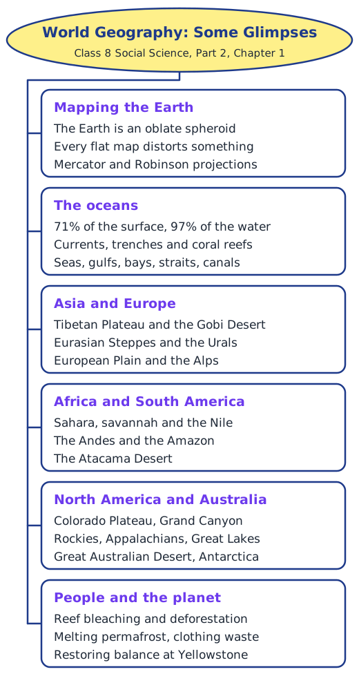
Let’s Explore and Think About It (pages 2–30)
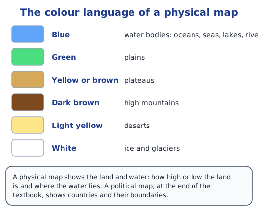
Page 2: what do the colours in Fig. 1.1 represent? Blue shows the oceans and seas; green shows forests and other plant cover on plains and lowlands; yellow and brown show deserts and dry or high land, such as the Sahara and Arabia; and white shows ice, snow and clouds, as over Antarctica. A physical map uses a similar colour code.
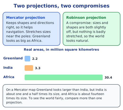
Page 3: Greenland and India in both maps. On the Mercator map Greenland looks bigger than India, but on the Robinson map it looks smaller. In reality India, about 3.3 million km², is larger than Greenland, about 2.2 million km²; the Mercator projection enlarges lands near the poles.
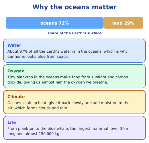
Page 4, Think About It: what if pollution harmed the plankton? The air would get almost half its oxygen supply cut off, so all breathing creatures would suffer. Plankton are also the first link of ocean food chains, so small fish, then larger fish, whales and seabirds would starve, and people who depend on fishing would lose food and jobs. More carbon dioxide would stay in the air, adding to global warming.
Page 11: physical features in Fig. 1.11. High mountain ranges such as the Himalayas and the Ural Mountains (dark brown); the Tibetan Plateau (brown); the Gobi Desert (light yellow); the grassland of the Eurasian Steppes and the forests of the Siberian Taiga; low plains (green); rivers and seas; the Pacific, Indian and Arctic Oceans (blue); and ice in the far north (white).
Page 12, Fig. 1.12: differences between 1987 and 2021. In the later picture the lakes on the plateau are larger and some new lakes have appeared, while there is less snow and ice. Melting snow, caused by climate change, is filling the lakes.
Page 15: the Himalayas and the four roles of mountains. Climate: they block icy winds from Central Asia and stop the monsoon winds, so the northern plains get heavy rain. Water towers: their snow and glaciers feed the Indus, Ganga and Brahmaputra all year. Biodiversity hotspot: their forests and meadows shelter snow leopards, red pandas, musk deer, rhododendrons and medicinal plants. Natural boundary: they separate India from Tibet and Central Asia, and Nepal and Bhutan lie within them.
Page 18: countries of the European Plain. From west to east: France, Belgium, the Netherlands, Germany, Denmark, Poland, Lithuania, Latvia, Estonia, Belarus, Ukraine and the European part of Russia.
Page 22: the course of the Nile. Its longer branch, the White Nile, rises in the lake region of East Africa around Lake Victoria (Tanzania and Uganda), and the Blue Nile rises in Ethiopia. The river flows north through Uganda, South Sudan, Sudan and Egypt into the Mediterranean Sea.
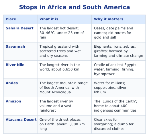
Page 24: why the Amazon is the ‘Lungs of the Earth’. It is the largest rainforest on Earth; its trees take in vast amounts of carbon dioxide and give out oxygen, and their moisture helps make rain, so the forest affects the whole planet’s air and climate.
Page 24: effects of deforestation and how to protect the Amazon. Short term: land for farms, cattle and roads, timber and jobs, but also smoke, lost habitats and indigenous communities pushed out. Long term: species lost for ever, less rain, eroded soil, more carbon dioxide and faster climate change. Protection: national parks and protected areas, land rights for the forest’s indigenous peoples, satellite checks on illegal logging, replanting, farming that does not need new clearings, and money from richer countries to help the region develop without cutting the forest.
Page 25: the Atacama’s clothing dumps. Fast fashion makes cheap clothes that are thrown away when trends change, and the waste ends up in places like the Atacama. We can buy fewer clothes, wear them longer, repair, swap and donate them, and companies can take back and recycle what they sell.
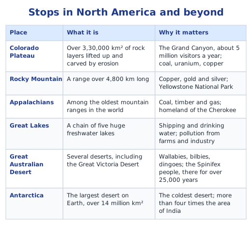
Page 29, Fig. 1.34: Australia’s landforms from the colours. Most of the centre and west is yellow or light brown, so much of Australia is desert or dry plateau, the Great Australian Desert. Green strips along the coasts, especially in the east and south-east, show plains, and brown along the east shows higher land. The Great Barrier Reef lies off the north-east coast.
Questions and activities (pages 31–32)
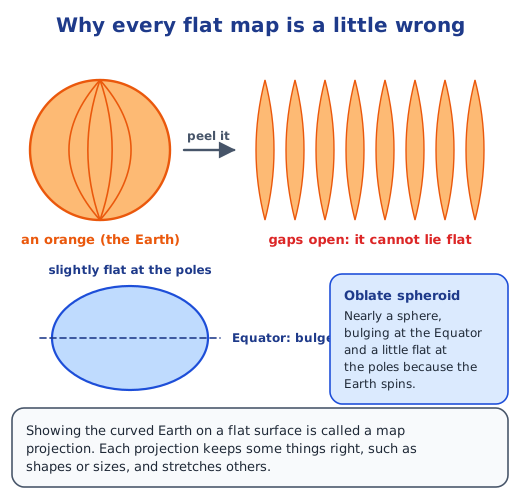
1. The Earth is an oblate spheroid, a curved surface. A curved surface cannot be laid flat without stretching, squeezing or tearing it, just as orange peel cannot be pressed flat. So every map projection gets something wrong: the Mercator keeps shapes but enlarges lands near the poles, while the Robinson balances size and shape but is not exact in either.
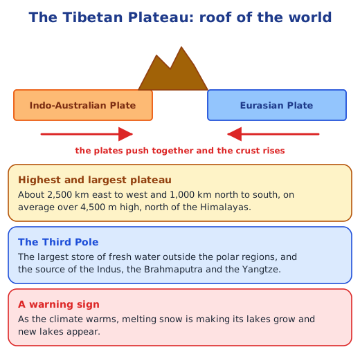
2. No plateau on Earth is higher or larger. It stretches some 2,500 km east–west and 1,000 km north–south, and its average height is more than 4,500 m. It was pushed up by the collision of the Indo-Australian and Eurasian plates, which also raised the Himalayas. Called the Third Pole, it holds the largest store of fresh water outside the polar regions, feeds the Indus, Brahmaputra and Yangtze, and influences the climate of Asia.
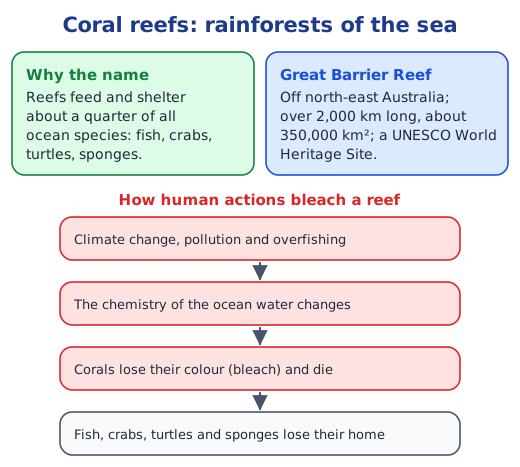
3. Like rainforests on land, coral reefs are among the most diverse ecosystems on Earth. They feed and shelter about one in four of all ocean species, from fish and crabs to turtles and sponges.
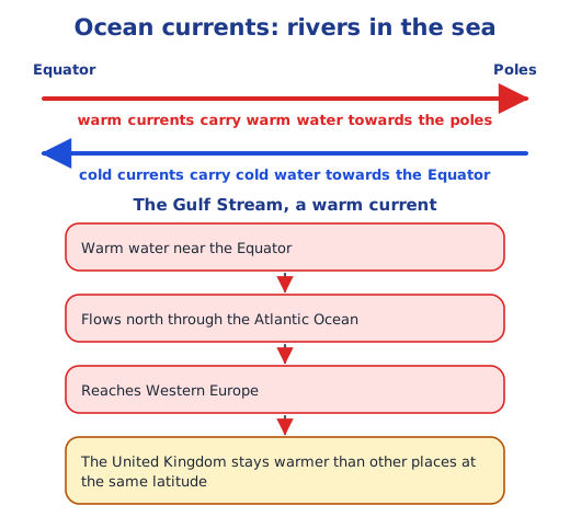
4. Oceans absorb heat from the sun and release it slowly, so coastal places stay milder; they add moisture to the air, which forms clouds and rain; and currents carry warm water towards the poles and cold water towards the Equator, as the Gulf Stream warms Western Europe.
5. Human activities. Above all, climate change is changing the chemistry of the ocean water, which bleaches and kills the corals; pollution and overfishing add to the damage.
6. The Amazon is the world’s largest rainforest. Through photosynthesis its trees take in huge amounts of carbon dioxide and release oxygen, much as lungs exchange gases, so it helps keep the air and climate of the whole Earth in balance.
7. The Sahara Desert: with temperatures of 30–46°C, sometimes over 50°C, and less than 25 cm of rain, few plants grow; cacti store water, date palms grow at oases, and the fennec fox loses heat through its large ears. People herd camels, goats and sheep as nomads, wear loose, covering clothes and some build homes underground to stay cool. Its effect is global: dust blown from the Sahara carries phosphorus that feeds the Amazon rainforest. The Tibetan Plateau: high and cold, it stores snow and ice that feed great rivers, so farms and cities far downstream depend on it; it also shapes Asia’s climate. As it warms, its lakes grow and new ones appear, a sign of climate change that affects water supplies across Asia.
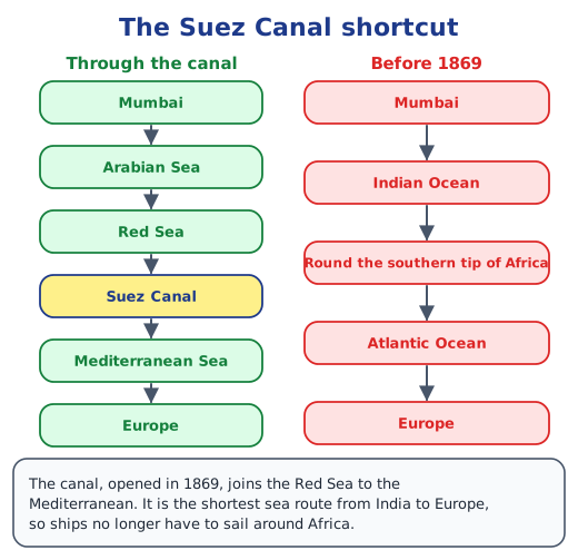
8. Indian Ocean: winds from the southern Indian Ocean help bring the monsoon to the Gangetic Plains, and its warm waters add moisture for rain. For thousands of years ships crossed it between India, Arabia, East Africa and Southeast Asia, through the Persian Gulf and the Bay of Bengal; today they reach Europe through the Red Sea and the Suez Canal. Pacific Ocean: the largest and deepest ocean stores enormous heat and moisture that shape weather all around it; changes in its temperature can even affect India’s monsoon. Ships across it link the ports of East Asia with the Americas, and the Strait of Malacca joins it to the Indian Ocean, one of the busiest shipping routes in the world.
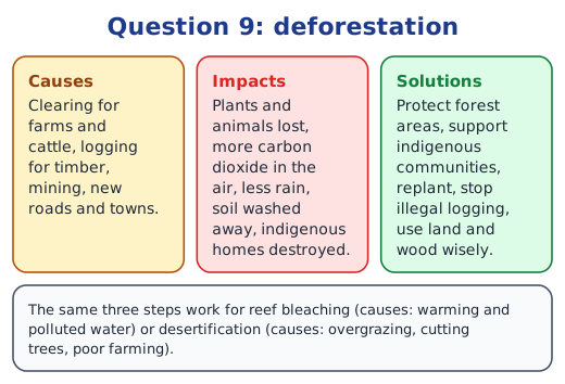
9. Deforestation, for example in the Amazon. Causes: clearing land for farms and cattle, logging, mining, roads and towns. Impacts: plants and animals lost, more carbon dioxide and faster climate change, less rain, soil erosion, and indigenous communities losing their homes. Solutions: protected areas, land rights for indigenous peoples, replanting, checks on illegal logging, and buying wood and food that do not cost forests. The same approach works for reef bleaching (caused by warming and polluted water) or desertification (caused by overgrazing, cutting trees and poor farming).
10. A sample answer: the Western Ghats. This long range of hills along India’s west coast is a biodiversity hotspot, full of plants and animals found nowhere else, and the source of rivers such as the Godavari, the Krishna and the Kaveri. It is threatened by mining, quarrying, deforestation, landslides and unplanned building. I would advise protecting its forests, controlling mining and construction on its slopes, involving local communities in caring for it, and allowing only eco-friendly tourism. (The Himalayas, the Sundarbans or the Thar Desert would also make good choices.)
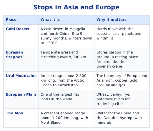
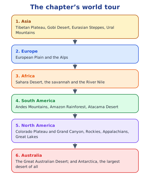
11. An activity; a sample pitch: Asia and Europe by road. Start in Delhi, cross the Himalayas onto the Tibetan Plateau, visit the cold Gobi Desert, stay in a yurt on the Eurasian Steppes, cross the Ural Mountains from Asia into Europe, drive across the European Plain through Moscow, Warsaw and Berlin, and end in the Alps. In one trip we would see a plateau, a desert, a grassland, mountains and a plain, all joined by land. Trace the route on a blank map, mark each stop, and present it with a poster, photos or a short role-play to win the group over.
Looking back and forward (pages 33–34)
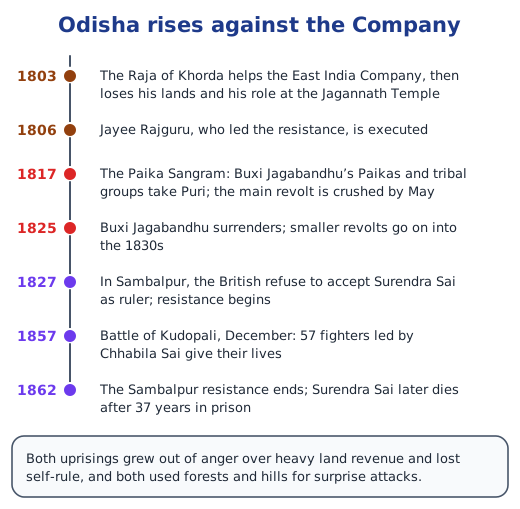
This bridge to the next chapter has no questions. It recalls the Paika Sangram (1817) in Khorda, Odisha, when the Paikas, peasant soldiers who had lost their lands to British tax demands, rose with tribal groups under Buxi Jagabandhu, and the Sambalpur Uprising (1827–1862) led by Surendra Sai.
Short notes and more practice are on the topic pages: continents and oceans, mapping the Earth and human actions and environmental issues.
Practice
-
Which colour shows plateaus on a physical map?
Show answer
Answer: (c) Yellow or brown
-
The Tibetan Plateau is called the ‘Third Pole’ because it:
Show answer
Answer: (b) holds the largest store of fresh water outside the polar regions
-
Which river is the largest in the world by volume?
Show answer
Answer: (b) Amazon
-
Why does every map projection have some distortion?
Show answer
Answer: The Earth’s surface is curved, and a curved surface cannot be spread flat without stretching or tearing, just like orange peel. So every flat map gets some shapes, sizes, distances or directions wrong.
-
Name two ways in which the oceans help regulate the Earth’s climate.
Show answer
Answer: They soak up heat and release it slowly, which keeps temperatures steady, and they add moisture to the air, which forms clouds and rain. Currents such as the warm Gulf Stream also carry heat from the Equator towards the poles.
Stuck on a question?
Take a photo and Lagnever AI explains it step by step. Try it for 7 days for ₹2.
Get it on Google Play Open in browser
For parents: after the trial, the plan renews monthly by UPI or card autopay. You can cancel anytime in the app.