
Mapping the Earth: why every map is a compromise
Answer in short
Mapping the Earth means showing its curved surface on flat paper, which always causes some distortion, just as orange peel cannot be pressed flat without tearing. Each map projection is a compromise: the Mercator keeps shapes and directions but enlarges lands near the poles, while the Robinson balances size and shape. Physical maps use colours to show landforms.
Stuck on a question? Take a photo and Lagnever AI explains it step by step. Try it for 7 days for ₹2. Get it on Google Play
The shape of the Earth
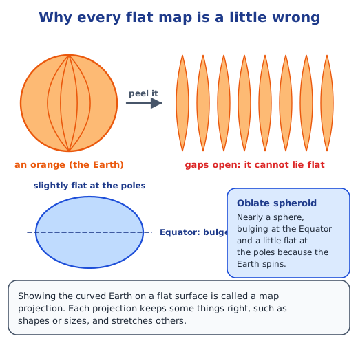
The Earth is not a perfect ball. Because it spins, it bulges a little around the Equator and is a bit flatter at the poles; this shape is called an oblate spheroid. Take an orange as a model of the Earth, peel it carefully and try to lay the peel flat. However you press it, it splits or wrinkles. A map has the same problem: it must show a curved surface on flat paper, so something always gets stretched or squeezed.
What is a map projection?
The way mapmakers transfer the curved Earth onto a flat sheet is known as a map projection. Mapmakers, called cartographers, have tried many projections over the centuries. Some keep the shapes of countries right but get their sizes wrong; others keep the sizes right but bend the shapes. No projection can keep everything correct at once, so every world map is a compromise. A map made for sailors, a map for comparing the areas of countries and a map for a school atlas may therefore all look slightly different, even though they show the same Earth.
Mercator and Robinson
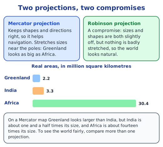
The Mercator projection keeps shapes and directions correct. A straight line on it is a steady compass bearing, which is why it has long helped sailors navigate. The price is size: lands look bigger and bigger towards the poles, so Greenland looks as big as Africa and larger than India, though India is in fact about one and a half times its area. The Robinson projection accepts small errors in both size and shape so that nothing is badly distorted, which gives a more realistic-looking map of the whole world. To understand the world fairly, it helps to look at more than one projection, not just one.
Reading a physical map
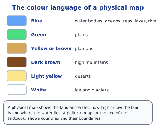
This chapter uses physical maps, which show the land and water rather than countries. They have their own colour language. Blue marks water bodies such as oceans, seas, lakes and rivers. Green shows plains, yellow or brown shows plateaus, and dark brown shows high mountains. Light yellow is used for deserts, and white for ice and glaciers. So a map of Australia that is mostly yellow tells you at once that much of the continent is dry, while a strip of green along a coast shows low plains.
Scales, legends and coordinates
Maps also carry tools for reading them. A scale shows what real distance a length on the map stands for, for example 0 to 1,000 km. A legend explains the symbols used, such as a line for a route or a dot for a city, and the directions, north, south, east and west, show which way is which. A world map gives a good picture of shapes, sizes, locations and distances, but for precise work professionals use latitude and longitude, the grid of coordinates met in Grade 6, which can fix any place exactly. The rest of the chapter is in the Chapter 1 notes, the oceans in continents and oceans, and every question in the NCERT solutions.
Practice
-
Which phrase describes the Earth’s shape correctly?
Show answer
Answer: (b) an oblate spheroid
-
The Mercator projection is especially useful for:
Show answer
Answer: (b) navigation
-
On a physical map, light yellow usually shows:
Show answer
Answer: (b) deserts
-
Why can no flat map show the Earth without distortion?
Show answer
Answer: The Earth is a curved, nearly round surface. Like orange peel, it cannot be spread flat without stretching or tearing somewhere, so every flat map changes some shapes, sizes, distances or directions.
-
Greenland looks as big as Africa on a Mercator map. Is it?
Show answer
Answer: No. Africa is about fourteen times larger. The Mercator projection stretches lands more and more as they get closer to the poles, and Greenland is far to the north.
Questions students ask
What is a map projection?
A map projection is a method of showing the curved surface of the Earth on a flat sheet. Cartographers, the people who make maps, have designed many projections; some keep the shapes of countries right but get their sizes wrong, while others keep sizes right but bend shapes.
What is the difference between the Mercator and Robinson projections?
The Mercator projection keeps shapes and directions correct, which is why sailors use it, but it hugely enlarges areas near the poles. The Robinson projection lets both size and shape be slightly wrong so that nothing is badly stretched, giving a more natural-looking world map.
Why is the Earth called an oblate spheroid?
Because it is not a perfect sphere. The Earth spins, so it bulges slightly at the Equator and is a little flattened at the poles. The difference is small, but it makes the Earth an oblate spheroid rather than a ball.
Stuck on a question?
Take a photo and Lagnever AI explains it step by step. Try it for 7 days for ₹2.
Get it on Google Play Open in browser
For parents: after the trial, the plan renews monthly by UPI or card autopay. You can cancel anytime in the app.