
Factors that shape climate
Answer in short
Five main factors shape a region’s climate. Latitude: places near the Equator get more direct sunlight and are warmer. Altitude: air cools as height rises. Nearness to the sea: the sea keeps temperatures mild. Winds bring heat, cold or moisture. Topography: mountains block winds and force them to rise. Together they make India’s climates diverse.
Stuck on a question? Take a photo and Lagnever AI explains it step by step. Try it for 7 days for ₹2. Get it on Google Play
Many factors, one climate
Why are hill stations pleasant in May, when the plains below bake, and why does Chennai stay warm even in January? Some of the factors that create a climate work on the scale of the whole planet, others on the scale of a region or even a single valley. The chapter looks at five of them.
Latitude
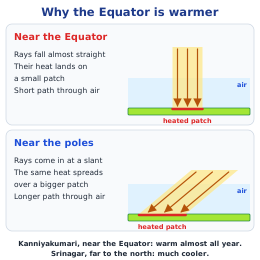
Latitude tells how far a place is from the Equator; it grows as one goes north or south. Near the Equator, at low latitudes, the Sun’s rays strike the ground almost at a right angle, so all their energy falls on a small area. Near the poles, at high latitudes, the rays come in at a slant: the same energy is spread over a larger area, and it also passes through more of the atmosphere, which weakens it further. So the polar regions get less heat than the equatorial zone, and climates change from hot to temperate to cold as latitude increases. In India, Kanniyakumari and the Nicobar Islands, near the Equator, stay warm or hot for nearly the whole year, while Srinagar in the north is much cooler.
Altitude
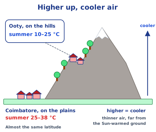
India’s hill stations, such as Shimla, Darjeeling, Nainital, Tawang, Shillong, Mount Abu, Mahabaleshwar, Madikeri, Munnar and Udhagamandalam (Ooty), are popular because they are cool. They are higher than the plains below, and temperature falls as altitude rises. One reason is that air pressure, and so the density of the air, decreases with height, and thinner air is cooler. Another is that the Sun heats the ground, which warms the air above it, so air far above the surface is less warm. Ooty and Coimbatore lie at almost the same latitude, yet Ooty’s summer temperatures range from about 10 to 25°C and Coimbatore’s from 25 to 38°C.
Nearness to the sea
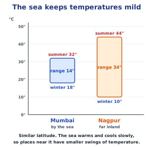
Land heats up and cools down quickly, while the sea does both slowly. So in summer the sea keeps coastal air cooler, and in winter it keeps it warmer: the sea acts as a moderator. Moving inland, temperatures become more extreme. Mumbai and Nagpur are at a similar latitude, but Mumbai, on the coast, has summers of around 32°C and winters of around 18°C, a range of about 14°C. Nagpur, far from the sea, reaches about 44°C in summer and falls to about 10°C in winter, a range of about 34°C.
Winds
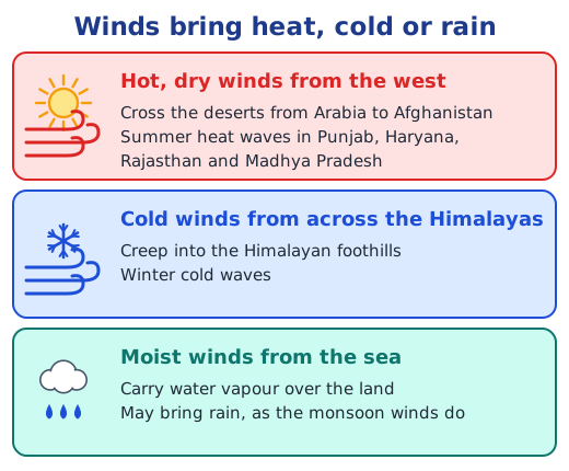
Winds move masses of warm or cool air. In summer, winds from the west that have crossed the deserts from Arabia to Afghanistan bring dry, hot air to Punjab, Haryana, Rajasthan and Madhya Pradesh and cause severe heat waves. During winter, icy winds from beyond the Himalayas slip into the foothills and bring cold waves. Winds also change humidity and rainfall: dry desert winds bring no rain, but winds from the sea carry moisture over the land and can bring rain, as the monsoon winds do.
Topography
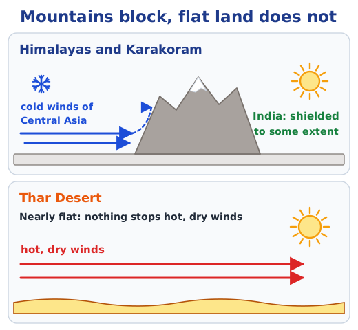
Topography is the shape of the land: its mountains, hills, valleys, slopes and coasts. The Himalayas and the Karakoram ranges protect the subcontinent, to some extent, from the cold winds of the Central Asian deserts. The Thar Desert, being nearly flat, has nothing to shield it from hot, dry winds. Mountains also force moist winds to rise and drop their rain, as the Western Ghats do in the monsoon.
Putting it together: climates and microclimates
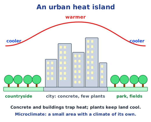
All these factors together decide a region’s climate, which is described by its usual temperature, precipitation (rain, snow, fog or mist) and winds over three decades or more. Within a region, a small area can have a microclimate of its own. Enclosed valleys and some forests have one, and so do urban heat islands: cities with many buildings and concrete and very few plants, which trap heat and are often much warmer than the land around them. Microclimates affect local plants, animals, crops and people’s health.
Why it matters
These factors explain why India has climates from alpine to tropical. Next, see how land, sea and wind work together in the monsoons, and how extreme weather turns into climate disasters. Answers to every question are in the NCERT solutions for Chapter 3; see all of the Chapter 3 notes.
Practice
-
Why are places near the Equator warmer?
Show answer
Answer: (b) The Sun’s rays fall on them more directly
-
Mumbai and Nagpur are at a similar latitude. Why is Mumbai’s range of temperature smaller?
Show answer
Answer: (b) It is near the sea
-
What is an urban heat island?
Show answer
Answer: (a) A city warmer than the land around it
-
Kanniyakumari is warm almost all year, but Srinagar is much cooler. Which factor mainly explains this?
Show answer
Answer: Latitude. Kanniyakumari is close to the Equator, where the Sun’s rays fall almost straight and heat a small area. Srinagar is much farther north, where the rays slant and spread their heat over a larger area after passing through more air.
-
How do the Himalayas affect India’s climate?
Show answer
Answer: With the Karakoram ranges, they act as a wall that shields the subcontinent, to some extent, from the cold winds of the Central Asian deserts. Their peaks are so high that many stay below freezing and remain covered in snow.
Questions students ask
What are the factors that determine climate?
The chapter names five. Latitude decides how directly the Sun’s rays fall; altitude makes higher places cooler; nearness to the sea moderates temperature; winds carry warm, cold, dry or moist air; and topography, the shape of the land, blocks or lifts winds. A region’s climate comes from all of them together, described through its temperature, precipitation and winds over three decades or more.
Why does temperature decrease with altitude?
For two simple reasons. Atmospheric pressure, and so the density of the air, falls as altitude rises, and thinner air is cooler. And the Sun heats the Earth’s surface, which then warms the air above it, so the farther the air is from the ground, the less warm it is. The highest Himalayan peaks stay below freezing.
What is a microclimate?
A climate localised in a small area that differs from the climate of the region around it, with its own pattern of temperature, humidity and precipitation. Enclosed valleys and some forests have microclimates, and so do urban heat islands, cities full of buildings and concrete with few plants, which trap heat and are often much warmer than their surroundings.
Stuck on a question?
Take a photo and Lagnever AI explains it step by step. Try it for 7 days for ₹2.
Get it on Google Play Open in browser
For parents: after the trial, the plan renews monthly by UPI or card autopay. You can cancel anytime in the app.