
NCERT Solutions Class 7 Social Science Chapter 3: Climates of India
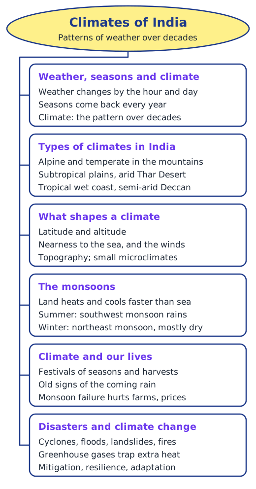
Answers to every question in Chapter 3, Climates of India, of Exploring Society: India and Beyond Grade 7 Part 1 (Reprint 2026-27): the Big Questions, every Let’s Explore and all seven questions and activities. Page numbers follow the book (pages 45–66). Answers that depend on where you live are given as samples to adapt. Short notes: Chapter 3 notes.
The Big Questions (page 45)
1. What makes India’s climate so diverse? India spans many latitudes, from near the Equator in the south to the cold north. Its land rises from sea-level coasts to the high Himalayas, it has a long coastline as well as places far inland, and its winds come from oceans, deserts and mountains. Its topography, with mountains, plateaus, plains and deserts, blocks or channels these winds. So it has alpine, temperate, subtropical, arid, tropical wet, semi-arid and tropical climates.
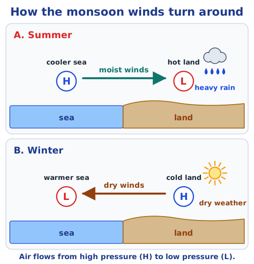
2. What are the monsoons? How are they formed? Monsoons are seasonal winds over the Indian Ocean and the lands around it, and the rains they bring. In summer the land heats up faster than the sea, so low pressure forms over it and moist winds blow in from the high-pressure sea and drop heavy rain. In winter the land cools faster and the winds reverse, blowing from land to sea.
3. What is the effect of climate on economy, culture and society? Farming, water supply, jobs, prices and even industry depend on the climate, above all on a good monsoon; a monsoon failure causes crop losses, water shortages, migration to cities and inflation. Festivals such as Baisakhi, Onam, Bihu and Pongal follow the seasons and harvests, and the rains have inspired ragas, songs and rituals.
4. How can understanding the climate help us to prepare for natural disasters? If we know which areas face cyclones, floods, landslides or forest fires, and in which season, we can heed warnings from the IMD, evacuate people in time, build safely, keep drains and waterways open, protect forests and slopes, and train rescue teams such as the NDRF. Knowing how climate change and disasters are linked also helps communities build resilience.
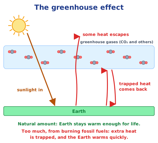
5. What is climate change? What are its consequences? Climate change is a significant, long-term change in temperature, rainfall and weather events. Today it is driven mainly by burning fossil fuels, which adds greenhouse gases that trap extra heat. Its consequences include rapid global warming, extremes of weather and temperature, shorter and milder winters, faster-melting glaciers, and harm to farming, industries, plants, animals and people.
Let’s Explore (page 47)
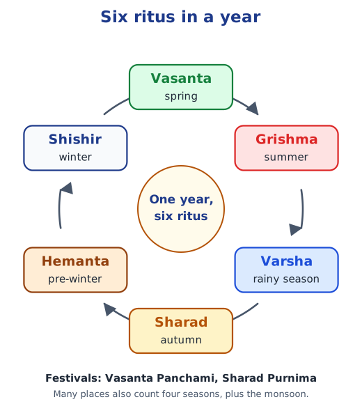
Your favourite seasons: a short essay. A sample: My favourite season is the monsoon. After weeks of heat, the first rain cools the air and the dry earth smells fresh. Fields turn green, frogs croak at night and we eat hot pakoras while the rain drums on the roof. I also like winter, when the sun feels gentle and the mornings are misty. Each season brings its own food, clothes and games. Write about your own favourites and why you like them.
Events connected to the seasons in your region. Samples to adapt: in Punjab, Lohri in mid-January marks the end of the cold with bonfires, songs and sweets of jaggery and sesame, and Baisakhi in April celebrates the wheat harvest with bhangra; in Assam, Bohag Bihu in April welcomes spring and the farming year with Bihu songs and dances; in Kerala, Onam celebrates the harvest with a grand feast, flower carpets and boat races. Collect the songs, foods and practices of your own region and share them with the class.
Trees that change colour or shed leaves before winter. Examples: the chinar of Kashmir turns red and golden in autumn, and trees such as teak and the silk cotton (semal) drop their leaves in the dry winter months. They do this to save water and energy: in the cold, dry season the roots take up little water while leaves keep losing it, so the tree sheds them and rests until spring. Note the local names of such trees around you.
Let’s Explore (page 51)
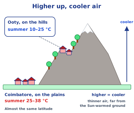
Why is Ooty (10–25°C in summer) so much cooler than Coimbatore (25–38°C) at almost the same latitude? Because of altitude. Ooty is a hill station high in the Nilgiri hills, while Coimbatore is on the plains below. Temperature falls as altitude rises: the air higher up is thinner, and it is farther from the ground that the Sun warms. (Extra: Ooty is about 1,800 m higher than Coimbatore.)
Let’s Explore (page 56)
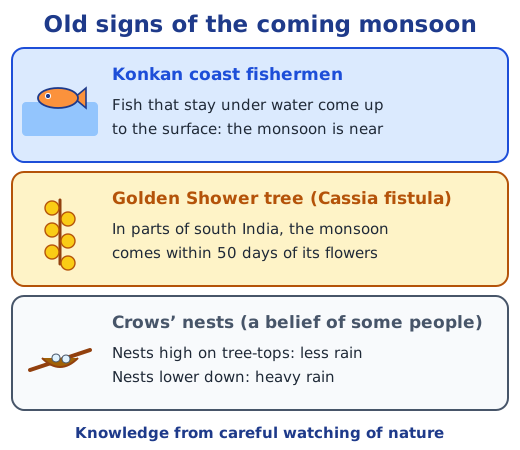
Local knowledge about rain, fog, snow or hail. A sample list of sayings heard in many places (they are beliefs to test by observation, not sure rules): ants carrying their eggs to higher ground means heavy rain is near; frogs croaking loudly means rain is coming; dragonflies flying low means rain within hours; a ring around the moon means rain in a day or two; dark, towering clouds on a hot, humid spring afternoon bring hail; and a clear, still, very cold night brings fog or frost the next morning. Add the beliefs of your own area.
Festivals and dances your elders remember. A sample plan: ask grandparents about festivals such as Teej, with swings and songs welcoming the rains, harvest festivals such as Baisakhi, Onam, Pongal or Bihu, and prayers or rituals held for rain when the monsoon was late. Note the songs, dances, foods and stories, then hold a class cultural fest where each group presents one tradition: a harvest dance, a rain song, or a short play about a prayer for rain.
Think About It (page 59)
What are clouds made of? Water: masses of tiny water droplets, ice crystals or a mix of both, floating in the atmosphere. They form when moist air rises and cools, and its water vapour condenses.
Let’s Explore (page 60)
Why do floods occur in Uttar Pradesh, Bihar, Kerala, Andhra Pradesh and Assam? Looking at the physical map:
- Uttar Pradesh and Bihar lie on the flat Ganga plains, crossed by large rivers from the Himalayas, such as the Ganga, Ghaghara, Gandak and Kosi, which swell with monsoon rain. Flat land drains slowly, so water spreads widely.
- Assam lies in the narrow Brahmaputra valley, ringed by hills that get very heavy rain; the Brahmaputra carries huge amounts of water and silt and overflows easily.
- Kerala gets very heavy southwest monsoon rain on the Western Ghats; its short, fast rivers rush down to a low, narrow coastal plain with backwaters.
- Andhra Pradesh has the low-lying deltas of the Godavari and Krishna, and cyclones from the Bay of Bengal often bring very heavy rain.
Let’s Explore (page 62)
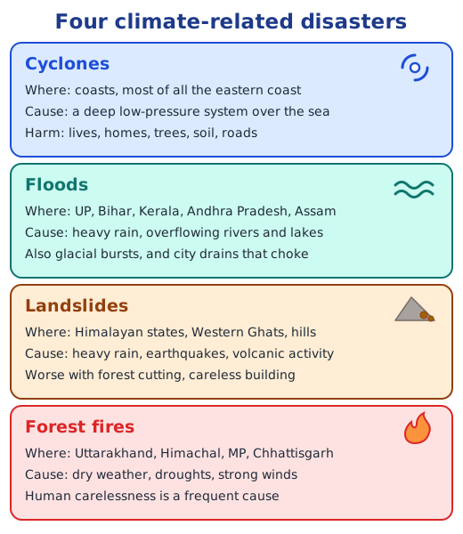
The effects of the disasters in Fig. 3.15.
- Landslide: people can be buried or cut off when roads and houses are destroyed; trees and soil are swept away; animals lose their habitat; trade and tourism stop until roads are cleared.
- Flood: people lose homes and belongings and may get water-borne diseases; crops are drowned and soil is washed away; livestock and wild animals drown or are stranded; farms, shops and transport stop.
- Cyclone: strong winds and storm surges kill people and damage homes; trees are uprooted; animals are killed; fishing, farming, power and communications are disrupted.
- Forest fire: smoke harms people’s health and homes near forests may burn; trees and plants are destroyed; wildlife dies or flees; timber, forest produce and tourism are lost.
Natural and human parts of each disaster.
- Cyclones: mostly natural (an intense low over a warm sea); human actions, such as cutting coastal mangroves and building too close to the shore, increase the damage.
- Floods: natural heavy rain, overflowing rivers and glacial bursts; human causes include building on waterways, blocked drains, concrete surfaces and fast-melting glaciers in a warming climate.
- Landslides: natural heavy rain and earthquakes on steep slopes; human causes include cutting forests, careless construction and blocking the natural flow of water.
- Forest fires: natural dry weather, droughts and strong winds; human carelessness, such as unattended fires and burning waste, is a frequent cause.
Preventive measures. Heed IMD warnings and evacuate early; build cyclone shelters and strong houses; plant and protect mangroves, forests and slope vegetation; keep drains and waterways open and stop building on them; follow approved building methods on hill slopes; watch forests in the dry season, clear fire lines and never leave fires burning; and train communities and rescue teams such as the NDRF.
Questions and activities (pages 65–66)
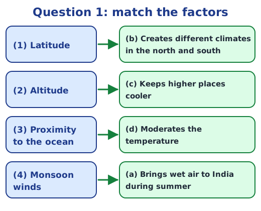
1. Match the climatic factors with their effects.
- (1) Latitude: (b) creates different climates in the north and south
- (2) Altitude: (c) keeps higher places cooler
- (3) Proximity to the ocean: (d) moderates the temperature
- (4) Monsoon winds: (a) bring wet air to India during summer
2. Answer the following questions.
(a) Weather and climate. Weather is what we experience from hour to hour or day to day, such as rain, sunshine, wind or heat, and it keeps changing. Climate is the pattern of weather that a region experiences over a long period, three decades or more. Weather can change overnight; climate stays stable for long periods.
(b) Why places near the ocean have milder temperatures. Water heats up and cools down much more slowly than land. In summer the sea stays cooler than the land and cools the coastal air; in winter it stays warmer and warms it. So the sea acts as a moderator. Mumbai, on the coast, swings only from about 18 to 32°C, while Nagpur, far inland at a similar latitude, swings from about 10 to 44°C.
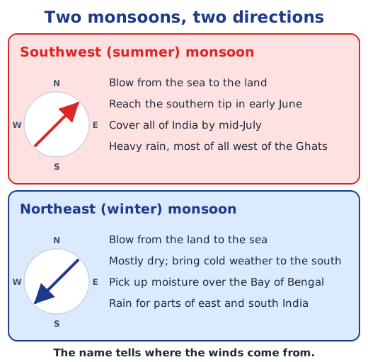
(c) The role of the monsoon winds. In summer they blow from the sea to the hot land and bring most of India’s rain, from early June in the south to the whole country by mid-July. This rain fills rivers and reservoirs, waters crops and decides the rhythm of farming. They make the western coast tropical wet and leave the Deccan semi-arid; in winter the reversed northeast monsoon is mostly dry but brings rain to parts of east and south India.
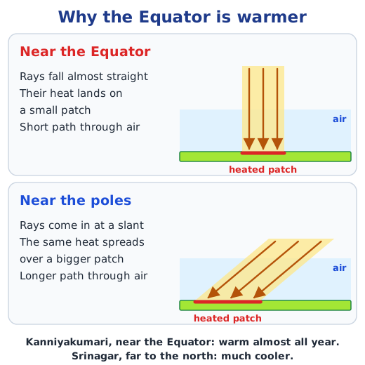
(d) Why Chennai is warm all year while Leh is cold. Chennai is at a low latitude, where the Sun’s rays fall almost straight all year; it is at sea level, and the sea next to it keeps its temperatures from falling much. Leh is much farther north, and above all it is very high in the mountains of Ladakh, where the air is thin and cold, and it is far from any sea.
3. The climate of five cities.
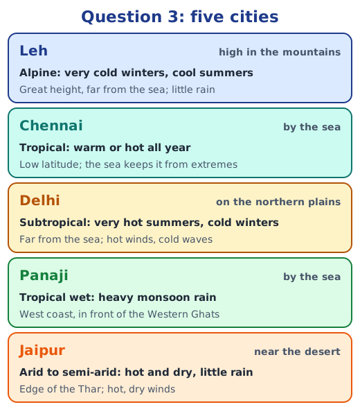
- Leh is in the mountains, at a great height in Ladakh. Its climate is alpine and very dry: very cold winters, cool summers and little rain, because of the altitude, the distance from the sea and the mountains that block moist winds.
- Chennai is near the sea, on the eastern coast at a low latitude. Its climate is tropical: warm or hot all year and humid, with the sea keeping the range small; it also gets rain from the winter (northeast) monsoon.
- Delhi is on the northern plains, far from the sea. Its climate is subtropical: very hot summers with dry winds from the west, cold winters with cold waves, and monsoon rain in summer.
- Panaji is near the sea, on the western coast, with the Western Ghats behind it. Its climate is tropical wet: heavy rain in the southwest monsoon and moderate temperatures all year.
- Jaipur is at the edge of the Thar Desert. Its climate is hot and dry, arid to semi-arid: very hot summers, cool nights, little rain and hot, dry winds; being inland, it has a large range of temperature.
4. The monsoon cycle on a map of India. On an outline map of India from your teacher or atlas:
- Summer: draw arrows from the Arabian Sea and the Bay of Bengal towards the land, pointing northeast, labelled southwest monsoon, moist winds from the sea. Mark the southern tip with early June and the north with by mid-July, and shade the western slopes of the Western Ghats as the area of heavy rain.
- Winter: draw arrows from the land towards the sea, pointing southwest, labelled northeast monsoon, dry winds from the land. Show one arrow crossing the Bay of Bengal and reaching the south-eastern coast, labelled rain for parts of east and south India.
- Add a key: H for high pressure and L for low pressure, over land and sea in each season.
5. A poster of festivals linked to farming and weather. Ideas for the poster, with a picture or drawing of each:
- Baisakhi (Punjab, April): the wheat harvest, celebrated with bhangra.
- Onam (Kerala, August–September): the harvest, with flower carpets, a grand feast and boat races.
- Pongal (Tamil Nadu, January): the harvest, with thanks to the Sun, rain and cattle.
- Bihu (Assam): Bohag Bihu in April welcomes the farming year, Magh Bihu in January marks the harvest.
- Lohri and Makar Sankranti (January): the end of the cold and the turn of the Sun northwards, with bonfires and kites.
- Chhath Puja (Bihar and nearby): prayers to the Sun at rivers and ponds.
6. A farmer’s diary before the rainy season. A sample:
Dear Diary, 25 May. The IMD says the monsoon will reach Kerala in early June, so we have about three weeks here. Today I repaired the bunds around my fields and cleared the channel so that water does not stand in the low corner. I mended the cowshed roof and stored dry fodder. Tomorrow I will buy paddy seed and prepare a small nursery, and get the plough ready. If the rains come late, I will sow a crop that needs less water. I pray for timely, steady rain.
7. An essay on a natural disaster: floods. Floods happen when water spills onto land that is normally dry. Causes: very heavy monsoon rain that the land cannot absorb, rivers and lakes overflowing their banks, glacial bursts in the Himalayas, and, in cities, choked drains, buildings on waterways and concrete that lets no water soak in. Impacts: people lose lives, homes and belongings, crops and soil are washed away, animals drown, diseases spread through dirty water, and roads, bridges, schools and businesses close, which hurts the economy for months. What we can do: individuals can keep drains clear of plastic and waste, keep an emergency kit and follow warnings; communities can plant trees on river banks, keep ponds and waterways open, and run flood drills; and the government can issue early warnings, build embankments and good drainage, stop construction on flood plains and waterways, and keep rescue teams such as the NDRF ready.
Short notes and more practice are on the topic pages: factors that shape climate, the monsoons and climate disasters and climate change.
Practice
-
Which climatic factor keeps higher places cooler?
Show answer
Answer: (b) Altitude
-
Which of these cities lies in the mountains?
Show answer
Answer: (c) Leh
-
Which festival celebrates the harvest in Kerala?
Show answer
Answer: (a) Onam
-
What is the difference between weather and climate?
Show answer
Answer: Weather is the state of the air from hour to hour or day to day and keeps changing. Climate is the usual pattern of weather in a region over a long time, three decades or more.
-
Why is Chennai warm all year while Leh is cold?
Show answer
Answer: Chennai is at a low latitude, close to sea level and beside the sea, so it gets strong sunshine and mild swings. Leh is much farther north and very high in the mountains, where the air is thin and cold.
Stuck on a question?
Take a photo and Lagnever AI explains it step by step. Try it for 7 days for ₹2.
Get it on Google Play Open in browser
For parents: after the trial, the plan renews monthly by UPI or card autopay. You can cancel anytime in the app.