
NCERT Solutions Class 7 Social Science Chapter 8: How the Land Becomes Sacred
Answers to every question in Chapter 8, How the Land Becomes Sacred, of Exploring Society: India and Beyond, the Class 7 Social Science textbook Part 1 (Reprint 2026-27): the Big Questions, all six Let’s Explore activities, the Think About It questions, the Kumbh Mela question, the sacred grove names and all eight Questions and activities. Page numbers follow the book (pages 167–184). Short notes: Chapter 8 notes.
The Big Questions (page 167)
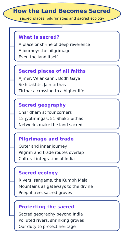
1. What is ‘sacredness’? In this chapter, something is sacred when it has deep religious or spiritual meaning and deserves respect and reverence. It can be a place or shrine, a special journey such as a pilgrimage and its route, or even the whole land that such journeys cover.
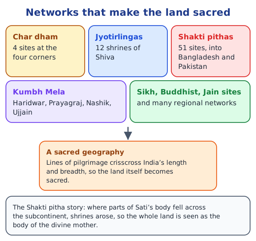
2. How does the land become sacred? Sacred sites are spread across India and joined into networks: the char dham at the four corners, the 12 jyotirlingas, the 51 Shakti pithas and many regional circuits. Pilgrims moving between them crisscross the country, so its whole geography comes to be seen as sacred. Many traditions also revere mountains, rivers, forests and the Earth herself, Bhudevi.
3. How do sacred sites and pilgrimage networks connect with people’s lives? They shape festivals, rituals and journeys, and give people a sense of belonging to a larger land. They support livelihoods, since pilgrims need food, lodging, transport, flowers and offerings, and pilgrimage routes overlapped with trade routes. Sacred rivers, groves and hills are also protected by the communities that revere them.
4. What role did sacred geography play in cultural integration? Pilgrims, traders, scholars and students travelling between sacred sites met many languages, customs and foods but also saw what they shared. Ideas, stories and goods moved along the same routes, so a common culture grew across the subcontinent, a feeling that Nehru described as ‘one country and one culture’.
Let’s Explore (page 168)
Familiar pictures and places nearby. The photographs show the kinds of places many of us know: a temple among trees, lamps floating on a river, a stupa, a temple tank, standing stones and a decorated sacred spot. Near most homes there is something similar: a temple or gurdwara, a mosque or church, a peepul or banyan tree with threads and offerings, a village pond, a shrine on a hill or a grove left untouched. Name the ones you know and say who visits them.
Let’s Explore (page 171)
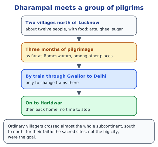
Dharampal’s pilgrims. Observations: ordinary villagers, women and men together, had travelled for three months across almost the whole country; they carried their own food; they used trains but kept a tight plan; and their goal was the sacred sites, not the big cities. Route: from Rameswaram they would have come north by rail through Tamil Nadu and central India, past Gwalior, to Delhi, and then on to Haridwar in Uttarakhand. Why go straight to Haridwar? Haridwar was a tirtha on their list, while Delhi was only a place to change trains; they had little time and needed to get home, so they went straight to their sacred goal.
From Madurai to Varanasi in ancient times. Travellers would hear Tamil, then other southern languages, then Marathi and many northern dialects. They could communicate through Sanskrit, the shared language of learning and ritual, through traders and local guides who knew several languages, and through gestures. They would stay at temples, monasteries and rest houses for pilgrims, or in villages along the way, and eat local food and temple offerings: rice dishes in the south, more wheat and millet in the north, along with food they carried.
Let’s Explore (page 173)
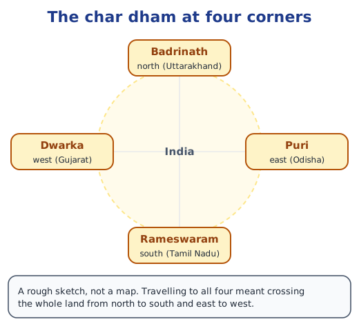
The char dham. Badrinath lies in the north, Rameswaram in the south, Puri in the east and Dwarka in the west. Travelling north to south and east to west to visit them meant crossing the whole country, meeting its many languages, foods and customs, and coming to feel that this vast, varied land was one sacred whole.
Let’s Explore (page 174)
Tirthas on the map (Fig. 8.6). The map shows networks without labels; using a political map, we can identify the char dham (Badrinath, Dwarka, Puri, Rameswaram), the Kumbh Mela sites (Haridwar, Prayagraj, Nashik, Ujjain), jyotirlingas such as Kedarnath, Somnath, Kashi Vishwanath (Varanasi) and Mahakaleshwar (Ujjain), Sikh sites such as Amritsar, Anandpur Sahib, Patna Sahib and Nanded, Buddhist sites such as Bodh Gaya and Sarnath, and Jain sites such as Girnar and Mount Abu.
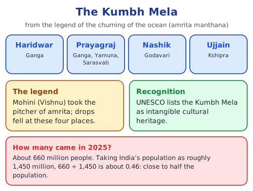
Don’t Miss Out (page 176): the Kumbh Mela of 2025
The book does not give India’s population; taking it as about 1,450 million in 2025, 660 ÷ 1,450 ≈ 0.46. So the number of participants equals about 46 per cent, nearly half of India’s population (some people may have been counted on more than one visit).
Think About It (page 177)
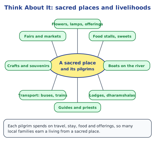
Sacred places and economic life. A mind map with the sacred place at the centre would branch out to: flowers, lamps and offerings; food stalls and sweets; boats on the river; lodges and dharamshalas; guides and priests; transport such as buses, taxis and trains; crafts and souvenirs; and fairs and markets. The photograph of a busy riverside town with ghats and boats gives these clues.
Think About It (page 179)
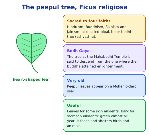
The useful peepul. Its leaves help with some skin ailments and its bark with stomach ailments, and because it stays green almost all year it feeds and shelters many birds and animals. Treating it as sacred has therefore also protected a tree of real value to people and wildlife.
Sacred grove names (page 180)
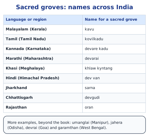
The table lists kavu, kovilkadu, devare kadu, devarai, khlaw kyntang, dev van, sarna, devgudi and oran. More names: umanglai in Manipur, jahera in Odisha, devrai in Goa and garamthan in West Bengal.
Let’s Explore (page 181)
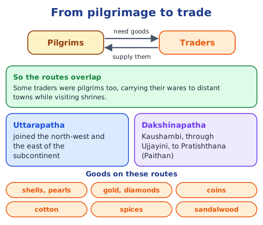
Trade routes over the tirtha map. Laying the trade routes of ‘The Rise of Empires’ over the map of tirthas shows that many sacred places sit on or near the trade routes: Prayag and Varanasi near the Uttarapatha, Ujjain on the Dakshinapatha, and ports and river towns on both. Pilgrimage routes and trade routes largely overlapped.
Think About It (page 182)
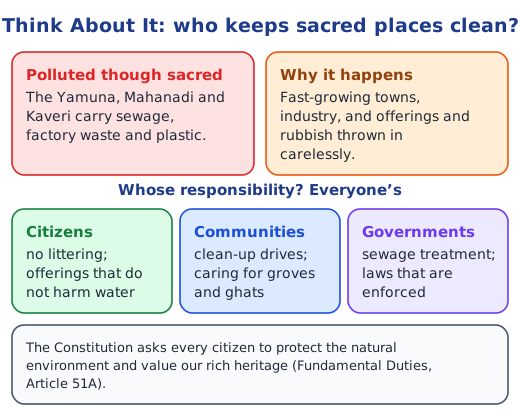
Why are sacred rivers polluted? Cities and industries along the Yamuna, Mahanadi and Kaveri pour sewage and factory waste into them; plastic, garbage and some offerings are thrown in; and too much water is drawn off, so the rivers cannot clean themselves. Many towns have similar problems with temple tanks, ponds and groves. Whose responsibility? Everyone’s: citizens should not litter and should choose offerings that do not harm water; communities can organise clean-ups and care for ghats and groves; and governments must treat sewage and enforce laws. The Constitution’s Fundamental Duties ask every citizen to protect the environment and value our heritage.
Questions and activities (pages 183–184)
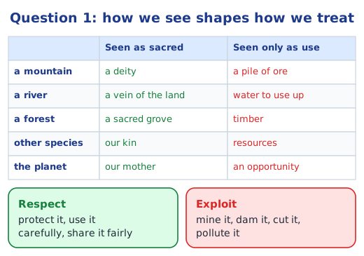
1. David Suzuki’s statement. It means that the way we look at nature decides how we behave towards it. If we see a mountain as a deity, a river as part of the land’s body, a forest as sacred, other species as relatives and the Earth as our mother, we will treat them, and one another, with respect; if we see them only as ore, water, timber and resources, we will exploit them. For our actions, it means using air, water, land and trees carefully, not polluting rivers or cutting trees needlessly, protecting hills and forests from reckless mining, and sharing nature’s gifts fairly.
2. Sacred sites in your region (sample, about 150 words). Haridwar, for a student from Uttarakhand. Haridwar is where the Ganga leaves the Himalayas and enters the plains, and for centuries pilgrims have come here to bathe at Har ki Pauri. In the legend of the churning of the ocean, a drop of amrita fell here, so Haridwar is one of the four places where the Kumbh Mela is held. Every evening, crowds gather on the ghats for the Ganga aarti, when lamps float down the river. On the hills nearby stand temples of Chandi Devi and Mansa Devi, reached by long stairways or ropeways. My grandparents say that families once walked here for weeks. The town lives from its pilgrims: priests, boatmen, flower sellers and lodge owners all depend on them. Keeping the river clean is now the town’s biggest challenge. Write yours after talking to elders and your teacher.
3. Why are rivers, mountains and forests sacred, and how do they help us? Many Indian traditions see the divine in all of nature, and rivers, mountains and forests are the most powerful parts of the landscape. Rivers give water for drinking, farming and transport and have been lifelines of civilisation; mountains feed rivers, shape the climate and feel like gateways to heaven; forests give food, fuel, medicine and shelter to wildlife, and keep soil and water in place. Revering them has helped people protect them.
4. Why do people visit a tirtha? To worship and seek blessings; to fulfil a vow or mark an important event; for an inner journey of discipline and spiritual growth; and to see the land, meet other people and share in festivals such as the Kumbh Mela. In the past, many also travelled to learn, to debate or to trade along the way.
5. Pilgrimage routes and trade. Pilgrims needed food, supplies and services, which traders along the way provided, so pilgrimage and trade routes overlapped, as on the Uttarapatha and Dakshinapatha, and some traders were pilgrims too. Do sacred sites develop the local economy? Yes: they create work in transport, lodging, food, offerings, crafts and guiding, and fairs bring trade. But big crowds can also strain water, waste systems and the environment, so growth needs care.
6. How sacred places shape the culture of people living near them. Local festivals, fairs and processions grow around them; special foods and prasad, music, dance and crafts develop; many families earn their living from pilgrims; stories and legends attach to the hills, trees and rivers nearby; and, as with sacred groves, rules grow up that protect the local environment.
7. A project on two sacred sites (example). Bodh Gaya (Bihar): where, in Buddhist tradition, the Buddha attained enlightenment under the bodhi tree; the Mahabodhi Temple; more than four million visitors a year from many countries. Prayagraj (Uttar Pradesh): the sangam of the Ganga, Yamuna and unseen Sarasvati; a Kumbh Mela site, the festival UNESCO lists as intangible heritage. For each, describe the location, the story, the faith or community linked with it, the festivals and visitors, its effect on the local economy and environment, and how it can be protected; add a map, pictures and a timeline.
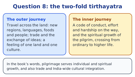
8. The two-fold significance of a tirthayatra. It is an outer journey and an inner one. Outwardly, it takes the pilgrim across the land, meeting new regions, languages and foods, and it supports trade and India-wide cultural integration. Inwardly, it is a spiritual journey with a code of conduct, where effort and hardship on the way stand for crossing from ordinary life to a higher one.
Short notes and more practice are on the topic pages: sacred geography of India, sacred groves and sacred ecology and pilgrimage and trade.
Practice
-
Which places make up the char dham?
Show answer
Answer: (a) Badrinath, Rameswaram, Puri, Dwarka
-
What is the Kumbh Mela listed as by UNESCO?
Show answer
Answer: (b) Intangible cultural heritage
-
Which community regards the Niyam Dongar hill as sacred?
Show answer
Answer: (b) The Dongria Khond
-
Name two benefits of sacred groves.
Show answer
Answer: They shelter great biodiversity of plants and animals, and they hold small water bodies that help conserve water; some also protect animals like fruit bats that pollinate flowers and spread seeds.
-
What did the new law in New Zealand give Mount Taranaki?
Show answer
Answer: The legal rights and duties of a person, recognising the Maori view of the mountain as an ancestor; community elders speak for it.
Stuck on a question?
Take a photo and Lagnever AI explains it step by step. Try it for 7 days for ₹2.
Get it on Google Play Open in browser
For parents: after the trial, the plan renews monthly by UPI or card autopay. You can cancel anytime in the app.