
Transport infrastructure in India
Answer in short
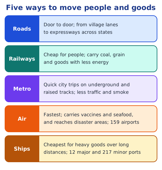
India’s transport infrastructure moves people and goods by road, rail, metro, air and sea. It has the world’s second-largest road network, with national highways of about 150,000 km, and the fourth-largest railway system, now almost fully electric. Metro trains run in 23 cities, 159 airports offer the fastest travel, and 12 major and 217 minor ports carry heavy goods.
Stuck on a question? Take a photo and Lagnever AI explains it step by step. Try it for 7 days for ₹2. Get it on Google Play
Roads and highways
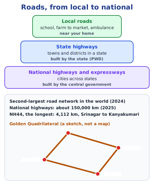
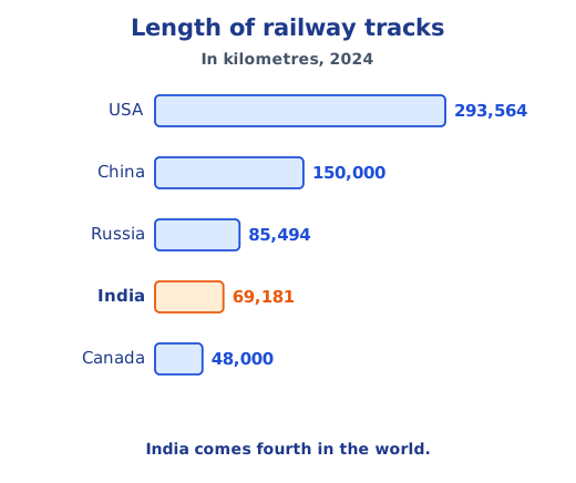
India’s road network is the second largest in the world, after that of the USA (2024). Local roads near our homes take children to school, farmers’ crops to market and ambulances to hospitals. State highways link towns and districts within a state and are built and kept up by the state’s public works department. National highways and expressways join cities across states, are built by the central government and connect with railway stations, airports and ports. National highways add up to about 150,000 km (2025); the longest, NH44, runs 4,112 km from Srinagar to Kanyakumari, and the Golden Quadrilateral links Delhi, Mumbai, Chennai and Kolkata.
Bridges across rivers and forests
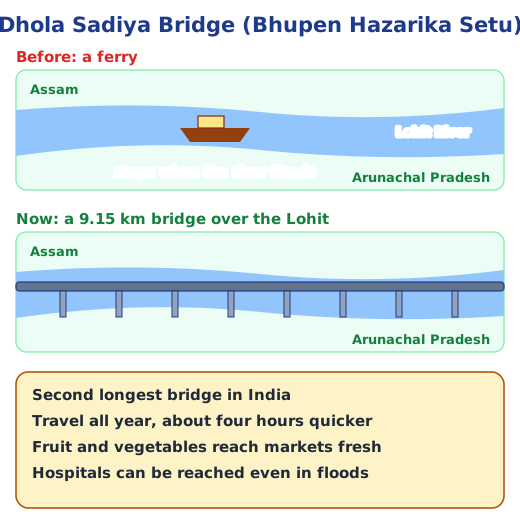
Highways cannot run straight through dense forests, wide riverbeds or steep mountains, so bridges and tunnels carry them across. The Dhola Sadiya Bridge, or Bhupen Hazarika Setu, spans the Lohit, a river that feeds the Brahmaputra, between Assam and Arunachal Pradesh. At 9.15 km it is India’s second longest bridge. Ferries used to stop in floods; now people travel all year, four hours faster.
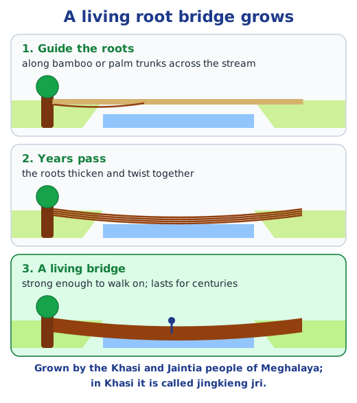
In Meghalaya, the Khasi and Jaintia people grow living root bridges, called jingkieng jri in Khasi. They guide the roots of the Indian rubber tree across a stream along bamboo or palm trunks, and over decades the roots twist into a strong bridge that can last for hundreds of years, linking one generation to the next.
Railways
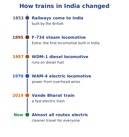
The British introduced railways in 1853 to move raw materials such as cotton and tea to ports for export, to sell British goods across India, to exploit resources and to move troops quickly. As the network grew, trade grew, markets developed and towns grew around stations.
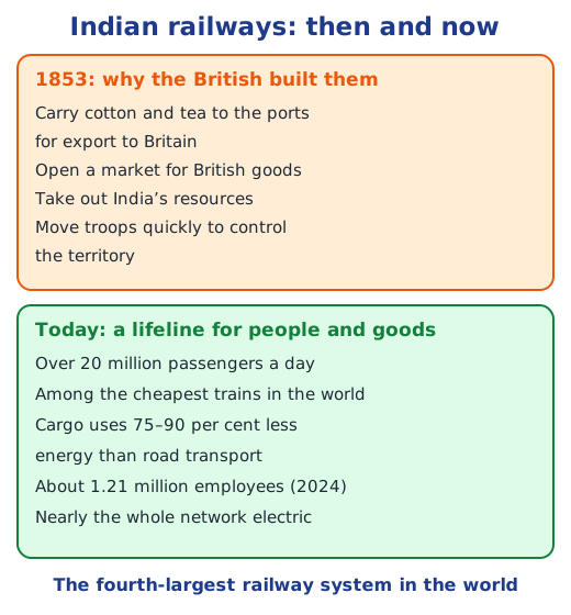
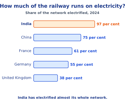
Today Indian Railways carries more than 20 million people every day, at fares among the lowest in the world. Goods trains move coal, grain, textiles and electronics on 75–90 per cent less energy than trucks would need. About 1.21 million people worked for the railways in 2024, and many more earn from catering, vending and taxis around stations. India’s network is the fourth-largest in the world and, at about 97 per cent, the most electrified of the five countries the book compares.
Metro trains
Metro trains run in 23 Indian cities over more than 1,000 km, and the network will soon rank third in the world, behind only China and the USA. Running on underground and raised tracks, they cut travel time and road traffic, and they use electricity; the Delhi Metro even uses some solar power.
Air transport
Flying is the fastest way to connect places. Passenger flights carry people, and cargo flights carry valuable or perishable goods such as vaccines, chemicals and seafood. Planes can reach mountains, deserts, forests and islands, so they bring aid quickly after floods or earthquakes. India has 159 airports (2025), and only the USA and China fly more passengers within their own borders: India carried about 376 million in 2024–25. Bengaluru’s Kempegowda airport is designed around the idea of a garden city.
Shipping and ports
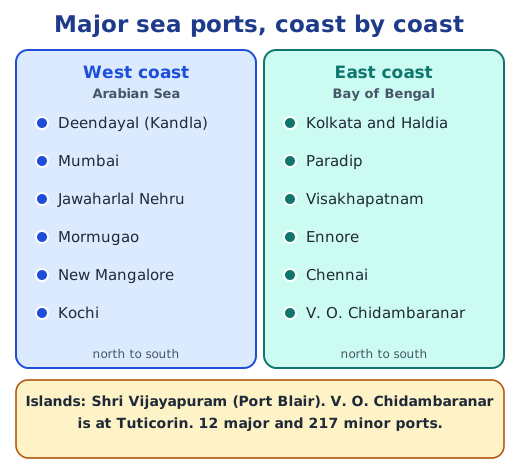
India’s coastline of about 11,100 km links it by sea with West Asia, Africa and Europe. Ships are the cheaper way to carry heavy goods such as coal, cars and cement over long distances. India has 12 major and 217 minor ports, and the cargo they handle has grown by half in the past decade. Container traffic is measured in TEU, twenty-foot equivalent units.
Why it matters
Each kind of transport fits a different need, and together they move people and goods across India. Read how all of it began in what is infrastructure, and how messages travel in communication infrastructure. Answers to the textbook questions are in the NCERT solutions for Part 2 Chapter 7; see all of Part 2 Chapter 7 notes.
Practice
-
Which is the longest national highway in India?
Show answer
Answer: (b) NH44
-
The Golden Quadrilateral connects Delhi, Mumbai, Chennai and:
Show answer
Answer: (c) Kolkata
-
A living root bridge is grown from the roots of which tree?
Show answer
Answer: (b) Indian rubber tree (Ficus elastica)
-
Why are ships used for goods such as coal, cars and cement?
Show answer
Answer: Ships are the cheaper way to move heavy goods over long distances. India’s coastline of about 11,100 km links it by sea with West Asia, Africa and Europe, and goods are loaded and unloaded at its ports.
-
How did the Dhola Sadiya Bridge change life in Assam and Arunachal Pradesh?
Show answer
Answer: Before it, people relied on ferries that stopped during floods. The 9.15 km bridge allows travel all year and saves about four hours, so farmers sell fruit and vegetables before they spoil and people reach hospitals even in floods.
Questions students ask
What kinds of roads are there in India?
Local roads near our homes take children to school, crops to markets and ambulances to hospitals. State highways link towns and districts within a state and are built by the state public works departments. National highways and expressways join cities across states and are built by the central government.
Why did the British build railways in India?
From 1853 the British used railways to carry raw materials such as cotton and tea to ports for export to Britain, to spread British goods across India, to exploit India’s resources and to move troops quickly, which tightened their control. Later, trade grew and new towns came up near stations.
Why is air transport useful in disasters?
Planes are the fastest way to travel, and they can reach high mountains, deserts, dense forests and far islands easily. So aircraft can carry relief, medicines and rescue teams quickly to people cut off by floods or earthquakes.
Stuck on a question?
Take a photo and Lagnever AI explains it step by step. Try it for 7 days for ₹2.
Get it on Google Play Open in browser
For parents: after the trial, the plan renews monthly by UPI or card autopay. You can cancel anytime in the app.